Near Rosh Pina - Metulla Road just east of Northern District Route 90, on the left when traveling east.
English Text:
Dated to the 10th century BCE, this gate has six chambers and two towers. Similar gates have been uncovered at Megiddo and Gezer. A summary of King Solomon's activities indeed indicates that the king built Hazor, Megiddo . . . — — Map (db m141365) HM
Near Rosh Pina - Metulla Road just east of Northern District Route 90, on the left when traveling east.
English Text:
The southern temple was in use from the Middle Bronze Age until the Late Bronze Age (17th-14th centuries BCE). The temple was originally a prominent structure, with wide, well-constructed walls, and its three strata of . . . — — Map (db m141372) HM
Near Rosh Pina - Metulla Road just east of Northern District Route 90, on the left when traveling east.
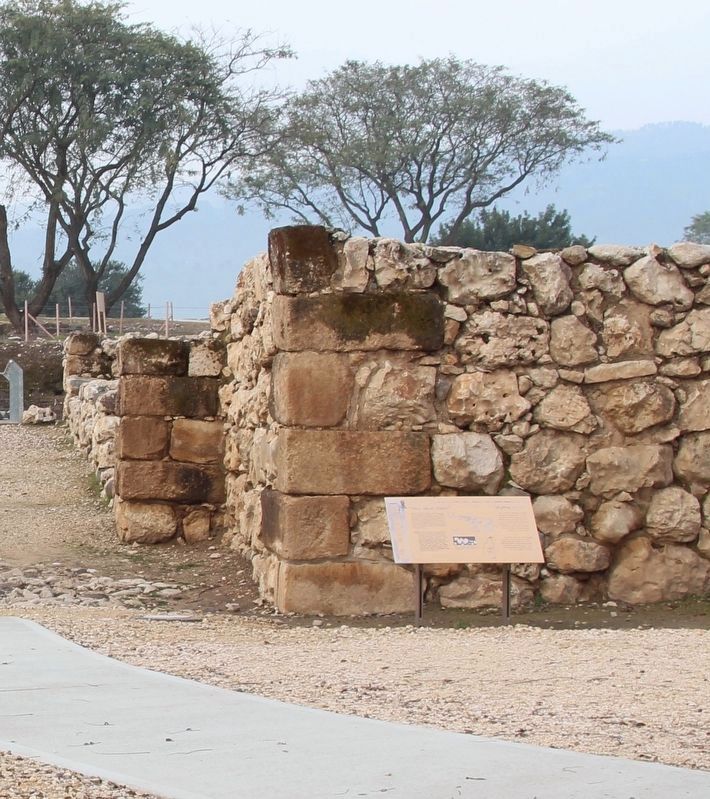
English Text:
Israelite Hazor, from the 10th century BCE (the time of the United Monarchy), included only the upper city. The area of the Israelite city extended over some 35 dunams, and its inhabitants numbered between 1,000 and 1,500. . . . — — Map (db m141415) HM
Near Rosh Pina - Metulla Road just east of Northern District Route 90, on the left when traveling east.
English Text:
This palace, which served the kings of Hazor during the 14th-13th centuries BCE, is of a ceremonial nature (The administrative palace is to be sought elsewhere on the site). The plan, consisting of a courtyard and a throne . . . — — Map (db m141407) HM
Near Rosh Pina - Metulla Road just east of Northern District Route 90, on the left when traveling east.
English Text:
The story of Hazor is represented by 21 layers of settlement. The history of Hazor can be divided into two chapters: Canaanite Hazor and Israelite Hazor.
Canaanite Hazor
You are now in the upper city and . . . — — Map (db m141417) HM
Near Rosh Pina - Metulla Road just east of Northern District Route 90, on the left when traveling east.
English Text:
The biblical tels of Hazor, Megiddo, and Beer Sheba were inscribed in 2005 by the United Nations Educational, Scientific and Cultural Organization (UNESCO) as World Heritage Sites with outstanding universal value. They are . . . — — Map (db m141414) HM
Near Rosh Pina - Metulla Road just east of Northern District Route 90, on the left when traveling east.
English Text:
Constructed during the reign of King Ahab (the 9th century BCE), it was designed to supply the inhabitants of the city with water in times of siege. A vertical shaft was dug through the earlier occupation layers, at the . . . — — Map (db m141421) HM
Near Israel National Trail just north of Northern District Route 99, on the right when traveling north.
English Text:
The entrance gate to Dan from the time of the Israelite Kingdom.
– Gate chamber
– Canopied structure for a king or a judge
– Paved, outer piazza for chariots
English Text on Marker . . . — — Map (db m141428) HM
Near Israel National Trail just north of Northern District Route 99, on the right when traveling north.
English Text:
And when Abram heard that his brother was taken captive, he led forth his trained men, born in his house, three hundred and eighteen, and pursued them as far as Dan.
Genesis 14:14
Exterior entry . . . — — Map (db m141448) HM
Near Israel National Trail just north of Northern District Route 99, on the right when traveling north.
English text:
This gate which was approached on a stepped path, is built of three arches. The arches, the piers supporting them, and the towers flanking the gate are constructed of sun-baked bricks and were covered with white plaster. . . . — — Map (db m141441) HM
Near National Route 99 just east of Route 999, on the left when traveling north.
English Text:
Nemesis was the goddess of vengeance and Roman imperial justice. Her long and narrow court was built in 178 CE in front of a great niche in which her statue was placed. A Greek inscription above the niche mentions the names . . . — — Map (db m64781) HM
Near National Route 99 just east of Farm to Market Road 999, on the left when traveling north.
English Text:
The stepped and paved courtyard on which you are standing was built in the mid-first century CE. An artificial cave was quarried in the cliff-face opposite the courtyard, and there the statue of Pan was placed. Pagan . . . — — Map (db m64754) HM
Near National Route 99 just east of Local Route 999, on the left when traveling north.
English Text:
The cave is the nucleus beside which the sacred sanctuary was built. In this "abode of the shepherd god," pagan cult began as early as the 3rd century BCE. The ritual sacrifices were cast into a natural abyss reaching the . . . — — Map (db m64738) HM
Near National Route 99 just east of Local Route 999, on the left when traveling north.
English Text:
The conquests of Alexander the Great (3rd c. BCE) brought the Greeks to the East, and to Banyas. The Greeks were taken by the natural beauty of the site, touched particularly by the cave in which the springs welled. It is . . . — — Map (db m64764) HM
Near National Route 99 just east of Local Route 999, on the left when traveling north.
English Text:
Built in 19 BCE, during the reign of Herod the Great, in honor of the Roman Emperor Augustus. The coin at the top of this text, shows the facade of the temple. In front of you is the western wall of the hall with semicircular . . . — — Map (db m65177) HM
Near National Route 99 just east of Local Route 999, on the left when traveling north.
English Text:
This structure was built around 220 CE. Only parts of this temple survived. Among them are the north wall, part of a semicircular hall (apse), and a semicircular niche behind it. This same structure is depicted on the . . . — — Map (db m141468) HM
Near National Route 99 just east of Route 999, on the left when traveling north.
English Text:
Built around 96 CE in the days of Emperor Trajan, for the city's 100th anniversary. A marble inscription found at the site implies that it was a temple for Pan and for Zeus of Heliopolis (the city of Ba'albek). Only the . . . — — Map (db m64768) HM
Near National Route 99 just east of Local Route 999, on the left when traveling north.
English Text:
This building was erected around 220 CE, in the days of Emperor Elagabalos. The bones of goats that took part in the rituals were buried in the rectangular niches in the main hall, together with offerings of pottery, glass . . . — — Map (db m141458) HM