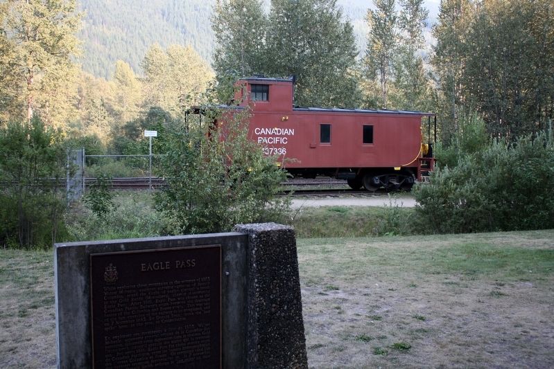
Near Trans-Canada Highway (Provincial Highway 1) 0.8 kilometers north of Lybarger Road, on the right when traveling north.
[English] While exploring these mountains in the summer of 1865, Walter Moberly, assistant surveyor-general of British Columbia, noted the flight of eagles through a break in the Gold Range (Monashees), thereby discovering Eagle Pass. After . . . — — Map (db m198549) HM
Near Trans-Canada Highway (Provincial Highway 1) 0.8 kilometers north of Lybarger Road, on the right when traveling north.
A nebulous dream was a reality: an iron ribbon crossed Canada from sea to sea. Often following the footsteps of early explorers, nearly 3000 miles of steel rail pushed across vast prairies, cleft lofty mountain passes, twisted through canyons, and . . . — — Map (db m187955) HM
Near Trans Canada Highway (Route 1) west of Whispering Wood Lane.
[English]
Baldwin #7717 Steam Locomotive
This Baldwin 2-6-0 mogul steam engine – builders #7717 – road #6 – 36" gauge locomotive, was built for the North Western Coal & Navigation Co. in 1885. It was originally used . . . — — Map (db m44339) HM
On Transcanada Highway (National Route 1), on the right when traveling west.
First recorded in the report of the Palliser expedition of 1857-60, this pass takes its name from an incident in which Dr. James Hector, surgeon in the expedition, was kicked by his horse while exploring in this vicinity. The pass was virtually . . . — — Map (db m74545) HM
Near Trans-Canada Highway (Provincial Highway 1) at Field Access Road.
[English] Take a look across the river. A century ago, an elegant hotel dominated this view. Now just a memory, Mount Stephen House was the first in a series of “Grand Hotels” built by the Canadian Pacific Railway. The CPR . . . — — Map (db m203580) HM
Near Trans-Canada Highway (Provincial Highway 1) at Field Access Road.
[English] In 1901, Mount Stephen Reserve was enlarged and became Yoho Park Reserve. The following year, Mount Stephen House was also expanded and now featured a rotunda, a huge dining room, a theatre and 60 rooms. Word got out . . . — — Map (db m203581) HM
Near Trans-Canada Highway (Provincial Highway 1) at Field Access Road.
[English] It was not my intention to have passed any great time at Field, yet I was detained there by the force of its attraction… the views from Field are fine and the excursions that can be made in the neighbourhood are . . . — — Map (db m203582) HM
Near Golden View Road, 0.2 kilometers south of Lafontaine Road, on the right when traveling south.
The first Sikhs arrived in Golden in 1902 to work in the mill of the Columbia River Lumber Company. Their Gurdwara (temple), one of the earliest in BC, became a focus of cultural identity and religious ceremony for the Sikh community.
Their . . . — — Map (db m188006) HM
Near Trans-Canada Highway (Provincial Highway 1) 11.5 kilometers east of Provincial Highway 95, on the left when traveling east.
Naming the Kicking Horse In the mid-1850s, an expedition was sent out by the Imperial Government to locate a feasible route west through the Canadian Rockies that would give good access to settlers in search of rich farming soil and . . . — — Map (db m203579) HM
Near Big Bend Highway (Provincial Highway 23) 2.6 kilometers north of Pearkes Drive, on the left when traveling north.
For 1200 miles, in two countries, the Columbia carves its way to the Pacific Ocean. Named after Robert Gray's ship the "Columbia", it was first mapped in 1811 by David Thompson. This "highway" for traders, missionaries and gold miners later became a . . . — — Map (db m187966) HM
Near Trans-Canada Highway (Provincial Highway 1) 85 kilometers west of Provincial Highway 95.
A ninety room hotel complete with bowling alley and observation tower once stood in this quiet clearing!Operated by the Canadian Pacific Railway from 1887 to 1925, it was used as a base by mountaineers, adventurers and sightseers from all over the . . . — — Map (db m108665) HM
On Trans-Canada Highway (Provincial Highway 1), on the right when traveling east.
For many years steam locomotives on the mainline of the Canadian Pacific Railway rumbled across these stone pillars.
Construction of the railway through these rugged mountains was a constant struggle. In this area, steep-sided valleys and . . . — — Map (db m110556) HM