3 entries match your criteria.
Related Historical Markers
Early History of the Nansemond Indian Tribe.
By Laura Troy, September 23, 2007
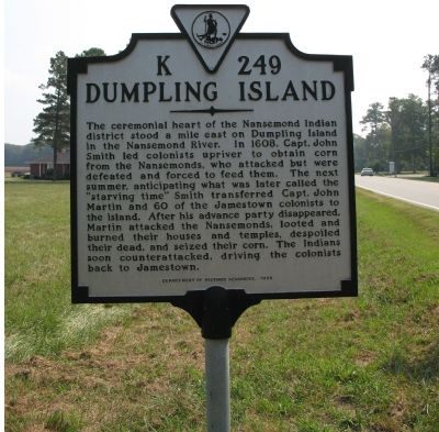
Dumpling Island Marker
SHOWN IN SOURCE-SPECIFIED ORDER
| On Goodwin Boulevard (Route 10) 0.4 miles north of Harrell Drive, on the right when traveling north. |
| | The ceremonial heart of the Nansemond Indian district stood a mile east on Dumpling Island in the Nansemond River. In 1608, Capt. John Smith led colonists upriver to obtain corn from the Nansemonds, who attacked but were defeated and forced to feed . . . — — Map (db m2671) HM |
| On Godwin Boulevard (Virginia Route 10) at Everets Road (County Route 603), on the right when traveling south on Godwin Boulevard. |
| | The principal villages of the Nansemond Indians stood just east of here on the Nansemond River. The Nansemonds fought frequently with the English colonists who arrived in 1607 as the Indians resisted the newcomers’ attempts to occupy their villages . . . — — Map (db m162966) HM |
| On East 3rd Street (U.S. 20) near 3rd Avenue, on the right when traveling west. |
| | Redwood Water Tank was built to furnish water for the Fremont, Elkhorn, Missouri Valley Railroad steam engines. This line which was part of the Northwestern Line and later became the Chicago Northwestern Railroad that came to Lusk on July 13, 1886. . . . — — Map (db m98289) HM |
May. 6, 2024