Near Plank Road / Germania Highway (State Highway 3), on the right when traveling west.
April 27-May 6, 1863. Leaving a large detachment under Sedgwick in front of Fredericksburg, Hooker marched a flanking column around and behind the Confederates. Lee then left a small unit to face Sedgwick and advanced westward to meet Hooker. . . . — — Map (db m3517) HM
On McLaws Drive, 0.1 miles south of Plank Road / Germania Highway (Virginia Highway 3), on the right when traveling south.
May 1-3, 1863. "Our enemy must either ingloriously fly or come out from behind his entrenchments and give us battle on our own ground, where certain destruction awaits him." With these words, "Fighting Joe" Hooker, on May 1, started toward the rear . . . — — Map (db m3559) HM
On Jackson Trail West at Brock Road (County Route 613), on the left when traveling north on Jackson Trail West.
May 2, 1863. The head of Jackson's column reached this point about 12:30 p.m. Eight miles away, the rear , under fire of Federal guns, was closing up near the Catharine Furnace. Jackson planned to turn the column right onto the Plank Road (1 mile . . . — — Map (db m3934) HM
On Plank Road / Germania Highway (State Highway 3), on the right when traveling west.
(South Face): On this Spot fell mortally wounded Thomas J. Jackson Lt. Gen. C.S.A. May 2nd 1863 (East Face): There is Jackson standing like a stone wall Bee at Manassas. (North Face): Could I have directed events, I should have chosen for the good . . . — — Map (db m3975) HM
On Stuart Drive, on the right when traveling south.
On the morning of May 3, this large, open plateau, known as "Hazel Grove," was the key to the Union position. "Stonewall" Jackson's flank attack the evening before had staggered the Union army but had not seriously damaged it. As the new day . . . — — Map (db m3610) HM
On Plank Road (State Highway 3) at Elys Ford Road (County Route 610), on the right when traveling west on Plank Road.
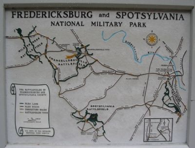
The intersection in front of you was the focal point of the Chancellorsville Battlefield. From here roads radiated in five directions. Four of them are visible; the fifth, River Road, lies just beyond the trees to your left. From this . . . — — Map (db m3800) HM
On Elys Ford Road (County Route 610) at Bullock Road, on the right when traveling south on Elys Ford Road.
The low earthworks opposite are the apex of the final Union line at Chancellorsville. After suffering defeat in the massive fighting on May 3, Hooker's army started digging. The result: a powerful, U-shaped line six miles long supported by 100 . . . — — Map (db m3691) HM
Near Old Salem Church Road near Plank Road (Virginia Route 3).
Spotsylvania Baptists built this church in 1844 and named it Salem, a Biblical word meaning peace. Two decades later, Salem Church was engulfed by war. Initially the church had just 29 members, but by 1859 the number had risen to 77, 20 of whom . . . — — Map (db m3503) HM