7 entries match your criteria.
Related Historical Markers
To better understand the relationship, study each marker in the order shown.
By Dale K. Benington, August 4, 2010
Tecumseh Marker
SHOWN IN SOURCE-SPECIFIED ORDER
| On Tecumseh Road (Ohio Route 369) north of Lower Valley Pike, on the right when traveling north. |
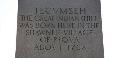
| | [Front Side of Marker]
Here
General
George Rogers
Clark
With his Kentucky soldiers
Defeated and drove
From this region
The Shawnee Indians
August 8 1780
Thus aiding to make
The Northwest Territory
Part of the . . . — — Map (db m35379) HM |
| Near Tecumseh Road (Ohio Route 369) 0.2 miles north of Ohio Route 4. |
| | Before you lay Piqua, or Picawey, a Shawnee settlement where 1,000 Kentucky militiamen under Col. George Rogers Clark defeated an alliance of Shawnee, Delaware, Mingo and Wyandot warriors on August 8, 1780 in the largest battle fought west of the . . . — — Map (db m34207) HM |
| On Tecumseh Road (Ohio Route 369) at Lower Valley Pike, on the right when traveling north on Tecumseh Road. |
| | Approximately three miles west of Springfield at the present site of George Rogers Clark Memorial Park lay the Shawnee Indian Town called Piqua. This town was the site of the battle of Piqua on August 8th, 1780 - one of the last battles of the . . . — — Map (db m35171) HM |
| On Tecumseh Road (Ohio Route 369) at Lower Valley Pike, on the right when traveling north on Tecumseh Road. |
| | The Shawnee village of Peckuwe stood on this site until August 8, 1780. This village was inhabited by the Peckuwe and Kispoko Divisions of the Shawnee Tribe.
The Shawnee, along with the other tribes in Ohio, often placed a large cedar pole in . . . — — Map (db m35274) HM |
| Near Tecumseh Road (Ohio Route 369) north of Lower Valley Pike. |
| | "In memory of those men who died in
the Battle of Piqua, August 8, 1780,
the largest Revolutionary War battle
West of the Alleghenies." — — Map (db m35288) HM |
| On Tecumseh Road (Ohio Route 369) north of Ohio Route 4. |
| | Statesman, Warrior and Patriot was born March 1768, three miles west of Springfield, close to Route 40 - State Route 369 - at the Shawnee Indian Town called Piqua. Site of the battle of Piqua, August 8th, 1780, presently George Rogers Clark Memorial . . . — — Map (db m35123) HM |
| On Tecumseh Road (Ohio Route 369) north of Lower Valley Pike. |
| | Within this park and immediate vicinity, former site of the Shawnee Indian Village of Piqua. The Shawnees and their British Allies were defeated by General George Rogers Clark with his army of Kentucky Frontiersmen. This battle greatly advanced the . . . — — Map (db m35295) HM |
May. 19, 2024