in Wisconsin’s transportation system is the Port of Green Bay. It serves as a multi-modal distribution center connecting waterborne vessels with an extensive network of highways and railroads. The Port of Green Bay provides Northeast Wisconsin . . . — — Map (db m43812) HM
to many people for thousands of years before the first Europeans arrived. The rich waters of the bay attracted a number of American Indian Tribes - all members of a large and complex trading network stretching throughout North America.
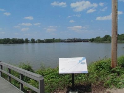
Green . . . — — Map (db m43813) HM
is the most cost-effective mode of transportation when compared to truck or rail. Ships quietly move cargo farther (per ton mile) and more efficiently than trucks or trains. Most importantly, ships move cargo more safely than trucks and trains. . . . — — Map (db m43814) HM
as well as Fort Crawford at Prairie du Chien, was built following the War of 1812 to establish a U.S. presence in the Wisconsin territory and strategically cut off British access to trade routes. The forts were also used to construct Wisconsin's . . . — — Map (db m43816) HM
is a vital part of our local economy, our history and our lives. It plays an important role in the transportation of goods and commodities that are critical to the economic health of the region. The Port of Green Bay receives and/or sends . . . — — Map (db m43817) HM
and the Fox River Trail is the tomb of Dr. William Edward Minahan, who died in the sinking of the Titanic. William had four brothers who were also doctors, and his oldest brother, Robert, was also a lawyer who served as mayor of Green Bay from . . . — — Map (db m43818) HM
and geographic location is everything. The sparkling waters of Green Bay and sweeping rivers feeding into it
have attracted numerous industries over the past few hundred years. The French fur-trading empire of the
early 1700s gave way to . . . — — Map (db m43819) HM
Fort Howard commander Colonel Joseph Smith moved the garrison to near this location, about a half-mile back from the shore. The high ridge on which the camp,
dubbed “Camp Smith,” was located provided good visibility and protection . . . — — Map (db m43820) HM
The Chicago, Milwaukee and St. Paul Railroad…
later known as the Milwaukee Road came to Green Bay in 1873.
This depot was built in 1898 and was the only passenger depot located on the east side of the river. It served as a . . . — — Map (db m43821) HM
was appointed by President Monroe as a district judge for the northern and western Michigan Territory, which included what is now the state of Wisconsin. Doty set up the region's new court in an empty log building.
Three years later, . . . — — Map (db m43822) HM
The Roi-Porlier-Tank Cottage… has an extraordinary rich history in Green Bay, as it was home to a fur trader, schoolmaster, judge and missionary.
In 1803, a French Canadian fur trader by the name of Joseph Roi built the small cottage . . . — — Map (db m241106) HM
of the Morgan L. Martin family for 100 years (1837-1937). Martin was a prominent Green Bay attorney, civic leader, Indian agent and entrepreneur, originally from upstate New York, who helped lay the foundation for Wisconsin's statehood. In 1848, . . . — — Map (db m37204) HM
853 feet north 45 degrees, 7 minutes east, from this tablet, stands a flag pole, marking the southeast corner of the stockade of Fort Howard; occupied by United States troops August 1816, and almost continuously until 1852. On this site also stood . . . — — Map (db m100952) HM
Major Zachary Taylor served as commandant of Fort Howard for nearly three years, arriving in the spring of 1817 with 500 men of the fifth United States Infantry.
He would become the twelfth president of the United States on the fifth of . . . — — Map (db m202937) HM