5 entries match your criteria.
Related Historical Markers
To better understand the relationship, study each marker in the order shown.
By Dale K. Benington, July 10, 2014
The Battle of Big Sandy Marker
SHOWN IN SOURCE-SPECIFIED ORDER
| Near New York State Route 3 north of Nash Road, on the left when traveling north. |
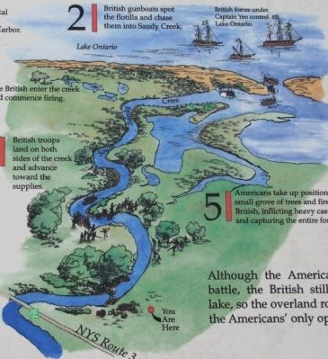
| | Americans Set An Ambush
An American flotilla carrying critical shipbuilding supplies to Sackets Harbor was forced to land along South Sandy Creek. Near this spot Major Appling's 120 riflemen, 150 Oneida Indian warriors and naval . . . — — Map (db m75733) HM |
| On New York State Route 3, 0.1 miles south of South Landing Road, on the right when traveling south. |
| | After the Battle of Big Sandy May 28, 1814 this house was used as a hospital for British soldiers — — Map (db m70475) HM |
| On New York State Route 289 at Lee Road, on the right when traveling north on State Route 289. |
| | Route traveled by the men
who carried the four-ton cable
for the ship "Superior" twenty miles
from Sandy Creek Battlefield
to Sackets Harbor in June 1814. — — Map (db m86186) HM |
| On Butterville Road (County Route 75) north of John's Lane, on the left when traveling north. |
| | Route traveled by the men who carried the four-ton cable for the ship "Superior" twenty miles from Sandy Creek Battlefield to Sackets Harbor in June 1814. — — Map (db m86193) HM |
| On Smithville Road (County Route 75) north of New York State Route 3, on the right when traveling north. |
| | Route traveled by the men
who carried the four-ton cable
for the ship "Superior" twenty miles
from Sandy Creek Battlefield
to Sackets Harbor in June 1814. — — Map (db m86204) HM |
May. 2, 2024