Marker Logo HMdb.org THE HISTORICAL
MARKER DATABASE
“Bite-Size Bits of Local, National, and Global History”


5 entries match your criteria.  


Related Historical Markers

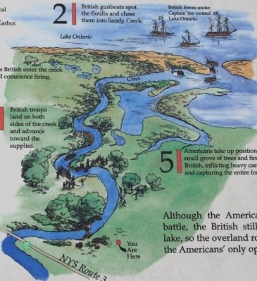
To better understand the relationship, study each marker in the order shown.
 
The Battle of Big Sandy Marker image, Touch for more information
By Dale K. Benington, July 10, 2014
The Battle of Big Sandy Marker
SHOWN IN SOURCE-SPECIFIED ORDER
1 New York, Jefferson County, Ellisburg — The Battle of Big SandyMay 30, 1814 — War of 1812 —
Near New York State Route 3 north of Nash Road, on the left when traveling north.
2 New York, Jefferson County, Ellisburg — After the Battle of Big Sandy
On New York State Route 3, 0.1 miles south of South Landing Road, on the right when traveling south.
3 New York, Jefferson County, Ellisburg — Carrying Cable Route
On New York State Route 289 at Lee Road, on the right when traveling north on State Route 289.
4 New York, Jefferson County, Belleville — Carrying Cable Route
On Butterville Road (County Route 75) north of John's Lane, on the left when traveling north.
5 New York, Jefferson County, Sackets Harbor — Carrying Cable Route
On Smithville Road (County Route 75) north of New York State Route 3, on the right when traveling north.


CeraNet Cloud Computing sponsors the Historical Marker Database.
This website earns income from purchases you make after using our links to Amazon.com. We appreciate your support.
Paid Advertisement
May. 17, 2024