7 entries match your criteria.
South Carolina, Greenville County Historic Preservation Commission Historical Markers
By Brian Scott, February 7, 2011
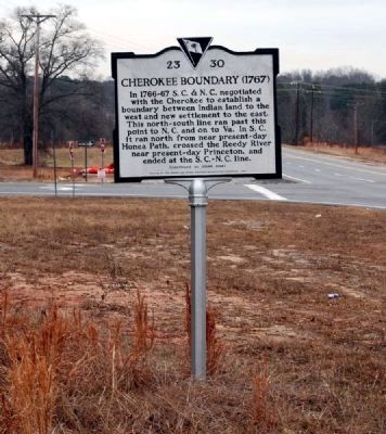
Cherokee Boundary (1767) Marker -
Front
| On McCarter Drive (State Highway 418) west of Interstate 385, on the right when traveling west. |
| On Duckett Street at Mount Zion Drive (County Road 89) on Duckett Street. |
| On Hickory Tavern Road south of County Road 301, on the left when traveling north. |
| On South Highway 14 (State Highway 14), on the left when traveling north. |
| On City Century Drive, in the median. |
| On Augusta Road (U.S. 25). Reported missing. |
| On North Tigerville Road at Route 414 on North Tigerville Road. |
May. 5, 2024