The southern end of the
97-mile canal (1837-78) was
at the river confluence. It moved
Pa coal, local lumber
& goods to the Erie Canal.
Canal Society
of NYS — — Map (db m92919) HM
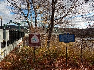
Historic
North Side
The Chenango Canal
Between 1837 and 1875 the
canal linked Binghamton
and Utica. Its general course
followed the line of State
St. which is built on the
filled in canal bed. — — Map (db m93029) HM
Built by Cornelius & Barbara Bevier circa 1850. Purchased 1889 by Otsego County native & Civil War veteran William Wright for 3,000.00. W. E. Wright was a carpenter, general contractor & proprietor of two stove & tinware stores in Binghamton. . . . — — Map (db m94390) HM
The stone walls visible here are parts of Lock 107 on the Chenango Canal, which opened in 1837. Constructed as a composite lock of stone lined with wooden planks, Lock 107 was repaired and rebuilt several times over the years. The last rebuild of . . . — — Map (db m94370) HM
The Chenango Canal was part of a vast network of canals that connected New York State's cities with the Great Lakes, the Hudson River and the Atlantic Ocean. Opened for navigation on May 6, 1837, the Chenango Canal carried people between the Erie . . . — — Map (db m94410) HM
The valleys of the Upper Susquehanna River were natural routes for Indians, traders and settlers. Oquaga, near Windsor, was an Indian fur-trading post, and became an objective of the Sullivan-Clinton Campaign of 1779. From a dam at the outlet of . . . — — Map (db m35164) HM
Canal bridge site where 1,000 men of the 114th Regt. embarked by flotilla to Civil War, Sept. 6, 1862.
Bicentennial '76
NB&T of Norwich — — Map (db m92593) HM
East of the road are remains of a lock and feeder pond where canal passed through productive farm country.
Bicentennial '76
Terry Descendants — — Map (db m92595) HM
This view of the Chenango Canal is looking north toward the Maydole Hammer factory and Lock #93. The Hammer factory covered the area today (2007) occupied by the buildings of the Golden Age Apartments. The lock was located in the space that is now . . . — — Map (db m94231) HM
This photograph taken from the west bank of the Chenango Canal looking east, shows the Sternberg, Hall and Company Sash and Blind Factory. The picture of the factory was taken about 1872. The factory produced window frames (sashes) and blinds . . . — — Map (db m94233) HM
This photograph taken about 1870 shows the Chenango Canal looking south from the viewpoint of the canal bridge that crossed East Main Street at Canal Street. In the foreground is Edwin Smith's Warehouse, later known as R.D.Eaton Grain and Seed . . . — — Map (db m94236) HM
The Chenango Land Trust expresses its graditude Maurice and Barbara Ingraham for having the foresight to protect Chenango Canal Lock 99,the best preserved Chenango Canal lock, Lock purchase and preservation made possible by a grant from the Land . . . — — Map (db m93513) HM