Chickamauga and Chattanooga National Military Park: November 24, 1863 Historical Markers
The Confederate markers, monuments, and tablets that are included in the National Park Service’s “List of Classified Structures,” for the units that were part of the military action on November 24, 1863.
On Point Park Road, 0 miles north of East Brow Road.
The night before the Battle Gen. Stevenson was assigned to command the Confederate line from Chattanooga Creek to the extreme left on Lookout Mountain, a distance of 15 miles. Stevenson’s Division, of Brown’s, Cummings and Pettu’s Brigades then . . . — — Map (db m23187) HM
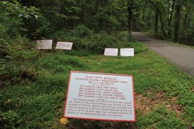
On Shingle Road north of Lookout Mountain Scenic Highway (Tennessee Route 148), on the left when traveling north.
[Text from the First Tablet]:
Stevenson's Division - Breckinridge's Corps.
Maj. Gen. Carter L. Stevenson.
Nov. 24, 1863
Brown's Brigade - Brig. Gen. John C. Brown.
Cumming's Brigade - Brig. Gen. . . . — — Map (db m68850) HM
Stevenson's Division - Breckinridge's Corps.
Maj. Gen. Carter L. Stevenson.
Nov. 24, 1863
Brown's Brigade - Brig. Gen. John C. Brown.
Cumming's Brigade - Brig. Gen. Alfred Cumming.
Pettus' Brigade - Brig. Gen. Edmund W. . . . — — Map (db m58811) HM