To your left is Canaan Baptist Church. Its relocation here from Georgia Avenue in 1963 was the fulfillment of pastor Rev. M. Cecil Mills's dream to preside over the first African American church on this avenue of churches. The congregation . . . — — Map (db m130869) HM
Around 1900 this successful suburb attracted successful business leaders, who set a grand standard for home building. Printer Byron S. Adams commissioned architect Frederick Pyle to design 1801 Park Road in the Colonial Revival style. Pyle . . . — — Map (db m130876) HM
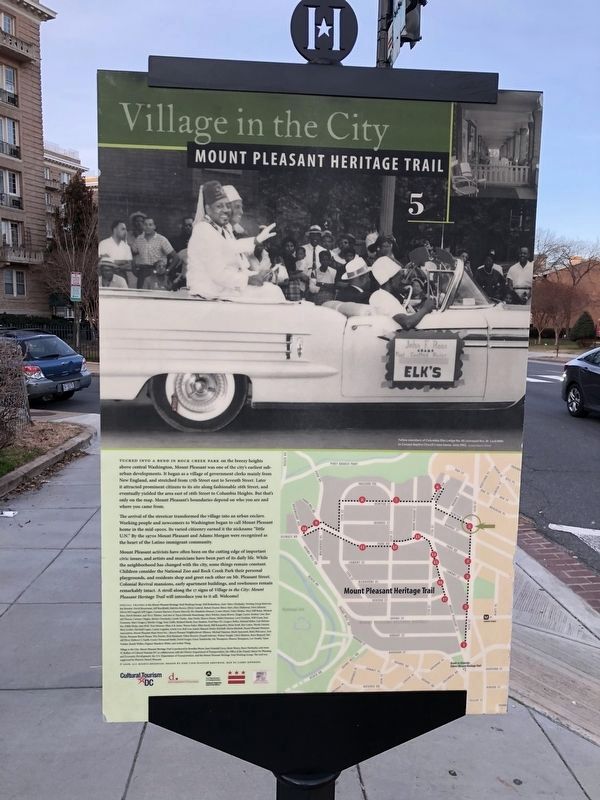
Like the Latino immigrants of recent times, Europeans left the political and economic hardships of home for a better life in the United States. Following the 1948 communist coup of Czechoslovakia a "Czech Row" or "Prague Road" enclave . . . — — Map (db m152976) HM
In 1948 the U.S. Supreme Court ruled that covenants prohibiting the sale of houses to individuals of certain races could not be enforced. Two years later, Dr. Robert Deane became the first African American to purchase a house in Mount . . . — — Map (db m130875) HM
Today's 16th Street from the White House to Silver Spring, Maryland is one of the city's key gateways. But through the 1890s it jogged left where Mt. Pleasant Street runs today and then dead-ended at the edge of today's Rock Creek Park. . . . — — Map (db m130861) HM
In 1903 a street car line arrived on Mt. Pleasant Street and so did new businesses. In this block were Sophia Weiss's notions shop, Domenico Pappalardo's shoe shop, and Lee Sing's laundry. The block's first commercial building (3215) was . . . — — Map (db m130880) HM
When the Mount Pleasant Library, behind you, opened in 1925, crowds flocked to the Classical style building. Many had campaigned long and hard for this community centerpiece. The Carnegie Corporation, funder of public libraries in Mount Vernon . . . — — Map (db m130864) HM
Set back from the street at 1621 Park Road, to your left, is an elegant old house, once the all-girls Sacred Heart Academy. The Sinsinawa Dominican Sisters of Wisconsin founded the Academy in 1905 and went on to operate it with Sacred Heart . . . — — Map (db m130865) HM
Lamont Park, across from the number 42 bus stop, was once the turnaround for the numbers 40 and 42 streetcars. Back in the 1940s, "when the conductor called 'end of the line,' passengers stepped onto a yellow wooden platform," recalled former . . . — — Map (db m130881) HM
The 1960s saw this neighborhood develop a Latino presence, and this became its Main Street. The storefront at 3161 Mt. Pleasant Street once housed Casa Diloné , the first bodega (grocery) here. From 1962 until 1998, Casa Diloné sold . . . — — Map (db m130882) HM
Ingleside, the grand house to your left, once anchored a 139-acre estate. Thomas Ustick Walter (1804-1887), architect of portions of the U.S. Capitol, designed Ingleside in 1851. Today it is Mount Pleasant's oldest structure.
New York . . . — — Map (db m184985) HM
Harry Townsend, who passed away at the age of 102 in 2004, had lived in the 1700 block of Kenyon Street since 1956. He was a well-known local figure who worked in construction. Townsend was still helping neighbors with repairs at age 90. . . . — — Map (db m179596) HM
Just like Mount Pleasant, Bancroft School is known for its ethnic and racial diversity. "at one of the spring fairs in the early 1970s, we asked people to bring native dishes, and I bought 27 little flags to mark the food," parent Gloria . . . — — Map (db m130872) HM
Beginning in the late 1950s, the community leadership of Mount Pleasant changed from the exclusive Citizens Association to an array of new players. Mount Pleasant Neighbors Association was the first alternative group. It presented festivals and . . . — — Map (db m148598) HM
This was the western edge of Samuel P. Brown's Mount Pleasant Village. Across the street and a few steps ahead at 3423 Oakwood Terrace is "Oakwood," an original village house built in 1871 for city politician J.W. Buker. Brown reserved the . . . — — Map (db m130870) HM
This secluded building on the edge of Rock Creek Park was built in 1911 as the House of Mercy. It provided, as its founders wrote "a refuge and reformatory for outcast and fallen women," especially unwed mothers and girls entangled in . . . — — Map (db m130874) HM
The mansion of Samuel P. Brown, Mount Pleasant's founder once stood in the middle of the block to your left. During the Civil War, Brown bought 73 acres here for a song from William Selden, a former U.S. treasurer. Selden believed the . . . — — Map (db m130877) HM