Referencing George Washington’s diaries, the Rev. Arthur P. Gray in 1938 traced the routes Col. Washington took on horseback between Fredericksburg and Williamsburg to attend colonial Virginia’s House of Burgesses during the 17 years he was the elected burgess from his district. The most often-used routes were 90-some miles long, one via New Kent and the other via West Point. While no markers currently mark the route, a number of markers reference courthouses, churches, homes and inns noted by Rev. Gray that Col. Washington passed by or where he spent the night, or longer. Those are the markers in this series.
On North Main Street (Virginia Route 2) at Courthouse Lane, on the right when traveling south on North Main Street.
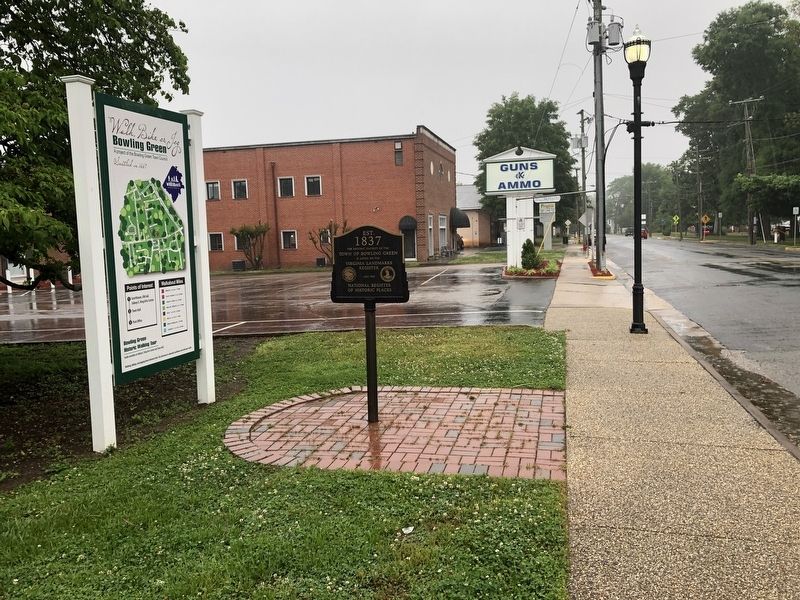
Est.
1837
The Historic District of the
Town of Bowling Green
is listed on the
Virginia Landmarks
Register
and the
National Register
of Historic Places — — Map (db m133743) HM
Near Stonewall Jackson Road (Virginia Route 606) near Guinea Station Road (Virginia Route 634).
The farm office across the lawn is all that remains of the once-sprawling plantation called “Fairfield.” Thomas Coleman Chandler purchased Fairfield Plantation in 1845. For the next 17 years it prospered and evolved – largely at . . . — — Map (db m5604) HM
On Richmond Road (U.S. 60) 0.7 miles south of Rochambeau Road (Virginia Route 30), on the left when traveling east.
Hickory Neck Church was built about 1740. Militia opposing the British camped here on April 21, 1781. A few miles north is the foundation of an ancient stone house, dating possibly from about 1650. — — Map (db m16848) HM
On The Trail (Virginia Route 14) at Frazier Ferry Road (Virginia Route 631), on the right when traveling south on The Trail.
A mile south on the Mattapony River is the site of Newington, birthplace of Carter Braxton, (born September 10, 1736), signer of the Declaration of Independence. In earlier times, Colonel Jacob Lumpkin, supporter of Governor Berkeley in Bacon's . . . — — Map (db m25260) HM
On Courthouse Road (Virginia Route 1301) at Horse Landing Road (Virginia Route 619), on the right when traveling west on Courthouse Road.
The King William County courthouse, erected early in the second quarter of the 18th century, is one of the older courthouses still in use in the United States. This T-shaped building was constructed of brick laid in Flemish bond, with an arcade . . . — — Map (db m25847) HM
On King William Road (Virginia Route 30) 0.1 miles east of Churchville Road (Virginia Route 630), on the right when traveling east.
This was the parish church of St. John's Parish, formed in 1680. It was built in 1734. Earlier churches stood at West Point and about one mile north of this site. Carter Braxton, Revolutionary Statesman, was a vestryman Preserved by joint effort. — — Map (db m25844) HM
On Eltham Road (Virginia Route 33) 0.1 miles south of Virginia Avenue, on the right when traveling south.
Eltham, a mile north, was long the home of the Bassett family and one of the largest and finest colonial houses in Virginia. Burwell Bassett, the owner at the time of the Revolution, was a patriot leader. Washington was a frequent visitor at Eltham . . . — — Map (db m21601) HM
About two miles northeast stood Chestnut Grove, the plantation home of John and Frances Jones Dandridge, where Martha Dandridge, the eldest of eight children, was born on 2 June 1731. She lived there until 15 May 1750, when she married Daniel Parke . . . — — Map (db m17740) HM
Near New Kent Highway at Courthouse Circle. Reported permanently removed.
Lord Cornwallis's army was here, moving eastward, June 22, 1781; Lafayette, in pursuit, June 25; Washington, Rochambeau and Chastellux, on their way to Yorktown, September 14, 1781. A part of Joseph E. Johnston's army, retiring to Richmond, passed . . . — — Map (db m17738) HM
On New Kent Highway at Old Church Road, on the right when traveling east on New Kent Highway.
Two miles northeast is St. Peter's Church, built in 1703 in English bond. David Mossom, rector there for forty years, was the minister who married George Washington. According to one tradition, the wedding took place at St. Peter's Church. — — Map (db m17728) HM
On New Kent Highway at Emmaus Church Road, on the right when traveling east on New Kent Highway.
This place, six miles northeast, was the home of Martha Custis. According to tradition, George Washington first met her at Poplar Grove, near by, in 1758. On January 6, 1759, Washington and Martha Custis were married, it is believed at the White . . . — — Map (db m17718) HM