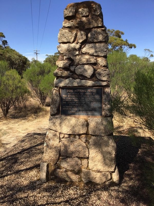
On Dog Netting Road, on the right when traveling north.
This plaque was erected by the Whycheproof Shire Council to commemorate the construction in 1885, of a fence from Tyntynder to the South Australian border, a distance of 204 miles, to prevent wild dogs and other vermin from entering farm lands to . . . — — Map (db m218783) HM
On Little Hopwood Street close to Murray Esplanade.
This Establishment Built About 1878 Is The Only Classified Brothel in Victoria
The house consists of 3 small rooms on each floor, the upper rooms being reached by a staircase leading into a sheltered lane running off Little Hopwood street, . . . — — Map (db m70630) HM
Near Nicholson Street close to Gertrude Street, on the left when traveling north.
This pillar of stone quarried from Stawell was placed here on the insistence of
The Hon. John Woods, M.P.
(born Liverpool England November 5th 1822, died Brighton Victoria April 2nd 1892; engineer, politician and inventor, commissioner . . . — — Map (db m70636) HM
On Midland Highway, on the left when traveling north.
Guildford Honor Row
Aberdeen J. • Annear L. • Bardi A. • † Binns A. • † Binns L. • † Binns P. • Brocchi S. • Carter F. • † Carter G. • † Carter J. • † Carty J. • Colgan E. • Cox H. • † Davidson R. • Davenport R. • Dell H. • Dell J. • Dewsnap . . . — — Map (db m45802) WM
Guildford The Big Tree is thought to be one of the largest examples of the species in Victoria. It has been recorded as having a height of 30m, a canopy spread of 34m, and trunk circumference of 9.35m. Estimates of the age of the tree range . . . — — Map (db m45968) HM
On High Street (County Route C282) close to Francis Street.
The Mechanics’ Institute movement began in British urban industrial centres in the early 1800s. A “mechanic” was a person applying skills and technology. During the 19th century, most towns in Victoria established a Mechanics’ Institute or Athenaeum . . . — — Map (db m71068) HM
Near Bendigo-Maldon Road close to Lewis Road, on the left when traveling north.
This bucket dredge was operated here by George Heywood, Eric Baumann and others, for about 30 years, until it was abandoned in 1984. It was one of the last dredges operated in Victoria.
It is a relatively small bucket dredge, but is one of few . . . — — Map (db m70631) HM
The Newfield
Three masted iron barque 1306 tons gross
Built Dundee Scotland 1889
Wrecked Newfield Bay 29 August 1892
The Newfield", with a crew of 26, left Sharpness, Scotland, on 28 May 1889, with a cargo of fine salt . . . — — Map (db m52642) HM
On Griffiths Island just east of Ocean Drive, on the left.
In Memory of Captain John Griffiths 1801 - 1881 This island is named after him and he was responsible for bringing the first White settlers from Launceston, Tasmania to Portland Bay and Port Fairy Victoria. He established the first major whaling . . . — — Map (db m52472) HM
On Gipps Street at Campbell Street on Gipps Street.
Top Marker
This memorial was unveiled
July 8 1934 by Mrs. C.A. Melhuish
daughter of
Captain Thomas Boyd
first master of the S.S. Casino.
Middle Marker
Borough of Port Fairy
This commemorative plaque is to . . . — — Map (db m83435) HM
On Esplanade at Schnapper Point Dve, on the left when traveling east on Esplanade.
In memory of fifteen young men lost in the bay off Mornington on the night of Saturday 21st May, 1892, while returning from a football match at Mordialloc.
Allchin, Charles E. (20 yrs) • Caldwell, James R. (21 yrs) • Caldwell, William L. (19 . . . — — Map (db m81713) HM
The schooner “Rosebud" from which the town Rosebud gets its name was blown ashore on this site on 2nd June, 1855. Press reports of weather conditions on this date indicate strong westerly gales, with several boats in distress on Port Phillip Bay. . . . — — Map (db m81588) HM
On Leggett Way close to Leggett Way, on the right when traveling west.
The people of the Bunerong lived in the Mornington Peninsula region for many thousands of years.
On 9 October, 1803 HMS "Calcutta" under the command of Captain Daniel Woodriff entered Port Phillip Bay carrying David Collins the Lieutenant . . . — — Map (db m81596) HM
This memorial is dedicated to all Aboriginal men and women from South West Victoria who served their country proudly along with fellow Australians since World War 1. — — Map (db m52646) HM
This stone commemorating the Foundation of Warrnambool
Gazetted on 17 February 1847
was unveiled by
His Excellency The Honourable Richard E. McGarvie A,C.
Governor of Victoria
in the presence of His Worship the Mayor Cr Gerald Shanley — — Map (db m52643) HM