Near New Berlin in Sangamon County, Illinois — The American Midwest (Great Lakes)
Potawatomi Trail of Death
Island Grove Encampment
— Sept 4-Nov 4, 1838 —
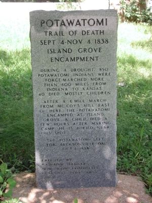
Inscription.
Trail of Death
Sept 4 - Nov 4, 1838
Island Grove
Encampment
During a drought, 850 Potawatomi Indians were force-marched more than 600 miles from Indiana to Kansas. 40 died, mostly children.
After a 6 mile march from McCoy's Mill east of here, the Potawatomi encamped at Island Grove. A child died a few hours after making camp. He is buried near this spot.
The Potawatomi left for Jacksonville on Oct 1, 1838.
Erected by
Rainbow Dancers
Pow Wow Committee
Clayville Folk Arts Guild
1995
Erected 1995 by Rainbow Dancers, Pow Wow Committee, Clayville Folk Arts Guild.
Topics and series. This historical marker is listed in these topic lists: Cemeteries & Burial Sites • Native Americans • Notable Events • Wars, US Indian. In addition, it is included in the Potawatomi Trail of Death series list. A significant historical year for this entry is 1838.
Location. 39° 45.819′ N, 89° 57.387′ W. Marker is near New Berlin, Illinois, in Sangamon County. Marker is on Old Jacksonville Road (County Route 8) 0.1 miles east of Peters Road (County Route 8), on the right when traveling west. This marker is located on the north side of the Old Jacksonville Road, approximately 1/4 mile west of the Woodwreath Cemetery/Island Grove Methodist Church. Touch for map. Marker is at or near this postal address: 16284 Old Jacksonville Road, New Berlin IL 62670, United States of America. Touch for directions.
Other nearby markers. At least 8 other markers are within 14 miles of this marker, measured as the crow flies. All Gave Some, Some Gave All (approx. 3.9 miles away); Clayville (approx. 7.8 miles away); Clayville Tavern (approx. 7.8 miles away); Peter Cartwright (approx. 8 miles away); a different marker also named Potawatomi Trail of Death (approx. 9˝ miles away); Colonel Ulysses S. Grant (approx. 9˝ miles away); Mentor Graham (approx. 13.8 miles away); New Salem (approx. 13.8 miles away). Touch for a list and map of all markers in New Berlin.
Also see . . .
1. Potawatomi Trail of Death map and additional information. Kansas Heritage entry (Submitted on July 2, 2010, by New Berlin Area Historical Society of New Berlin, Illinois.)
2. Potawatomi Trail of Death. Wikipedia entry. (Submitted on October 29, 2020, by Larry Gertner of New York, New York.)
Credits. This page was last revised on October 29, 2020. It was originally submitted on July 2, 2010, by New Berlin Area Historical Society of New Berlin, Illinois. This page has been viewed 1,859 times since then and 17 times this year. Photos: 1, 2. submitted on July 2, 2010, by New Berlin Area Historical Society of New Berlin, Illinois. • Kevin W. was the editor who published this page.

