Near Brookeville in Montgomery County, Maryland — The American Northeast (Mid-Atlantic)
The Rachel Carson Greenway
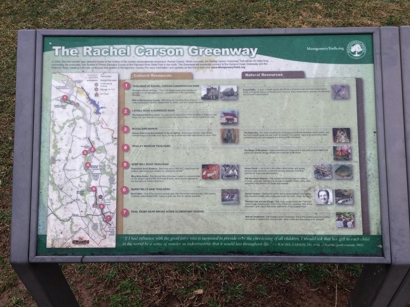
In 2004, this trail corridor was named in honor of the mother of the modern environmental movement, Rachel Carson. When complete, the Rachel Carson Greenway Trail will be 25 miles long, connecting the Anacostia Trail System in Prince George's County to the Patuxent River State Park in the north. The Greenway will eventually connect to the Seneca Creek Greenway and the Potomac River, creating a 50-mile continuous trail system in Montgomery County. For more information and updates as this trail is built visit: www.MontgomeryTrails.org.
1. Trailhead at Rachel Carson Conservation Park
• Our Agricultural Heritage - There has always been a rich tradition of agriculture in Montgomery County, now preserved in the Agricultural Reserve.
• Mills in Montgomery County - Mills along the Hawlings River stream valley turned grain into flower, sawed trees for timber, and wove fleece into wool.
• Forest Birds - A walk in these woods still affords a chance to see and hear forest interior birds, such as the Kentucky Warbler and Ovenbird. Many forest interior species are declining due to forest fragmentation.
2. Layhill Road & Norwood Road
• The Holland Red Door Store
this page online
3. Woodlawn Manor
• African Americans and Quakers in Sandy Spring - Encouraged by their regional and national Religious Society, most Sandy Spring Quakers had freed their slaves by about 1820.
• The Night Sky - For those traveling the Underground Railroad darkness meant safety, and the stars helped guide the way north to freedom. For wildlife, night is an active time when predators and prey are engaged in a drama for life and death.
4. Trolley Museum Trailhead
• The Magic of Meadows - Open meadows and hedgerows in the park provide habitat and plants and animals whose needs cannot be met in the forest.
5. Kemp Mill Road Trailhead
• Prehistoric Rock Shelters - Beginning about 1000 B.C., local American Indians used these rock shelters as "prehistoric motels."
• Mica Mine Ruins - The Gilmore Mica Mine was located in a wooded area on the western bank of the Northwest Branch, which now is adjacent to the Springbrook Forest subdivision.
• Vernal Pools - Low spots in the forest
• The Northwest Branch - This stream has flowed here for millions of years, gradually changing its course to create a stream valley that supports a rich diversity of plants and animals.
6. Burnt Mills Dam Trailhead
• Burn Mill - One of the county's earliest grist mills stood here starting in the 18th century. Originally called Bealle's Mill, it ground grain into flour for nearby residents.
• Rachel Carson - The famed author and environmentalist lived along this beautiful stream valley while she wrote her book, Silent Spring.
• The Fall Line and the Gorge - This rocky gorge marks the "Fall Line" where tough metamorphic rocks of the Piedmont, meaning "foot of the mountain," give way to the sandy sediments of the Coastal Plain.
7. Trail Kiosk Near Broad Acres Elementary School
• Natural Treasurers - The Rachel Carson Greenway Trail is the perfect place for children and adults to explore the natural world — take a hike and experience it for yourself.
"If I had influence with the good fairy who is supposed to preside over the christening of all children, I should ask that her gift to each child in the world be a sense of wonder so indestructible that it would last throughout life." — Rachel Carson, The Sense of Wonder (posthumously 1965)
Erected by Montgomery Parks.
Topics and series. This historical marker is listed in these topic lists: Abolition & Underground RR • African Americans • Agriculture • Parks & Recreational Areas. In addition, it is included in the Maryland, Montgomery Parks, and the Quakerism series lists. A significant historical year for this entry is 2004.
Location. 39° 13.187′ N, 77° 5.13′ W. Marker is near Brookeville, Maryland, in Montgomery County. It can be reached from Zion Road south of Sundown Road, on the right when traveling north. On the grounds of Rachel Carson Conservation Park. Touch for map. Marker is at or near this postal address: 22225 Zion Road, Brookeville MD 20833, United States of America. Touch for directions.

Regionally, this marker is in the Washington Metropolitan Area. It is also in the American Mid-Atlantic. Globally, it is in North America, the Western Hemisphere, the Western World, and the Anglosphere. Historically, it finds itself in what was once one of the original Thirteen Colonies and also the Antebellum South.
Other nearby markers. At least 8 other markers are within 3 miles of this marker, measured as the crow flies: Mills in the Upcounty (here, next to this marker); Our Agricultural Heritage (here, next to this marker); Howard Chapel Cemetery (approx. 1.6 miles away); Freedmen during Reconstruction in Montgomery County (approx. 2.8 miles away); Oakley Cabin (approx. 2.9 miles away); Newlin’s Mill (approx. 3 miles away); The Miller's Cottage (approx. 3 miles away); Bentley House (approx. 3 miles away). Touch for a list and map of all markers in Brookeville.
Other markers no longer nearby. Elton (was approx. 1.4 miles away but has been confirmed missing); Brookeville Schoolhouse (was approx. 2.9 miles away but has been permanently removed).
Credits. This page was last revised on December 14, 2022. It was originally submitted on February 25, 2018, by Devry Becker Jones of Washington, District of Columbia. This page has been viewed 497 times since then and 40 times this year. Photos: 1, 2. submitted on February 25, 2018, by Devry Becker Jones of Washington, District of Columbia. • Bill Pfingsten was the editor who published this page.
