Menard in Menard County, Texas — The American South (West South Central)
The Lafora Map / An Apache Encampment
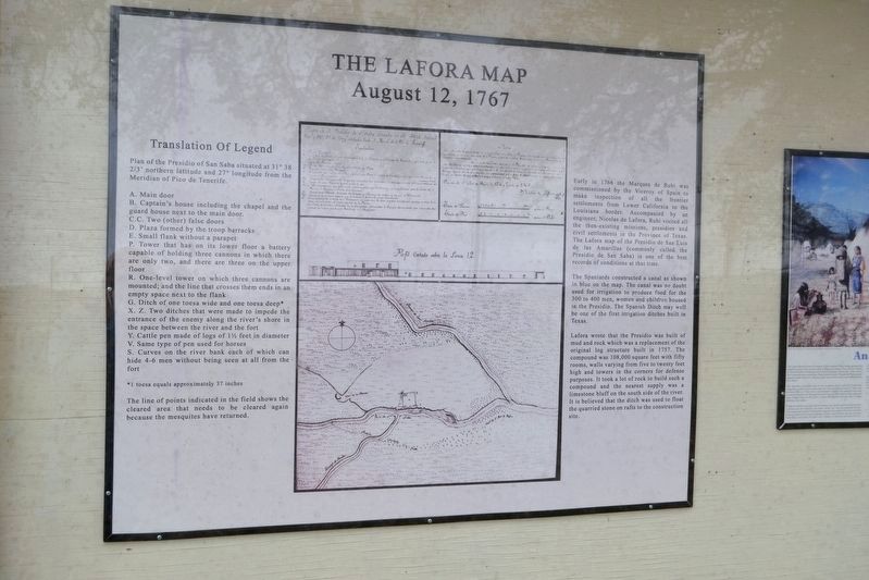
The Lafora Map
August 12, 1767
Early in 1766 the Marques de Rubi was commissioned by the Viceroy of Spain to make inspection of all the frontier settlements from Lower California to the Louisiana border. Accompanied by an engineer, Nicolas de Lafora, Rubi visited all the then-existing missions, presidios and civil settlements in the Province of Texas. The Lafora map of the Presidio de San Luis de las Amarillas (commonly called the Presidio de San Saba) is one of the best records of conditions at that time.
The Spaniards constructed a canal as shown in blue on the map. The canal was no doubt used for irrigation to produce food for the 300 to 400 men, women and children housed in the Presidio. The Spanish Ditch may well be one of the first irrigation ditches built in Texas.
Lafora wrote that the Presidio was built of mud and rock which was a replacement of the original log structure built in 1757. The compound was 108,000 square feet with fifty rooms, walls varying from five to twenty feet high and towers in the corners for defense purposes. It took a lot of rock to build such a compound and the nearest supply was a limestone bluff on the south side of the river. It is believed that the ditch was used to float the quarried stone on rafts to the construction site.
Translation of Legend
Plan of the Presidio of San Saba situated at 31° 38 2/3’ northern latitude and 27° longitude from the Meridian of Pico de Tenerife.
A. Main door
B. Captain’s house including the chapel and the guard house next to the main door
C. C. Two (other) false doors
D. Plaza formed by the troop barracks
E. Small flank without a parapet
P. Tower that has on its lower floor a battery capable of holding three cannons in which there are only two, and there are three on the upper floor
R. One-level tower on which three cannons are mounted; and the line that crosses them ends in an empty space next to the flank
G. Ditch of one toesa wide and one toesa deep*
X. Z. Two ditches that were made to impede the entrance of the enemy along the river’s shore in the space between the river and the fort
Y. Cattle pen made of logs of 1 ½ feet in diameter
V. Same type of pen used for horses
S. Curves on the river bank each of which can hide 4-6 men without being seen at all from the fort
* 1 toesa equals approximately 37 inches
The line of points indicated in the field shows the cleared area that needs to be cleared again because the mesquites have returned.
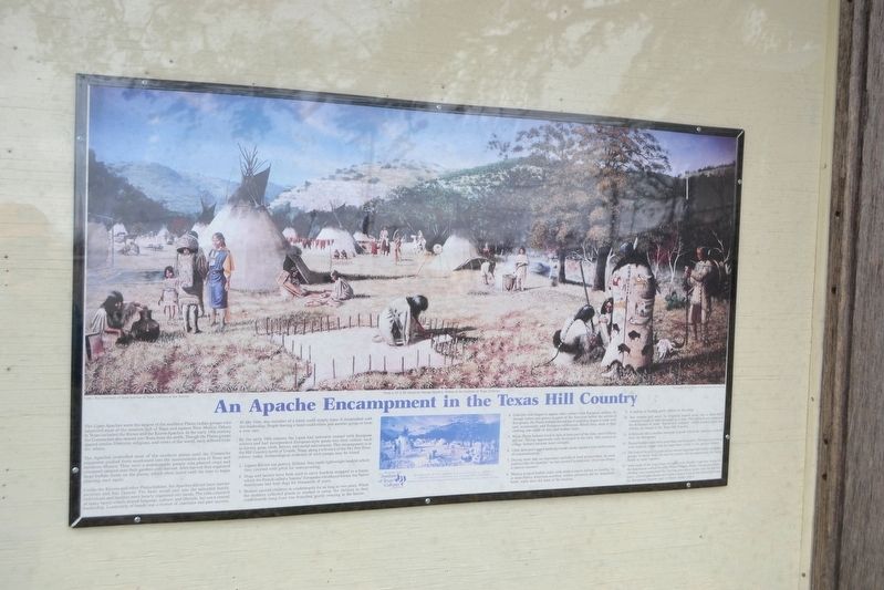
An Apache Encampment in the Texas Hill Country
The Lipan Apaches were the largest of the southern Plains Indian groups who inhabited most of the western half of Texas and eastern New Mexico. Others in Texas included the Kiowa and the Kiowa-Apaches. In the early 19th century the Comanches also moved into Texas from the north. Though the Plains groups shared similar lifestyles, religions, and views of the world, each differed from the others.
The Apaches controlled most of the southern plains until the Comanche expansion pushed them southward into the mountainous area of Texas and northern Mexico. They were a seminomadic people who planted crops and remained camped near their gardens until harvest. After harvest they organized large buffalo hunts on the plains which often lasted until the time to begin planting once again.
Unlike the Kiowas and other Plains Indians, the Apaches did not have warrior societies and Sun Dances. The basic social unit was the extended family. Individuals and families were loosely organized into bands. The tribe consisted of many bands which shared language, culture, and lifestyle, but not a central leadership. Leadership of bands was a matter of charisma and past success.
At any time, any member of a band could simply leave if dissatisfied with the leadership. People leaving a band could either join another group or form a new one.
By the early 19th century the Lipan had extensive contact with European settlers
and had incorporated European-style goods into their culture, such as horses, guns, cloth, knives, and metal adornments. This encampment is in the Hill County north of Uvalde, Texas, along a tributary of the Dry Frio River, where, today, archaeological evidence of such camps may be found.
- Lipans did not use pottery. Instead, they made lightweight baskets which they covered with pitch for waterproofing.
- Dogs and horses were both used to carry burdens strapped to a frame, which the French called a “travois.” Europeans introduced horses, but Native Americans had kept dogs for thousands of years.
- Women carried children in cradleboards for as long as two years. While the mothers collected plants or worked in camp, the children in their cradleboards hung from low branches, gently swaying in the breeze.
- Colorful cloth began to appear after contact with European settlers. Although cotton was grown in parts of the Americas before the arrival of the Europeans, the Plains Indians did not use it until they began to trade with and, occasionally, raid European settlements. Before then, most of their clothing was made of deer and buffalo hides.
- While Plains Indians lived in tipis at least part of the time, most Indians did not. The tipi apparently only developed in the early 18th century as village farmers became more nomadic.
- Clear skies and rugged landscape made smoke signals a very useful means of communication.
- Drying meat was an important method of food preservation. In most societies like the Apaches “no one starves if anyone eats.” Food was always a shared resource.
- Women scraped buffalo hides with stone scrapers hafted on handles. As in most Native American societies, women primarily did the household work, while men did most of the hunting.
- A raiding or hunting party returns to the camp.
- Two women boil water by dropping heated rocks into a water-filled container made of hide mounted on a rack. This method was employed for thousands of years. “Burnt-rock middens” which resulted from this activity are found in the Texas Hill Country.
- A flintlock rifle is another example of goods which the Apaches received from the Europeans.
- Painted buffalo hides were more than just decorative. The figures on them were icons or visual cues for important events in the group’s history.
- The fruit of the prickly pear cactus was an important fall food for all Indian groups. In South Texas the harvest season was an opportunity for many bands to come together.
- Vests made of the long bones of eagles were ritually important items for the Apaches as well as for other Plains Indians. Before European contact, clothing was ornamented by weaving porcupine quills into the leather. Later, colored glass beads and leather sashes with metal ornaments from the Europeans became part of Plains Indian attire.
Topics. This historical marker is listed in these topic lists: Colonial Era • Forts and Castles • Native Americans • Waterways & Vessels.
Location. 30° 54.987′ N, 99° 47.162′ W. Marker is in Menard, Texas, in Menard County. Marker is on Canal Street east of Ellis Street (U.S. 83), on the left when traveling east. Touch for map. Marker is in this post office area: Menard TX 76859, United States of America. Touch for directions.
Other nearby markers. At least 8 other markers are within walking distance of this marker. Sacred Heart Catholic Church (within shouting distance of this marker); Welcome to Menard, Texas / The Old Sacred Heart Catholic Church (within shouting distance of this marker); Founding of the Santa Cruz de San Saba Mission (within shouting distance of this marker); "The Ditch" (within shouting distance of this marker); Bank of Menard (about 400 feet away, measured in a direct line); Fort McKavett C.S.A. / Texas Civil War Frontier Defense (about 700 feet away); Menard County Memorial of Those Who Died (about 700 feet away); Great Western Trail (about 800 feet away). Touch for a list and map of all markers in Menard.
Credits. This page was last revised on March 31, 2018. It was originally submitted on March 31, 2018, by Duane Hall of Abilene, Texas. This page has been viewed 444 times since then and 17 times this year. Photos: 1, 2, 3. submitted on March 31, 2018, by Duane Hall of Abilene, Texas.


