Southwest Quadrant in Alexandria, Virginia — The American South (Mid-Atlantic)
Freedmen’s Cemetery
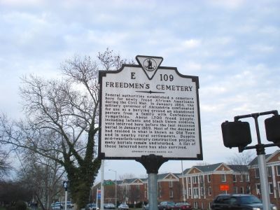
Photographed by Roger Dean Meyer, January 15, 2007
1. Freedman’s Cemetery Marker
Erected 2000 by Department of Historic Resources. (Marker Number E-109.)
Topics and series. This historical marker is listed in these topic lists: African Americans • Cemeteries & Burial Sites • Indigenous Peoples and Communities • War, US Civil. In addition, it is included in the Virginia Department of Historic Resources (DHR) series list. A significant historical month for this entry is January 1864.
Location. 38° 47.68′ N, 77° 2.962′ W. Marker is in Alexandria, Virginia. It is in the Southwest
this page online

Regionally, this marker is in the Washington Metropolitan Area and in Northern Virginia. It is also in the American South, specifically in the Upper South, in the Mid-Atlantic, and on the Eastern Seaboard. Globally, it is in the North Atlantic Region, North America, the Western Hemisphere, the Western World, and the Anglosphere. Historically, it finds itself in what was once the territory of the Mississippian Culture, one of the original Thirteen Colonies, one of the Confederate States of America, and the Antebellum South.
Other nearby markers. At least 8 other markers are within walking distance of this marker: Graves Under South Washington Street (here, next to this marker); Former USCT Burial Ground (a few steps from this marker); First Catholic Church in Virginia (within shouting distance of this marker);
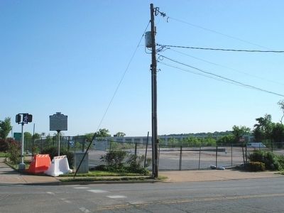
Photographed by Roger Dean Meyer, May 13, 2007
2. Wider view of the marker and the future park area.
Regarding Freedmen’s Cemetery. Until recently a gas station stood on the site, but it has been razed and archaeological work is now being conducted prior to establishment of the Freedmen’s Cemetery Memorial Park on this site.
This site also boasted a very early projectile point, and as such is important to American Indians.
Also see . . .
1. City of Alexandria Press Release. “Freedmen were enslaved African Americans who fled north during the Civil War in pursuit of freedom. Thousands of Freedmen sought refuge behind Union lines in towns like Alexandria. They lived in crowded barracks and shantytowns hastily constructed to accommodate their swelling numbers. For many, the Freedmen's Cemetery
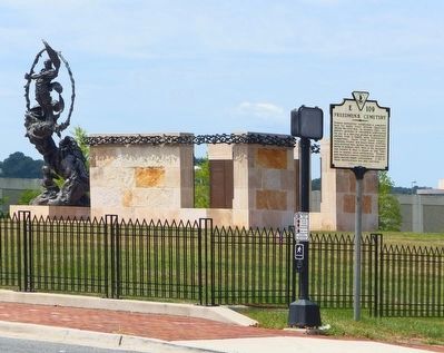
Photographed by Allen C. Browne, August 1, 2015
3. Updated Freedmen’s Cemetery Marker
2. Freedmen's Cemetery. “When the Civil War broke out, enslaved African Americans had a better sense of where the conflict would lead than did the combatants themselves. Many predicted, as the inevitable outcome of an armed conflict between North and South, the "Jubilee," the end of slavery, when families would be reunited in freedom.” (Submitted on April 3, 2011, by Richard E. Miller of Oxon Hill, Maryland.)
3. Alexandria [Va.] National Cemetery (Soldiers' Cemetery). At first, Black soldiers who died in Alexandria were buried at Freedmen's Cemetery, established for "contrabands" (liberated slaves) in February 1864. This appears to have been instituted at the insistence of the Superintendent of Contrabands, Black clergyman Reverend Albert Gladwin.
African-American soldiers recuperating at L'Ouverture General Hospital were outraged, and in December 1864 more than 440 of them signed a petition demanding that Soldiers' Cemetery be opened to Blacks: "To crush this rebellion, and establish
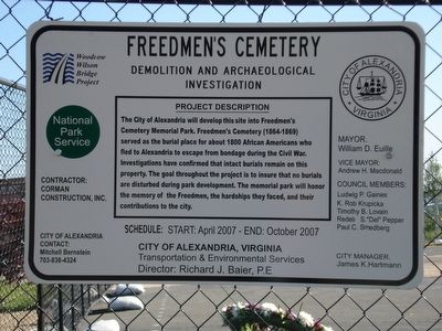
Photographed by Roger Dean Meyer, May 13, 2007
4. Site construction explanation signage.
The City of Alexandria will develop this site into Freedmen’s Cemetery Memorial Park. Freedmen’s Cemetery (1864–1869) served as the burial place for about 1800 African Americans who fled to Alexandria to escape from bondage during the Civil War. Investigations have confirmed that intact burials remain on this property. The goal throughout the project is to insure than no burials are disturbed during park development. The memorial park will honor the memory of the Freedmen, the hardships they faced, and their contributions to the city.
The petitioners prevailed. ... and Black soldiers joined their fallen White comrades at Soldiers' Cemetery. Those already buried at Freedmen's Cemetery were re-interred. ... (Submitted on April 3, 2011, by Richard E. Miller of Oxon Hill, Maryland.)
Additional keywords. "Contraband and Freedmen's Cemetery"; Clovis Point; Mario Chiodo, sculptor; "The Path of Thorns and Roses"
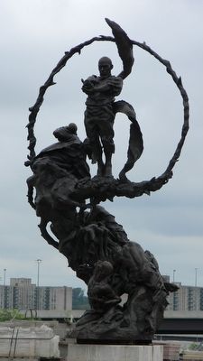
Photographed by Richard E. Miller, August 19, 2013
5. Sculpture recently installed at the "Place of Remembrance" in the restored
Credits. This page was last revised on January 27, 2023. It was originally submitted on July 17, 2007, by Roger Dean Meyer of Yankton, South Dakota. This page has been viewed 4,632 times since then and 47 times this year. Last updated on August 19, 2018, by Allen C. Browne of Silver Spring, Maryland. Photos: 1, 2. submitted on July 17, 2007, by Roger Dean Meyer of Yankton, South Dakota. 3. submitted on August 12, 2015, by Allen C. Browne of Silver Spring, Maryland. 4. submitted on July 17, 2007, by Roger Dean Meyer of Yankton, South Dakota. 5. submitted on August 24, 2013, by Richard E. Miller of Oxon Hill, Maryland. • Andrew Ruppenstein was the editor who published this page.
