Berwyn Heights in Prince George's County, Maryland — The American Northeast (Mid-Atlantic)
Town of Berwyn Heights
Anacostia Trails Heritage Area
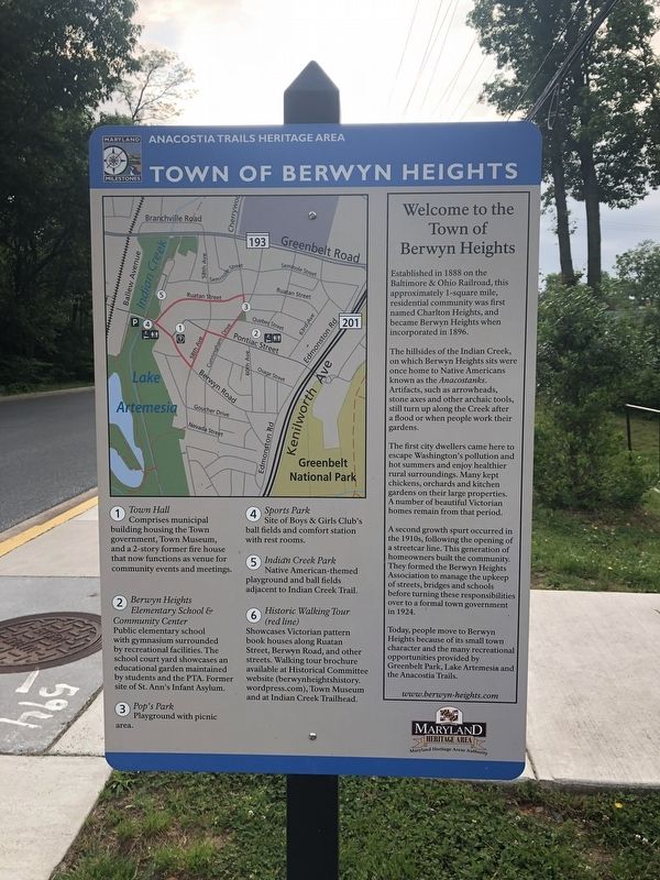
Welcome to the Town of Berwyn Heights
Established in 1888 on the Baltimore & Ohio Railroad, this approximately 1-square mile residential community was first named Charlton Heights, and became Berwyn Heights when incorporated in 1896.
The hillsides of the Indian Creek on which Berwyn Heights sits were once home to Native Americans known as the Anacostanks. Artifacts, such as arrowheads, stone axes and other archaic tools, sitll turn up along the Creek after a flood or when people work their gardens.
The first city dwellers came here to escape Washington's pollution and hot summers and enjoy healthier rural surroundings. Many kept chickens, orchards and kitchen gardens on their large properties. A number of beautiful Victorian homes remain from that period.
A second growth spurt occurred in the 1910s, following the opening of a streetcar line. This generation of homeowners built the community. They formed the Berwyn Heights Association to manage the upkeep of streets, bridges and schools before turning these responsibilities over to a formal town government in 1924.
Today, people move to Berwyn Heights because of its small town character and the many recreational opportunities provided by Greenbelt Park, Lake Artemesia and the Anacostia Trails.
① Town Hall
Comprises municipal building housing the Town government, Town Museum, and a 2-story former fire house that now functions as venue for community events and meetings.
② Berwyn Heights Elementary School & Community Center
Public elementary school with gymnasium surrounded by recreational facilities. The school court yard showcases an educational garden maintained by students and the PTA. Former site of the St. Ann's Infant Asylum.
③ Pop's Park
Playground with picnic area.
④ Sports Park
Site of Boys & Girls Club's ball fields and comfort station with rest rooms.
⑤ Indian Creek Park
Native American-themed playground and ball fields adjacent to Indian Creek Trail.
⑥ Historic Walking Tour (red line)
Showcases Victorian pattern book houses along Ruatan Street, Berwyn Road, and other streets. Walking tour brochure available at Historical Committee website (berwynehightshistory.wordpress.com), Town Museum and at Indian Creek Trailhead.
Erected by Maryland Heritage Area Authority.
Topics. This historical marker is listed in these topic lists: Anthropology & Archaeology • Native Americans • Parks & Recreational Areas • Settlements & Settlers. A significant historical year for this entry is 1888.
Location.
Other nearby markers. At least 8 other markers are within walking distance of this marker. Keleher Avenue (within shouting distance of this marker); a different marker also named Town of Berwyn Heights (about 400 feet away, measured in a direct line); Waugh Avenue (about 700 feet away); Veterans Memorial (about 800 feet away); Arrowhead (approx. 0.2 miles away); Welcome to the Luther Goldman Birding Trail (approx. ¼ mile away); Berwyn Heights Association (approx. ¼ mile away); Washington Spa Spring & Gretta Railroad (approx. ¼ mile away). Touch for a list and map of all markers in Berwyn Heights.
Credits. This page was last revised on February 20, 2023. It was originally submitted on May 18, 2019, by Devry Becker Jones of Washington, District of Columbia. This page has been viewed 155 times since then and 13 times this year. Photos: 1, 2, 3. submitted on May 18, 2019, by Devry Becker Jones of Washington, District of Columbia.


