Rockville in Montgomery County, Maryland — The American Northeast (Mid-Atlantic)
Dawson Farm - 1840-1979
Dawson Farm Park - Rockville’s History in Your Own Backyard
Dawson Family History
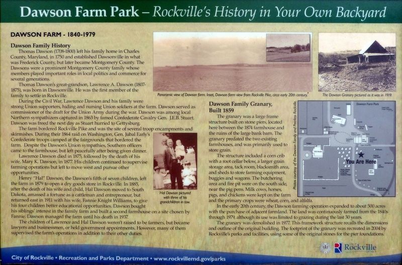
Thomas Dawson (1708-1800) left his family home in Charles County, Maryland, in 1750 and established Dawsonville in what was Frederick County, but later became Montgomery County. The Dawsons were a prominent Montgomery County family whose members played important roles in local politics and commerce for several generations.
Thomas Dawson's great-grandson, Lawrence A. Dawson (1807-1875), was born in Dawsonville. He was the first member of the family to settle in Rockville.
During the Civil War, Lawrence Dawson and his family were strong Union supporters, hiding and nursing Union soldiers at the farm. Dawson served as commissioner of the draft for the Union Army during the war. Dawson was among local Northern sympathizers captured in 1863 by famed Confederate Cavalry Gen. J.E.B. Stuart. Dawson was freed the next day as Stuart hurried to Gettysburg.
The farm bordered Rockville Pike and was the site of several troop encampments and skirmishes. During their 1864 raid on Washington, Gen. Jubal Early's Confederate troops camped at the fairgrounds that bordered the farm. Despite the Dawson's Union sympathies, Southern officers came to the farmhouse, but left peacefully after being given dinner.
Lawrence Dawson died in 1875, followed by the death of his wife, Mary K. Dawson, in 1877. His children continued to supervise farming operations but left to move west and pursue other opportunities.
Henry “Hal” Dawson, the Dawson's fifth of seven children, left the farm in 1879 to open a dry goods store in Rockville. In 1885, after the death of his wife and child, Hal Dawson moved to South Dakota, amassed a fortune as a cattleman and entrepreneur, but returned east in 1911 with his wife, Fannie Knight Williams, to give his four children better educational opportunities. Dawson bought his siblings' interest in the family farm and built a second farmhouse on a site chosen by Fannie. Dawson managed the farm until his death in 1937.
The children of Lawrence and Hal Dawson weren't raised to be farmers, but became lawyers and businessmen, or held government appointments. However, many of them supervised the farm’s operations in addition to their other duties.
Dawson Family Granary, Built 1859
The granary was a large frame structure built on stone piers, located here between the 1874 farmhouse and the ruins of the large bank barn. The granary predated the two existing farmhouses, and was primarily used to store grain.
The structure included a corn crib with a root cellar below, a larger grain storage area, tack room, blacksmith area, and sheds to store farming equipment, buggies and wagons. The butchering area and fire pit were on the south side, near the pig pens. Milk cows, horses, pigs, and chickens were kept on the farm and the primary crops were wheat, corn, and alfalfa.
In the early 20th century, the Dawson farming operation expanded to about 500 acres with the purchase of adjacent farmland. The land was continuously farmed from the 1840s through 1979, although its use was limited to grazing during the last 30 years.
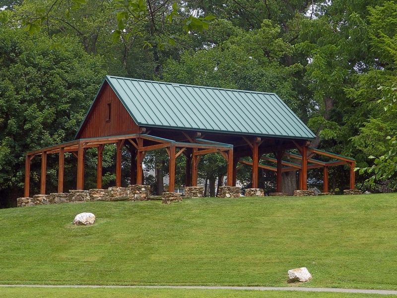
The granary was demolished in 1977. This framework structure recalls the dimensions and outline of the original building. The footprint of the granary was recreated in 2004 by Rockville's parks and facilities, using some of the original stones for the pier foundations.
Erected by City of Rockville, Department of Recreation and Parks.
Topics. This historical marker is listed in these topic lists: Agriculture • Colonial Era • Settlements & Settlers.
Location. 39° 4.471′ N, 77° 8.571′ W. Marker is in Rockville, Maryland, in Montgomery County. Marker can be reached from Ritchie Parkway. This marker is in Dawson Farm Park. Touch for map. Marker is at or near this postal address: 312 Ritchie Parkway, Rockville MD 20851, United States of America. Touch for directions.
Other nearby markers. At least 8 other markers are within walking distance of this marker. Rocky Glen Farm / Dawson Farmhouse: Built 1874 (within shouting distance of this marker); Rocky Glen Farm / Dawson Farm: 1840-1980 (within shouting distance of this marker); Rocky Glen Farm / Dawson Farmhouse: Built 1912 (about 400 feet away, measured in a direct line); John C. Brown Memorial Bridge (approx. 0.4 miles away); Saint Mary's Church (approx. half a mile away); Saint Mary's Catholic Church (approx. half a mile away); Rockville Station (approx. 0.6 miles away); Montgomery County Jail (approx. 0.7 miles away). Touch for a list and map of all markers in Rockville.
Credits. This page was last revised on July 8, 2022. It was originally submitted on June 20, 2019, by Allen C. Browne of Silver Spring, Maryland. This page has been viewed 770 times since then and 81 times this year. Last updated on July 6, 2022, by Carl Gordon Moore Jr. of North East, Maryland. Photos: 1, 2. submitted on June 20, 2019, by Allen C. Browne of Silver Spring, Maryland. 3, 4. submitted on June 26, 2019, by Allen C. Browne of Silver Spring, Maryland. • Devry Becker Jones was the editor who published this page.


