St. Mary's City in St. Mary's County, Maryland — The American Northeast (Mid-Atlantic)
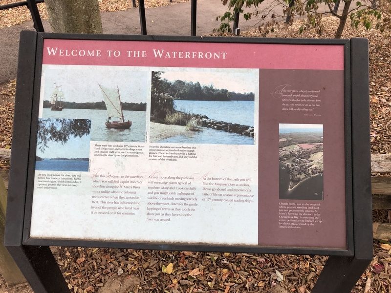
Welcome to the Waterfront
Take this path down to the waterfront where you will find a quiet stretch of shoreline along the St. Mary's River shoreline along the St. Mary's River—not unlike what the colonists encountered when they arrived in 1634. This river has influenced the lives of the people who lived near it or traveled on it for centuries.
As you move along the path you will see native plants typical of southern Maryland. Look carefully and you might catch a glimpse of wildlife or see birds moving serenely above the water. Listen for the gentle lapping of waves as they touch the shore just as they have since the river was created.
At the bottom of the path you will find the Maryland Dove at anchor. Please go aboard and experience a taste of life on a vessel representative of 17th-century coastal trading ships.
"This river [the St. Mary's] runs forward from south to north about twenty miles before it is absorbed by the salt water from the sea. In its mouth one can see two bays, able to hold 300 ships of huge size."
Father Andrew White, 1634
[Captions:]
As you look across the river, you will notice few modern intrusions. Scenic easement rights, which control development, protect the view for everyone's enjoyment.
There were few docks in 17th-century Maryland. Ships were anchored in deep water and smaller craft were used to carry goods and people directly to the plantations.
Near the shoreline are stone barriers that create narrow wetlands of native marsh grasses. These wetlands provide a habitat for fish and invertebrates and they inhibit erosion of the riverbank.
Church Point, just to the north of where you are standing (red dot), just out prominently into the St. Mary's River. In the distance is the Chesapeake Bay. At one time the entire peninsula was forested except for those areas cleared by the American Indians.
Erected by Historic St. Mary's City.
Topics. This historical marker is listed in these topic lists: Colonial Era • Environment • Settlements & Settlers • Waterways & Vessels. A significant historical year for this entry is 1634.
Location. 38° 11.17′ N, 76° 26.07′ W. Marker is in St. Mary's City, Maryland, in St. Mary's County. Marker can be reached from Old State House Road, 0.4 miles north of Point Lookout Road (Maryland Route 5), on the left when traveling north. Touch for map. Marker is at or near this postal address: 47414 Old State House Road, Saint Marys City MD 20686, United States of America. Touch for directions.
Other nearby markers. At least 8 other markers are within walking distance of this marker. "…for the good and happy Government" (a few steps from this marker); Watery Highways
Credits. This page was last revised on March 20, 2024. It was originally submitted on October 5, 2019, by Devry Becker Jones of Washington, District of Columbia. This page has been viewed 163 times since then and 8 times this year. Photos: 1, 2. submitted on October 5, 2019, by Devry Becker Jones of Washington, District of Columbia.

