Saint John in Saint John County, New Brunswick — The Atlantic Provinces (North America)
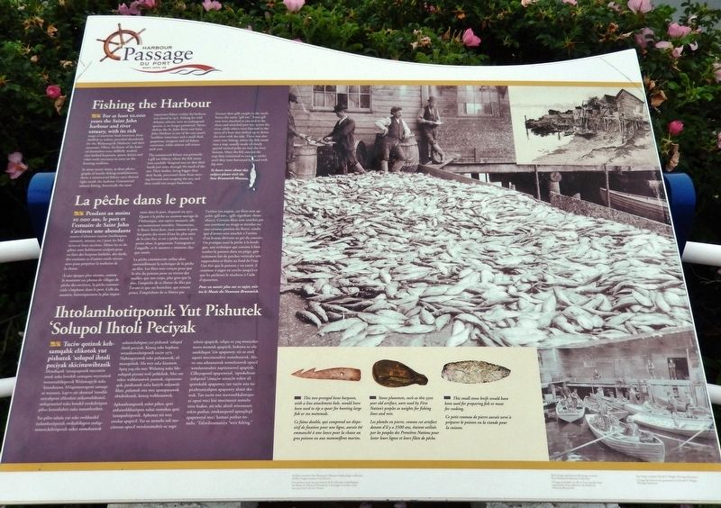
Fishing the Harbour
La pêche dans le port
— Harbour Passage Trail —
For at least 10,000 years the Saint John harbour and river estuary, with its rich range of maritime food resources, from shellfish to walrus, provided abundantly for the Wolastoqiyik (Maliseet) and their ancestors. Often, the bones of the hunted themselves were skillfully worked into barbed harpoons, spears, knives and other tools necessary to carry on the hunting tradition.
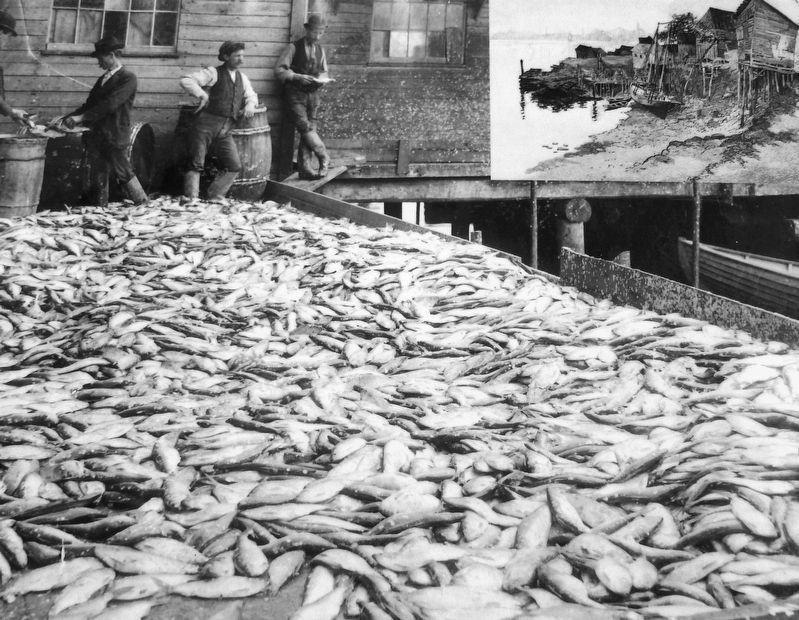
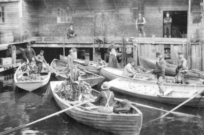
In more recent times, as these photographs of nearby fishing establishments show, a commercial fishery once thrived right inside the harbour. Commercial salmon fishing, historically the most important fishery within the harbour, was closed in 1971. Fishing for wild Atlantic salmon, now an endangered species, is no longer permitted. Nevertheless, the St. John River and Saint John Harbour is one of the east coast's healthier waterways and a small shad, gaspereau, sturgeon and eel fishery continues, while salmon still return each year.
The commercial fishery was primarily a gill net fishery, where the fish swam into carefully designed nets so that their heads just went through the mesh of the net. Their bodies, being bigger than their heads, prevented them from moving forward and escaping the net, and they could not escape backwards, because their gills caught in the mesh, hence the name "gill net." Some gill nets were attached at one end to the shore and stretched part way across the river, while others were fastened to the stern of a boat that drifted up or down the river with the tide. There was also some weir fishing, where the fish swam into a trap, usually made of closely spaced vertical poles set into the river bottom. Once the fish entered the trap they continued to swim in circles until they were harvested by hand with dip nets.
To learn more about this subject please visit the New Brunswick Museum.
Pendant au moins 10 000 ans, le port et l'estuaire de Saint John s'avèrent une abondante source d'aliments marins (mollusques, crustacés, morses, etc.) pour les Malécites et leurs ancêtres. Même les os du gibier sont habilement sculptés pour en faire des harpons barbelés, des dards, des couteaux et d'autres outils nécessaires pour perpétrer la tradition de la chasse.
À une époque plus récente, comme le montrent ces photos de villages de pêche des environs, la pêche commerciale s'implante dans le port. Celle du saumon, historiquement la plus importante dans le port, disparaît en 1971. Quant à la pêche au saumon sauvage de l'Atlantique, une espèce menacée, elle est maintenant interdite. Néanmoins, le fleuve Saint-Jean, tout comme le port, fait partie des cours d'eau les plus sains de la côte Est, et on y pêche encore la petite alose, le gaspareau, l'esturgeon et l'anguille, et le saumon y retourne chaque année.
La pêche commerciale utilise alors essentiellement la technique de la pêche au filet. Les filets sont conçus pour que la tête du poisson passe au travers des mailles, que son corps, plus gros que la tête, l'empêche de se libérer du filet par l'avant et que ses branchies, qui restent prises, l'empêchent de se libérer par l'arrière (en anglais, ces filets sont appelés «gill net», «gill» signifiant «branchies»). Certains filets sont attachés par une extrémité au rivage et étendus sur une certaine portion du fleuve, tandis que d'autres sont attachés à l'arrière d'un bateau dérivant au gré du courant. On pratique aussi la pêche à la bordigue, une technique qui consiste à faire tomber le poisson dans un piège, généralement fait de perches verticales très rapprochées et fixées au fond de l'eau. Une fois que le poisson y est entré, il continue à nager en cercles jusqu'à ce que les pêcheurs le récoltent à l'aide d'épuisettes.
Pour en savoir plus sur ce sujet, visitez le Musée du Nouveau-Brunswick.
Topics. This historical marker is listed in these topic lists: Agriculture
Courtesy New Brunswick Museum Archaeology Collection, images courtesy Leo Doucet
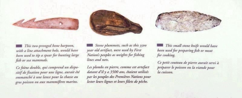
3. Marker detail: Fishing implements / Outils de pêche
This two-pronged bone harpoon, with a line attachment hole, would have been used to tip a spear for hunting large fish or sea mammals.
Ce foène double, qui comprend un dispositif de fixation pour une ligne, aurait été emmanché à une lance pour la chasse au gros poisson ou aux mammifères marins.
(center)
Stone plummets, such as this 3500 year old artifact, were used by First Nation's peoples as weights for fishing lines and nets.
Les plombs en pierre, comme cet artefact datant d'il y a 3500 ans, étaient utilisés par les peuples des Premières Nations pour lester leurs lignes et leurs filets de pêche.
(right)
This small stone knife would have been used for preparing fish or meat for cooking.
Ce petit couteau de pierre aurait servi à préparer le poisson ou la viande pour la cuisson.
Location. 45° 16.197′ N, 66° 4.623′ W. Marker is in Saint John, New Brunswick, in Saint John County. Marker can be reached from the intersection of Chesley Drive (New Brunswick Route 100) and Bentley Street, on the right when traveling north. Marker is located along the Harbour Passage Trail, about 2.5 km north of the Bentley Street trailhead. Touch for map. Marker is in this post office area: Saint John NB E2K 1B2, Canada. Touch for directions.
Other nearby markers. At least 8 other markers are within walking distance of this marker. Navy Island (Ouigoudy Island) (here, next to this marker); The Saint John Harbour Bridge | Le pont du port de Saint John (about 180 meters away, measured in a direct line); The Tides of Fundy (about 210 meters away); Ancient Life (about 240 meters away); Fossil Hunters (about 240 meters away); The Shards of Time (approx. 0.4 kilometers away); Fort La Tour (approx. half a kilometer away); a different marker also named Fort La Tour (approx. half a kilometer away). Touch for a list and map of all markers in Saint John.
Credits. This page was last revised on November 3, 2022. It was originally submitted on April 7, 2020, by Cosmos Mariner of Cape Canaveral, Florida. This page has been viewed 111 times since then and 5 times this year. Photos: 1, 2, 3, 4, 5. submitted on April 8, 2020, by Cosmos Mariner of Cape Canaveral, Florida.
