Near Fredonia in Mohave County, Arizona — The American Mountains (Southwest)
Pipe Spring National Monument
Photographed by Cosmos Mariner, June 10, 2016
1. Pipe Spring National Monument Marker
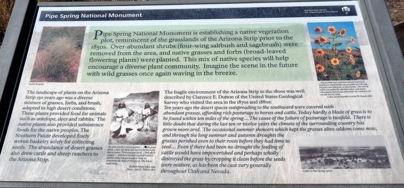
The landscape of plants on the Arizona Strip 150 years ago was a diverse mixture of grasses, forbs, and brush, adapted to high desert conditions. These plants provided food for animals such as antelope, deer and rabbits. The native plants also provided subsistence foods for the native peoples. The Southern Paiute developed finely woven basketry solely for collecting seeds. The abundance of desert grasses also drew cattle and sheep ranchers to the Arizona Strip.
The fragile environment of the Arizona Strip in the 1800s was well described by Clarence E. Dutton of the United States Geological Survey who visited the area in the 1870s and 1880s:
Ten years ago the desert spaces outspreading to the southward were covered with abundant grasses, affording rich pasturage to horses and cattle. Today hardly a blade of grass is to be found within ten miles of the spring… The cause of the failure of pasturage is twofold. There is little doubt that during the last ten or twelve years the climate of the surrounding country has grown more arid. The occasional summer showers which kept the grasses alive seldom come now, and through the long summer and autumn droughts the grasses perished even to their roots before they had time to seed… Even if there had been no drought the feeding of cattle would have impoverished and perhaps wholly destroyed the grass by cropping it clean before the seeds were mature, as has been the case very generally throughout Utah and Nevada.
(photo captions)
•
this page online
• (upper right) …The foothills that yielded hundreds of acres of sunflowers which produced quantities of rich seed, the grass also that grew so luxuriantly… the seed of which was gathered with little labor, and many other plants that produced food for the natives is all eat out [sic] by stock.
—Letter, Jacob Hamblin to John W. Powell, 1880
• (lower right) Cattle at Pipe Spring Ranch
Erected by National Park Service, U.S. Department of the Interior.
Topics. This historical marker and monument is listed in these topic lists: Environment • Horticulture & Forestry • Indigenous Peoples and Communities • Settlements & Settlers.
Location. 36° 51.761′ N, 112° 44.274′ W. Marker is near Fredonia, Arizona, in Mohave County. It can be reached from North Pipe Spring Road 0.3 miles north of Arizona Route 389, on the left when traveling north. Marker is located along the park grounds trail in Pipe Spring National Monument. Touch for map. Marker is at or near this postal address: 406 North Pipe Spring Road, Fredonia AZ 86022, United States of America.
Photographed by John K Hillers, 1872
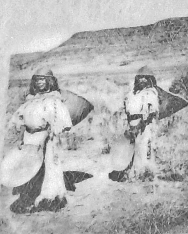
2. Marker detail: Kaibab Paiute
My grandmother used to gather… a little green plant, a little old bush, and she'd whip the seeds into a basket. That was good food… First she'd roast it… And then she used to grind it and it used to make real good soup or stew or sometimes she made it into gravy. Oh, it was really tasty.—Kaibab Paiute elder, 1995

Regionally, this marker and monument is in the American Southwest and on the Colorado Plateau. Globally, it is in North America, the Western Hemisphere, the Western World, and the Anglosphere. Historically, it finds itself in what was once New Spain and also Mexico’s Alta California.
Other nearby markers. At least 8 other markers are within walking distance of this marker: At Home in the Desert (about 300 feet away, measured in a direct line); A Good Drink of Water (about 500 feet away); Pipe Springs National Monument (about 500 feet away); A Thousand Years of Gardens (about 500 feet away); A Tithing Ranch (about 500 feet away); Moamop' (about 600 feet away); 995 Miles of Wire (about 700 feet away); Skoomp (about 700 feet away). Touch for a list and map of all markers in Fredonia.
Related markers. Click here for a list of markers that are related to this marker. Pipe Spring National Monument
Also see . . . Panorama of the Grassland Exhibit. (A National Park Service link for this marker.) (Submitted on May 4, 2020, by Cosmos Mariner of Cape Canaveral, Florida.)

Photographed by Cosmos Mariner, June 10, 2016
3. Pipe Spring National Monument Marker
Photographed by Cosmos Mariner, June 10, 2016
4. Pipe Spring National Monument Marker
Credits. This page was last revised on May 7, 2020. It was originally submitted on May 4, 2020, by Cosmos Mariner of Cape Canaveral, Florida. This page has been viewed 326 times since then and 21 times this year. Photos: 1, 2, 3, 4. submitted on May 4, 2020, by Cosmos Mariner of Cape Canaveral, Florida.
