Strasburg in Shenandoah County, Virginia — The American South (Mid-Atlantic)
A Natural Bombproof
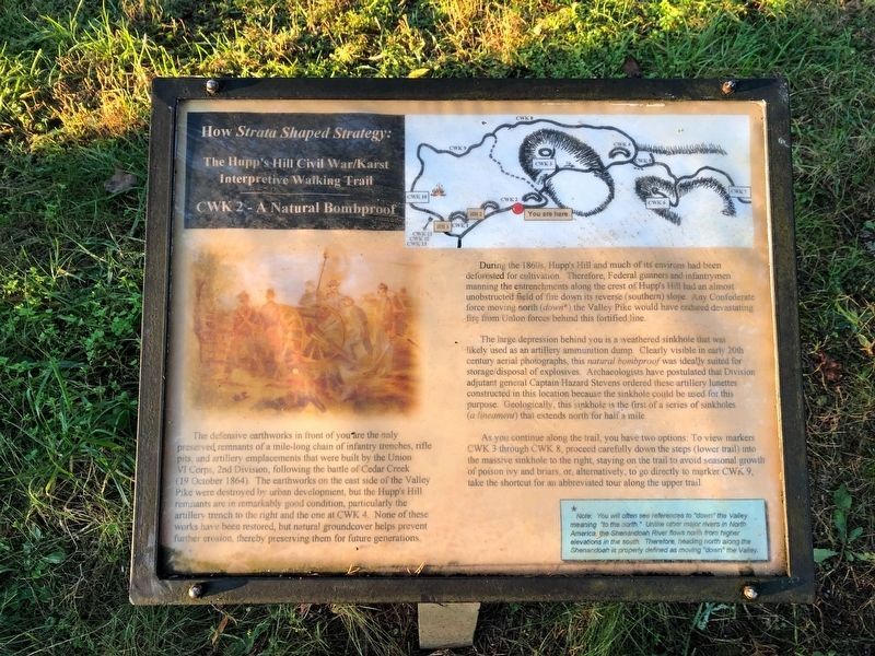
How Strata Shaped Strategy: The Hupp's Hill Civil War/Karst Interpretive Walking Trail
The defensive earthworks in front of you are the only preserved remnants of a mile-long chain of infantry trenches, rifle pits, and artillery emplacements that were built by the Union VI Corps, 2nd Division, following the battle of Cedar Creek (19 October 1864). The earthworks on the east side of the Valley Pike were destroyed by urban development, but the Hupp's Hill remnants are in remarkably good condition, particularly the artillery trench to the right and the one at CWK 4. None of these works have been restored, but natural groundcover helps prevent further erosion, thereby preserving them for future generations.
During the 1860's, Hupp's Hill and much of its environs had been deforested for cultivation. Therefore, Federal gunners and infantrymen manning the entrenchments along the crest of Hupp's Hill had an almost unobstructed field of fire down its reverse (southern) slope. Any Confederate force moving north (down*) the Valley Pike would have endured devastating fire from Union forces behind this fortified line.
The large depression behind you is a weathered sinkhole that was likely used as an artillery ammunition dump. Clearly visible in early 20th century aerial photographs, this natural bombproof was ideally suited for storage/disposal of explosives. Archaeologists have postulated that Division adjutant general Captain Hazard Stevens ordered these artillery lunettes constructed in this location because the sinkhole could be used for this purpose. Geologically, this sinkhole is the first of a series of sinkholes (a lineament) that extends north for half a mile.
As you continue along the trail, you have two options: To view markers CWK 3 through 8, proceed carefully down the steps (lower trail) into the massive sinkhole to the right, staying on the trail to avoid seasonal growth of poison ivy and briars, or, alternatively go directly to marker CWK 9, take the shortcut for an abbreviated tour along the upper trail.
*Note: You will often see references to "down" the Valley meaning "to the north." Unlike other major rivers in North America, the Shenandoah River flows north from higher elevations in the south. Therefore, heading north along the Shenandoah is properly defined as moving "down" the Valley.
Erected by Cedar Creek Battlefield Foundation. (Marker Number CWK 2.)
Topics and series. This historical marker is listed in these topic lists: Natural Features • War, US Civil • Waterways & Vessels.
Location. 39° 0.034′ N, 78° 20.993′ W. Marker is in Strasburg, Virginia, in Shenandoah County. Marker can be reached from Old Valley Pike (U.S. 11) 0.1 miles west of Signal Knob Drive, on the right when traveling west. Touch for map. Marker is at or near this postal address: 33229 Old Valley Pike, Strasburg VA 22657, United States of America. Touch for directions.
Other nearby markers. At least 8 other markers are within walking distance of this marker. Field Fortifications (within shouting distance of this marker); The Shenandoah Valley / Battle of Cedar Creek, October 19, 1864 (within shouting distance of this marker); Trail Head (within shouting distance of this marker); Hupp’s Hill (within shouting distance of this marker); Strasburg (within shouting distance of this marker); Hupp Cave (within shouting distance of this marker); Signal Knob (within shouting distance of this marker); Keyhole Cave (about 300 feet away, measured in a direct line). Touch for a list and map of all markers in Strasburg.
Credits. This page was last revised on November 7, 2020. It was originally submitted on November 1, 2020, by Devry Becker Jones of Washington, District of Columbia. This page has been viewed 128 times since then and 12 times this year. Photos: 1, 2. submitted on November 1, 2020, by Devry Becker Jones of Washington, District of Columbia.

