Winchester, Virginia — The American South (Mid-Atlantic)
Kernstown Battlefield
A Unique Civil War Site
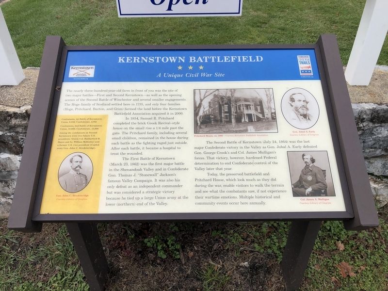
The nearly three-hundred-year-old farm in front of you was the site of two major battlefields—First and Second Kernstown—as well as the opening scenes of the Second Battle of Winchester and several smaller engagements. The Hoge family of Scotland settled here in 1735, and only four families (Hoge, Pritchard, Burton, and Grim) farmed the land before the Kernstown Battlefield Association acquired it in 2000.
In 1854, Samuel R. Pritchard completed the brick Greek Revival-style house on the small rise a 1/4 mile past the gate. The Pritchard family, including several small children, remained in the house during each battle as the fighting raged just outside. After each battle, it became a hospital to treat the wounded.
The First Battle of Kernstown (March 23, 1862) was the first major battle in the Shenandoah Valley and in Confederate Gen. Thomas J. "Stonewall" Jackson's famous Valley Campaign. It was also his only defeat as an independent commander but was considered a strategic victory because he tied up a large Union army at the lower (northern) end of the Valley.
The Second Battle of Kernstown (July 24, 1864) was the last major Confederate victory in the Valley as Gen. Jubal A. Early defeated Gen. George Crook's and Col. James Mulligan's forces. That victory, however, hardened Federal determination to end Confederate control of the Valley later that year.
Today, the preserved battlefield and Pritchard House, which look much as they did during the war, enable visitors to walk the terrain and see what the combatants saw, if not experience their wartime emotions. Multiple historical and community events occur here annually.
[Sidebar:]
Combatants, 1st Battle of Kernstown:
Union, 6,532; Confederate 2,752
Combatants, 2nd Battle of Kernstown:
Union, 10,000 Confederate, 13,000
Among the combatants at Second Kernstown were two future U.S. presidents (Union Col. Rutherford B. Hayes and Lt. William McKinley) and a former U.S. vice president (Confederate Gen. John C. Breckinridge).
Erected by Kernstown Battlefield Association; Virginia Civil War Trails.
Topics and series. This historical marker is listed in these topic lists: Architecture • Colonial Era • Settlements & Settlers • War, US Civil. In addition, it is included in the Former U.S. Presidents: #19 Rutherford B. Hayes, the Former U.S. Presidents: #25 William McKinley, and the Virginia Civil War Trails series lists. A significant historical year for this entry is 1735.
Location. 39° 8.641′
Other nearby markers. At least 8 other markers are within walking distance of this marker. The Pritchard House (approx. ¼ mile away); Second Battle of Kernstown (approx. ¼ mile away); a different marker also named The Second Battle of Kernstown (approx. ¼ mile away); The First Battle of Kernstown (approx. ¼ mile away); Second Battle of Winchester (approx. 0.3 miles away); a different marker also named The Second Battle of Kernstown (approx. 0.3 miles away); a different marker also named The First Battle of Kernstown (approx. 0.3 miles away); Battle of Kernstown (approx. 0.3 miles away). Touch for a list and map of all markers in Winchester.
Credits. This page was last revised on November 2, 2020. It was originally submitted on November 2, 2020, by Devry Becker Jones of Washington, District of Columbia. This page has been viewed 278 times since then and 30 times this year. Last updated on November 2, 2020, by Bradley Owen of Morgantown, West Virginia. Photos: 1, 2. submitted on November 2, 2020, by Devry Becker Jones of Washington, District of Columbia.

