Near Chester in Chesterfield County, Virginia — The American South (Mid-Atlantic)
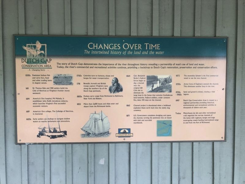
Changes Over Time
The intertwined history of the land and the water
ó Dutch Gap Conservation Area: A Changing Story ó
The story of Dutch Gap demonstrates the importance of the river throughout history revealing a partnership of manís use of land and water. Today, the riverís commercial and recreational activities continue, providing a backdrop to Dutch Gapís restoration, preservation and conservation efforts.
1500s
Powhatan Indians fish and carry furs, food and other trade items in dugout canoes.
1611
Sir Thomas Dale and 300 settlers build the Citie of Henricus as Virginiaís frontier moves westward.
1614
Americaís first English hospital, Mt Malady, is established. John Rolfe introduces tobacco, which launches Virginiaís first successful economic venture.
1619
Americaís first college, The College of Henricus, is chartered.
1620s
Early settlers use shallops to navigate shallow waters to nearby settlements and plantations.
1700s
Colonists turn to batteaux, sloops and barges for water transportation.
1781
Benedict Arnold and British troops capture Virginiaís navy along the southern tip of the Dutch Gap peninsula.
1800s
Packets carry cargo from Richmond to Baltimore, New York and Boston.
1855
More than 2,600 boats and ships enter and depart from the Richmond docks.
1864
Gen. Benjamin Butlerís Federal forces begin to dig a channel near the original 1611 Citie site to eliminate the large loop in the James that contains Confederate land batteries. Federal soldiers, under constant fire, labor 144 days on the channel.
1865
Channel project is abandoned when a bulkhead explosion blasts earth back into the newly dug causeway.
1871
U.S. Government completes dredging and opens the channel, turning the peninsula into an island with tidal and non-tidal marshlands.
1872
The steamship Sylvester is the first commercial vessel to use the new channel.
1930s
Army Corp of Engineers extends the channel. This eliminates another loop in the river.
1930s-1960s
Sand and gravel is mined, creating a tidal lagoon.
1997
Dutch Gap Conservation Area is created as a regional partnership providing historical, environmental and recreational activities to thousands of visitors each year.
Today
Motorboats, jet skis and other recreational craft negotiate the narrow channels of the James with tugboats, barges and large ocean-going vessels hauling international cargo to and from the Port of Richmond.
Erected by Chesapeake Bay Gateways

Photographed By Devry Becker Jones (CC0), May 8, 2020
2. Changes Over Time Marker
An additional plaque is on the visitor center building.
Topics. This historical marker is listed in these topic lists: Colonial Era • Parks & Recreational Areas • Settlements & Settlers • Waterways & Vessels. A significant historical year for this entry is 1611.
Location. 37° 22.572′ N, 77° 21.576′ W. Marker is near Chester, Virginia, in Chesterfield County. Marker can be reached from Henricus Park Road, 1.3 miles east of Coxendale Road. The marker is located in Henricus Historical Park 300 yards north of the parking lot. Touch for map. Marker is at or near this postal address: 251 Henricus Park Road, Chester VA 23836, United States of America. Touch for directions.
Other nearby markers. At least 8 other markers are within walking distance of this marker. John Smith Explores the Chesapeake (a few steps from this marker); Henricus Historical Park (within shouting distance of this marker); The Church of Henricopolis (within shouting distance of this marker); Henricopolis (within shouting distance of this marker); The Lightkeeperís House (within shouting distance of this marker); Dutch Gap Canal (within shouting distance of this marker); The Bermuda Hundred Campaign (within shouting distance of this marker); USCTs At Dutch Gap (within shouting distance of this marker). Touch for a list and map of all markers in Chester.
Also see . . .
1. Henricus Historical Park. (Submitted on February 15, 2009, by Bernard Fisher of Richmond, Virginia.)
2. Chesapeake Bay Gateways Network. (Submitted on February 15, 2009, by Bernard Fisher of Richmond, Virginia.)
3. Dutch Gap Conservation Area. (Submitted on February 15, 2009, by Bernard Fisher of Richmond, Virginia.)
Credits. This page was last revised on July 22, 2020. It was originally submitted on February 15, 2009, by Bernard Fisher of Richmond, Virginia. This page has been viewed 1,041 times since then and 18 times this year. Photos: 1. submitted on February 15, 2009, by Bernard Fisher of Richmond, Virginia. 2. submitted on May 9, 2020, by Devry Becker Jones of Washington, District of Columbia. • Craig Swain was the editor who published this page.
