Hills Park in Atlanta in Fulton County, Georgia — The American South (South Atlantic)
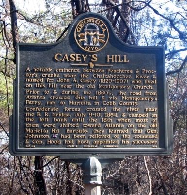
Casey's Hill
Prior to & during the 1860s, the road from Atlanta crossed this hill & via Montgomery’s Ferry, ran to Marietta in Cobb County.
Confederate forces crossed the river near the R.R. bridge, July 9-10, 1864, & camped on the left bank until the 18th when most of them shifted toward Atlanta on the old Marietta Rd. Enroute, they learned that Gen. Johnson [CS] had been relieved of the command & Gen. Hood had been appointed his successor.
Erected 1956 by Georgia Historical Commission. (Marker Number 060-86.)
Topics and series. This historical marker is listed in these topic lists: Roads & Vehicles • War, US Civil. In addition, it is included in the Georgia Historical Society series list. A significant historical year for this entry is 1864.
Location. 33° 48.602′ N, 84° 26.781′ W. Marker is in Atlanta, Georgia, in Fulton County. It is in Hills Park. Marker is on Old Marietta Road NW, 0.2 miles north of Marietta Road NW, on the right when traveling south. Casey's Hill and the marker are at the very rear (west) of Crest Lawn Memorial Park (2000 Marietta Boulevard). Old Marietta Road and Maid Lane are closed off and accessible only through Crest Lawn. Touch for map. Marker is in this post office area: Atlanta GA 30318, United States of America. Touch for directions.
Other nearby markers. At least 8 other markers are within 2 miles of this marker, measured as the crow flies. Atlanta's Outer Line (about 500 feet away, measured in a direct line); Montgomery Cemetery (approx. 0.7 miles away); French's Line (approx. 0.9 miles away); Johnston’s Army Crossed the River (approx. 1.1 miles away); Disputed Passage (approx. 1.1 miles away); Moore's Mill (approx. 1.2 miles away); Battle at Moore’s Mill (approx. 1.2 miles away); Standing Peach Tree (approx. 1.3 miles away). Touch for a list and map of all markers in Atlanta.
Credits. This page was last revised on February 8, 2023. It was originally submitted on February 28, 2009, by David Seibert of Sandy Springs, Georgia. This page has been viewed 1,517 times since then and 50 times this year. Photo 1. submitted on February 28, 2009, by David Seibert of Sandy Springs, Georgia. • Craig Swain was the editor who published this page.
Editor’s want-list for this marker. A wide shot of the marker and its surroundings. • Can you help?
