Near Williamsburg in James City County, Virginia — The American South (Mid-Atlantic)
The Greate Road – An Early Highway pre-1607-1700s
Inscription.
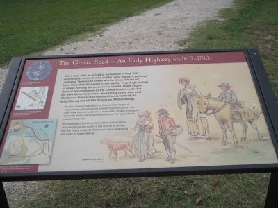
A few days after he arrived at Jamestown in May 1607, George Percy wrote that he and his party “espied a pathway” and were “desirous to knowe whither it would bring us.” Most likely they discovered a trail used by Paspahegh Indians in whose territory Jamestown was located. To the English, the trail became known as the Grate Road, a route that led from James Fort, across the isthmus to the west past Glasshouse Point on the mainland, and eventually to Green Spring and Middle Plantation (Williamsburg).
As New Towne developed, the Greate Road began at the junction of Backstreet and the highway by the river. Over time the trail widened to more than 30 feet as wagons drawn by horses and oxen packed down the top soil and created deep ruts.
Archaeologists found sections of the Greate Road, including a portion north of the church. Stretches are still visible today at Glasshouse Point and along the route to Green Spring.
Erected by Colonial National Historic Park.
Topics. This historical marker is listed in these topic lists: Colonial Era • Roads & Vehicles. A significant historical month for this entry is May 1607.
Location. 37° 12.502′ N, 76° 46.673′ W. Marker is near Williamsburg, Virginia, in James City County. Marker can be reached from Colonial Parkway, on the right when traveling west. Marker is in the "New Towne" section of the Historic Jamestown unit of Colonial National Historic Park. Touch for map. Marker is in this post office area: Williamsburg VA 23185, United States of America. Touch for directions.
Other nearby markers. At least 8 other markers are within walking distance of this marker. Backstreet – Jamestown’s Main Street 1620-1699 (within shouting distance of this marker); The Tombs of James and Sarah Blair (within shouting distance of this marker); The Tombstones (within shouting distance of this marker); The First General Assembly of Virginia (within shouting distance of this marker); East Bulwark (within shouting distance of this marker); Fort Extension, Blockhouse (within shouting distance of this marker); Barracks (within shouting distance of this marker); Jamestown (within shouting distance of this marker). Touch for a list and map of all markers in Williamsburg.
More about this marker. The right of the marker contains a drawing of “Colonial Virginia travelers, by Sidney King ca. 1957.” The bottom left of the marker features a map of the Route of Greate Road, with the caption “Route of the Greate Road from New Towne, across the isthmus to Glasshouse Point and beyond.” Above this is a “Map showing archaeological evidence of the Greate Road north of the Jamestown Church site.” The upper left has a photograph
of a “Decorative metal bass from a horse’s bridle.”
Also see . . .
1. The Greate Road - An Early Highway pre-1607 - 1700s. Colonial National Historic Park from National Park Service website. (Submitted on March 16, 2009, by Bill Coughlin of Woodland Park, New Jersey.)
2. Historic Jamestowne. Historic Jamestowne is the site of the first permanent English settlement in America. The site is jointly administered by APVA Preservation Virginia and the National Park Service. (Submitted on March 16, 2009, by Bill Coughlin of Woodland Park, New Jersey.)
Credits. This page was last revised on June 16, 2016. It was originally submitted on March 16, 2009, by Bill Coughlin of Woodland Park, New Jersey. This page has been viewed 985 times since then and 20 times this year. Photos: 1, 2, 3. submitted on March 16, 2009, by Bill Coughlin of Woodland Park, New Jersey.


