Woolen Mills near Charlottesville in Albemarle County, Virginia — The American South (Mid-Atlantic)
The Woolen Mills
🌲 🔥 🛤️
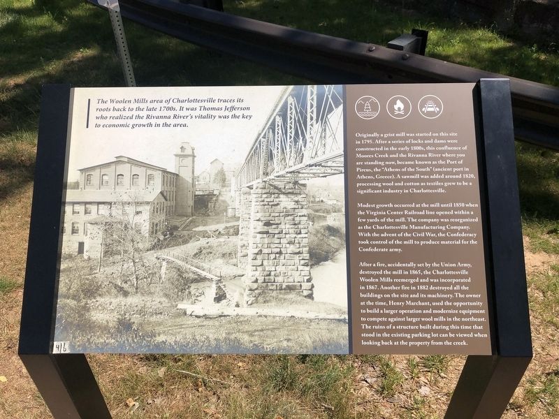
The Woolen Mills area of Charlottesville traces its roots back to the late 1700s. It was Thomas Jefferson who realized the Rivanna River's vitality was the key to economic growth in the area.
Originally a grist mill was started on this site in 1795. After a series of locks and dams were constructed in the early 1800s, this confluence of Moores Creek and the Rivanna River where you are standing now, became known as the Port of Pireus, the "Athens of the South" ancient port in Athens, Greece). A sawmill was added around 1820, processing wool and cotton as textiles grew to be a significant industry in Charlottesville.
Modest growth occurred at the mill until 1850 when the Virginia Center Railroad line opened within a few yards of the mill. The company was reorganized as the Charlottesville Manufacturing Company. With the advent of the Civil War, the Confederacy took control of the mill to produce material for the Confederate army.
After a fire, accidentally set by the Union Army, destroyed the mill in 1865, the Charlottesville Woolen Mills reemerged and was incorporated in 1867. Another fire in 1882 destroyed all the buildings on the site and its machinery. The owner at the time, Henry Marchant, used the property to build a larger operation and modernize equipment to compete against larger wool mills in the northeast. The ruins of a structure built during this time that stood in the existing parking lot can be viewed when looking back at the property from the creek.
Topics. This historical marker is listed in these topic lists: Industry & Commerce • War, US Civil • Waterways & Vessels. A significant historical year for this entry is 1795.
Location. 38° 1.168′ N, 78° 27.311′ W. Marker is near Charlottesville, Virginia, in Albemarle County. It is in Woolen Mills. Marker is on East Market Street (County Road 1105) 0.2 miles south of Riverside Avenue, on the right when traveling east. Touch for map. Marker is at or near this postal address: 1837 Broadway St, Charlottesville VA 22902, United States of America. Touch for directions.
Other nearby markers. At least 8 other markers are within walking distance of this marker. A different marker also named The Woolen Mills (within shouting distance of this marker); a different marker also named The Woolen Mills (about 400 feet away, measured in a direct line); Charlottesville Woolen Mills (approx. 0.2 miles away); Riverview Park (approx. 0.3 miles away); Woolen Mills Village Historic District (approx. 0.3 miles away); North Terrace Wing (approx. 0.6 miles away); Barrier (approx. 0.6 miles away); Ice House (approx. 0.6 miles away). Touch for a list and map of all markers in Charlottesville.
Credits. This page was last revised on August 20, 2023. It was originally submitted on May 10, 2021, by Devry Becker Jones of Washington, District of Columbia. This page has been viewed 279 times since then and 32 times this year. Photos: 1, 2. submitted on May 10, 2021, by Devry Becker Jones of Washington, District of Columbia.

