Defiance Rotary Club 75th Anniversary
1921 - 1996
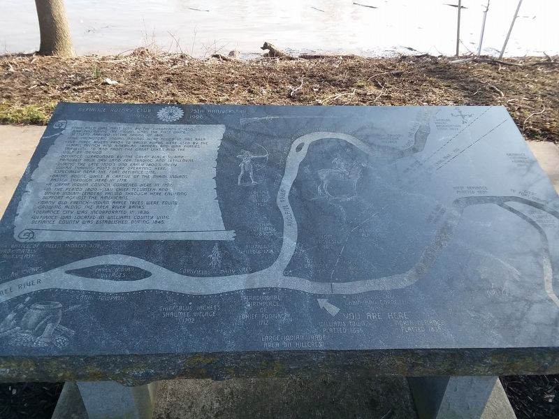
• This area was first seen by the Europeans c. 1650, and following the Indian Wars, the first white settlers arrived in the spring of 1815.
• Five prehistoric Indian mounds were found in this area.
• The three rivers, prior to paved roads, were used by the Indian, French and American Traders and War Parties, traveling to and from the Great Lakes and the Gulf of Mexico.
• Defiance, surrounded by the Great Black Swamp, provided high dry land for trading and settlement.
• During the late 1700's and early 1800's, many indicted trading posts were operating here, especially near the Fort Defiance site.
• Daniel Boone, while a captive of the Miami Indians, passed through here in 1778.
• A great Indian council convened here in 1792.
• In the period 1809 other Indian leaders passed through here enlisting support against the Americans.
• Many old French-Indian apple trees were found growing along the area river banks.
• Defiance City was incorporated in 1836.
• Defiance was located in Williams County until Defiance County was established during 1845.
Erected 1996 by Defiance Rotary Club.
Topics and series.
this page online
Location. 41° 17.358′ N, 84° 21.515′ W. Marker is in Defiance, Ohio, in Defiance County. It is on East River Drive (Ohio Route 424) 0.2 miles east of Clinton Street ( Route 18), on the right when traveling east. Touch for map. Marker is at or near this postal address: 123 E River Dr, Defiance OH 43512, United States of America. Touch for directions.

Regionally, this marker is in the Black Swamp and in the Till Plains. It is also in the American Midwest and in the Corn Belt. Globally, it is in North America, the Western Hemisphere, the Western World, and the Anglosphere. Historically, it finds itself in what was once the Haudenosaunee (Iroquois) Confederacy, the territory of the Mississippian Culture, and the Northwest Territory.
Other nearby markers. At least 8 other markers are within walking distance of this marker: You Are On The Buckeye Trail (here, next to this
Credits. This page was last revised on May 12, 2021. It was originally submitted on May 10, 2021, by Craig Doda of Napoleon, Ohio. This page has been viewed 317 times since then and 25 times this year. Photos: 1, 2. submitted on May 10, 2021, by Craig Doda of Napoleon, Ohio. • Devry Becker Jones was the editor who published this page.
