Port Townsend in Jefferson County, Washington — The American West (Northwest)
Union Wharf
⎯⎯⎯
Indian Island
The čičməhán Trail Stop 7
Photographed by William Fischer, Jr., August 2, 2021
1. Union Wharf / Indian Island Marker
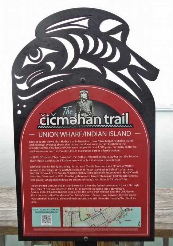
Looking south, view Kilisut Harbor and Indian Island, now Naval Magazine Indian Island. Archeological evidence shows that Indian Island was an important location to the ancestors of the S’Klallam and Chimacum people for over 1,500 years. For many centuries, sea level was as much as 7 meters lower than today, making the harbor a fertile wetland.
In 1870,čičməhán (Cheech-ma-han) met with a Territorial delegate, asking that the Tribe be given Indian Island as the S’Klallam reservation, but that request was denied.
čičməhán and his family, including his two sons Charlie Swan York and "Prince of Wales," moved to the village at the northeast corner of Indian Island called šéʔnəkw, after being forcibly removed to the S'Klallam Indian Agency (the Skokomish Reservation in Hood Canal) from Port Townsend in 1871. Also living there were James (Chimacum Jim) Webster and his wife Louise, whose descendants are citizens of today's Port Gamble S'Klallam Tribe.
Indian-owned lands on Indian Island were lost when the federal government took it through the Eminent Domain process in 1939-41, to convert
this page online
Erected 2019 by Native Connections Action Group of the Quimper Unitarian Universalist Fellowship, the Jamestown S'Klallam Tribe, and Others.
Topics and series. This historical marker is listed in these topic lists: Environment • Indigenous Peoples and Communities • Waterways & Vessels. In addition, it is included in the The Čičməhán Trail, Port Townsend, Washington series list. A significant historical year for this entry is 1870.
Location. 48° 6.795′ N, 122° 45.336′ W. Marker is in Port Townsend, Washington, in Jefferson County. It can be reached from Taylor Street. Marker is at the Union Wharf pavilion, at the south end of Taylor Street. Touch for map. Marker is in this post office area: Port Townsend WA 98368, United States of America. Touch for directions.

Regionally, this marker

Photographed by William Fischer, Jr., August 2, 2021
2. Union Wharf / Indian Island Marker
Other nearby markers. At least 8 other markers are within walking distance of this marker: Port Townsend's Waterfront (a few steps from this marker); Bounty of the Bay (a few steps from this marker); Union Wharf: A Century of Continuous Service (within shouting distance of this marker); Welcome to Port Townsend: Washington's Victorian Seaport (within shouting distance of this marker); Union Wharf (about 400 feet away, measured in a direct line); Hastings Building (about 400 feet away); The Belmont (about 500 feet away); Citizens Independent Telephone Company (about 500 feet away). Touch for a list and map of all markers in Port Townsend.
Also see . . .
1. čičməhán Trail (Jamestown S'Klallam Tribe). (Submitted on August 16, 2021, by William Fischer, Jr. of Reynoldsburg, Ohio.)
2. Jamestown S'Klallam Tribe. (Submitted on August 16, 2021, by William Fischer, Jr. of Reynoldsburg, Ohio.)
Credits. This page was last revised on May 11, 2025. It was originally submitted on August 16, 2021, by William Fischer, Jr. of Reynoldsburg, Ohio. This page has been viewed 442 times since then and 56 times this year. Photos: 1, 2. submitted on August 16, 2021, by William Fischer, Jr. of Reynoldsburg, Ohio.
