Auburn in Androscoggin County, Maine — The American Northeast (New England)
Wabanaki History
⎯⎯⎯
Les Wabanaquis
Auburn, Maine
| — | The Museum in the Streets | — |
Photographed by Devry Becker Jones (CC0), November 11, 2021
1. Wabanaki History / Les Wabanaquis Marker

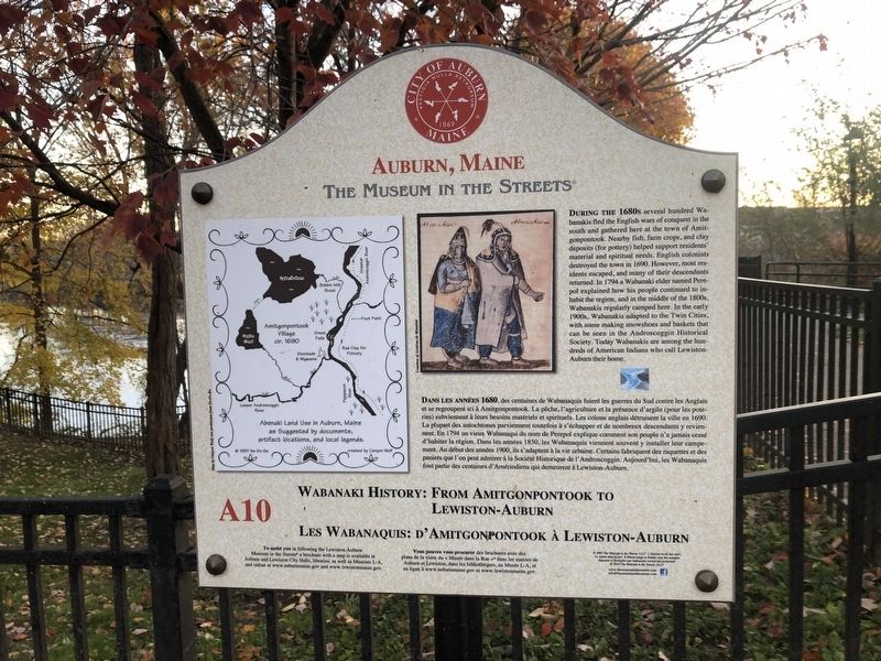
Wabanaki History: From Amitgonpontook to Lewiston-Auburn
During the 1680s several hundred Wabanakis fled the English wars of conquest in the south and gathered here at the town of Amitgonpontook. Nearby fish, farm crops, and clay deposits (for pottery) helped support residents' material and spiritual needs. English colonists destroyed the town in 1690. However, most residents escaped, and many of their descendants returned. In 1794 a Wabanaki elder named Perepol explained how his people continued to inhabit the region, and in the middle of the 1800s, Wabanakis regularly camped here. In the early 1900s, Wabanakis adapted to the Twin Cities, with some making snowshoes and baskets that can be seen in the Androscoggin Historical Society. Today Wabanakis are among the hundreds of American Indians who call Lewiston-Auburn their home.
Dan les années 1680, des centaines de Wabanaquis fuient le guerres du Sud contre les Anglais et se regroupent ici à Amitgonpontook. La pêche, l'agriculture et la présence d'argile (pour les poteries) subviennant à leurs besoins matérials
this page online
Erected 2019 by The Museum in the Streets. (Marker Number A10.)
Topics and series. This historical marker is listed in these topic lists: Colonial Era • Indigenous Peoples and Communities • Settlements & Settlers • Wars, Non-US. In addition, it is included in the The Museum in the Streets: Auburn-Lewiston, Maine series list. A significant historical year for this entry is 1690.
Location. 44° 5.539′ N, 70° 13.5′ W. Marker is in Auburn, Maine, in Androscoggin County. It is on Auburn Riverwalk
Photographed by Devry Becker Jones (CC0), November 11, 2021
2. Wabanaki History / Les Wabanaquis Marker

Regionally, this marker is in the American Northeast and in New England. Globally, it is in North America, the Western Hemisphere, the Western World, and the Anglosphere.
Other nearby markers. At least 8 other markers are within walking distance of this marker: Bonney Park (here, next to this marker); a different marker also named Bonney Park (here, next to this marker); Cities of the Androscoggin (a few steps from this marker); River Pollution and Restoration / Pollution et Restoration de la Rivière (about 300 feet away, measured in a direct line); Lewiston Falls Academy / L'Académie de Lewiston Falls (about 300 feet away); Development of New Auburn / Le Nouvel Auburn (about 400 feet away); 10,000 Years of Wabanaki History / 10 000 Ans d'Histoire Wabanaki (about 600 feet away); a different marker also named Cities of the Androscoggin (about 600 feet away). Touch for a list and map of all markers in Auburn.
Credits. This page was last revised on August 26, 2026. It was originally submitted on November 16, 2021, by Devry Becker Jones of Washington, District of Columbia. This page has been viewed 650 times since then and 75 times this year. Photos: 1, 2. submitted on November 16, 2021, by Devry Becker Jones of Washington, District of Columbia.
