Kennebunk in York County, Maine — The American Northeast (New England)
The Mousam River
⎯⎯⎯
Le Fleuve Mousam
Kennebunk, ME
| — | The Museum in the Streets | — |
Photographed by Devry Becker Jones (CC0), November 14, 2021
1. The Mousam River / Le Fleuve Mousam Marker

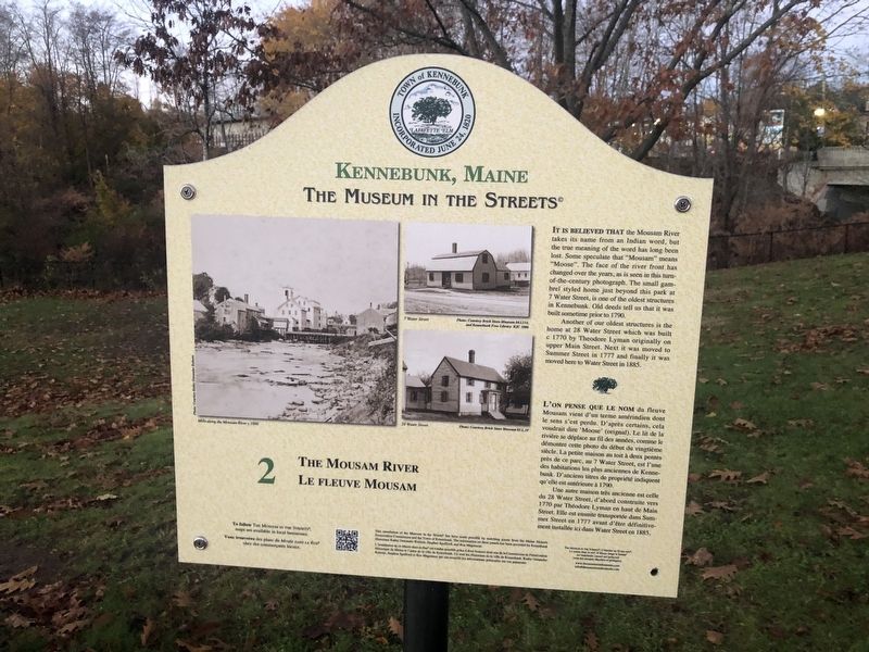
It is believed that the Mousam River takes its name from an Indian word, but the true meaning of the word has long been lost. Some speculate that “Mousam” means “Moose”. The face of the river front has changed over the years, as is seen in this turn-of-the-century photograph. The small gambrel styled home just beyond this park at 7 Water Street, is one of the oldest structures in Kennebunk. Old deeds tell us that it was built sometime prior to 1790.
Another of our oldest structures is the home at 28 Water Street which was built c 1770 by Theodore Lyman originally on upper Main Street. Next it was moved to Summer Street in 1777 and finally it was moved here to Water Street in 1885.
this page online
Une autre maison très ancienne est celle du 28 Water Street, d’abord construite vers 1770 par Théodore Lyman en haut de Main Street. Elle est ensuite transportée dans Summer Street en 1777 avant d’être définitivement installée ici dans Water Street en 1885.
Erected by The Museum in the Streets. (Marker Number 2.)
Topics and series. This historical marker is listed in these topic lists: Architecture • Colonial Era • Indigenous Peoples and Communities • Waterways & Vessels. In addition, it is included in the The Museum in the Streets: Kennebunk, Maine series list. A significant historical year for this entry is 1790.
Location. 43° 23.094′ N, 70° 32.497′ W. Marker is in Kennebunk, Maine, in York County. It is on Water Street just south of York Street (U.S. 1), on the right when traveling south. Touch for map. Marker is at or near this postal address: 16 Water St, Kennebunk ME 04043, United States of America. Touch for directions.

Regionally, this marker is on Southern Maine Coast. It is also in the American Northeast, in New England, and on the Eastern Seaboard. Globally, it is
Photographed by Devry Becker Jones (CC0), November 14, 2021
2. The Mousam River / Le Fleuve Mousam Marker
Other nearby markers. At least 8 other markers are within walking distance of this marker: Kennebunk Rotary Club (within shouting distance of this marker); Kennebunk, Maine (within shouting distance of this marker); The Lafayette Center / Le Centre Lafayette (within shouting distance of this marker); The Ross Block and The Kennebunk Inn / Le Bâtiment Ross et l'Auberge de Kennebunk (about 500 feet away, measured in a direct line); Waterhouse Center (about 600 feet away); Lafayette Elm Site (about 800 feet away); The Bourne Mansion / La Résidence Bourne (approx. 0.2 miles away); The Horace Porter Home / La Maison d'Horace Porter (approx. 0.2 miles away). Touch for a list and map of all markers in Kennebunk.
Another marker is no longer nearby. The Storer Residence / La Résidence Storer (was about 800 feet away but has been replaced with another marker now near it).
Credits. This page was last revised on November 20, 2021. It was originally submitted on November 20, 2021, by Devry Becker Jones of Washington, District of Columbia. This page has been viewed 643 times since then and 57 times this year. Photos: 1, 2. submitted on November 20, 2021, by Devry Becker Jones of Washington, District of Columbia.
