Wells in York County, Maine — The American Northeast (New England)
Laudholm Farm: The foundation of the Wells Reserve

Photographed By Devry Becker Jones (CC0), November 15, 2021
1. Laudholm Farm: The foundation of the Wells Reserve Marker
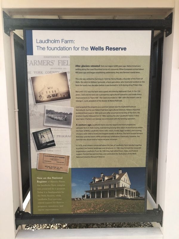
After glaciers retreated from our region 6,000 years ago, Native Americans settling along the coast flourished on its rich resources. When Europeans arrived about 400 years ago and began establishing settlements, they also favored coastal areas.
This site was settled for farming in 1643 by Henry Boade, a founder of the Town of Wells. He sold it to William Symonds, a land speculator, who lived and worked on the farm for nearly two decades before it was burned in 1676 during King Philip's War.
Not until 1717 was the farm reoccupied, this time by Nathaniel Clark, Jr. For 150 years, Clark and his heirs ran a prosperous agricultural occupation and made many improvements to "Farm Hill." The Clark era ended in 1881 with the estate's sale to George C. Lord, president of the Boston & Maine Railroad.
Lord acquired the property as a summer retreat area near his boyhood home in Kennebunk, but his son Robert had keen agricultural interests. Robert imported purebred Guernseys in 1892 and soon after assumed ownership of the farm. His brother Charles followed him in 1908, naming the site "Laudholm Farms." A few years later, Charles's son George was entrusted with the farming operation.
A century ago, Laudholm Farms was the largest and most progressive saltwater farm in York County, maintaining its long-time place of prominence within the Town of Wells, Laudholm Farms milk, cream, butter, eggs, broilers, and roasting chickens were sold to locals and shipped weekly to Boston. The farm hosted farmers' field days and the town's 300th anniversary celebration. Eventually, however, the farm fell into disuse and its future became uncertain.
In 1978, local citizens concerned about the fate of Laudholm Farm banded together to protect the historic landscape and structures. In 1982 they formed the nonprofit organization Laudholm Trust. By 1986 they had rallied Town, State, and Federal support, formed key partnerships, and celebrated the dedication of the Wells National Estuarine Research Reserve.
Now on the National Register of Historic Places, the Laudholm Farm complex was preserved for a purpose. Today it is headquarters for the Wells Reserve, while Laudholm Trust provides critical support for Reserve programs, operations, and capital improvements.
Topics. This historical marker is listed in these topic lists: Agriculture • Animals • Colonial Era • Native Americans • Settlements & Settlers • Waterways & Vessels. A significant historical year for this entry is 1643.
Location. 43° 20.298′ N, 70° 33.049′ W. Marker is in Wells, Maine, in York County. Marker can be reached

Photographed By Devry Becker Jones (CC0), November 15, 2021
2. Laudholm Farm: The foundation of the Wells Reserve Marker
Other nearby markers. At least 8 other markers are within walking distance of this marker. Hay and Horse Barn (within shouting distance of this marker); Ice House (within shouting distance of this marker); Water Tower (within shouting distance of this marker); Cow Barn (about 300 feet away, measured in a direct line); Farmhouse (about 400 feet away); Creamery (about 400 feet away); Welcome to the 'Sense of Wonder' Rain Garden… (approx. 0.6 miles away); Rachel Carson (approx. 0.6 miles away). Touch for a list and map of all markers in Wells.
Credits. This page was last revised on November 22, 2021. It was originally submitted on November 22, 2021, by Devry Becker Jones of Washington, District of Columbia. This page has been viewed 403 times since then and 90 times this year. Photos: 1, 2. submitted on November 22, 2021, by Devry Becker Jones of Washington, District of Columbia.