Bel Alton in Charles County, Maryland — The American Northeast (Mid-Atlantic)
Archaeology Provides a Key to the History of Rich Hill

Photographed By Devry Becker Jones (CC0), November 25, 2021
1. Archaeology Provides a Key to the History of Rich Hill Marker
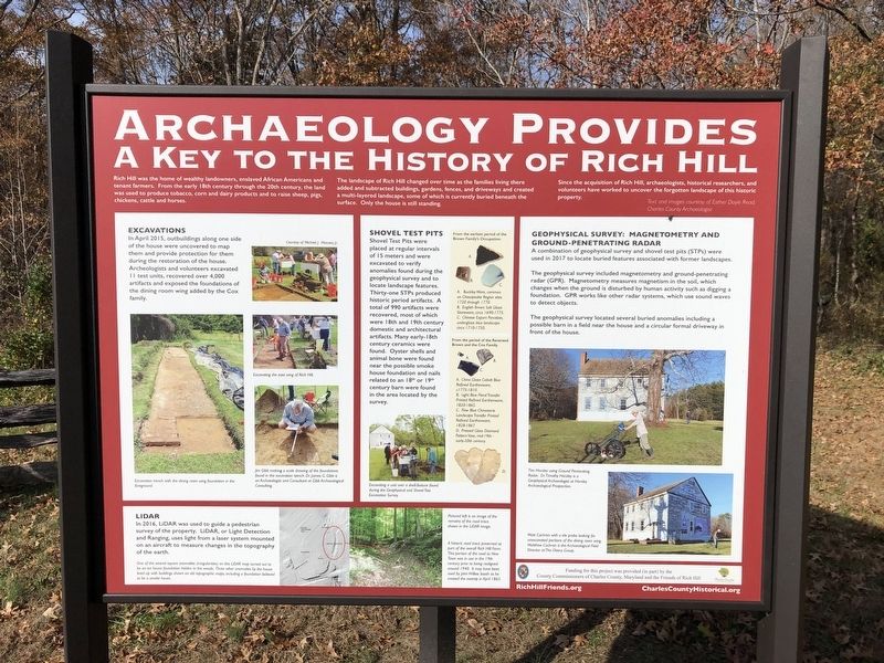
Rich Hill was the home of wealthy landowners, enslaved African Americans and tenant farmers. From the early 18th century through the 20th century, the land was used to produce tobacco, corn and dairy products and to raise sheep, pigs, chickens, cattle and horses.
The landscape of Rich Hill changed over time as the families living there added and subtracted buildings, gardens, fences, and driveways and created a multi-layered landscape, some of which is currently buried beneath the surface. Only the house is still standing.
Since the acquisition of Rich Hill, archaeologists, historical researchers, and volunteers have worked to uncover the forgotten landscape of this historic property.
Excavations
In April 2015, outbuildings along one side of the house were uncovered to map them and provide protection for them during the restoration of the house. Archeologists and volunteers excavated 11 test units, recovered over 4,000 artifacts and exposed the foundations of the dining room wing added by the Cox family.
Shovel Test Pits
Shovel Test Pits were placed at regular intervals of 15 meters and were excavated to verify anomolies found during the geophysical survey and to locate lands features. Thirty-one STPs produced historic period artifacts. A total of 990 artifacts were recovered, most of which were 18th and 19th century domestic and architectural artifacts. Many early-18th century ceramics were found. Oyster shells and animal bone were found near the possible smoke house foundation and nails related to an 18th or 19th century barn were found in the area located by the survey.
Geophysical Survey: Magnetometry and Ground-Penetrating Radar
A combination of geophysical survey and shovel test pits (STPs) were used in 2017 to locate buried features associated with former landscapes.
The geophyiscal survey included magnetometry and ground-penetrating radar (GPR). Magnetometry measures magnetism in the soil, which changes when the ground is disturbed by human activity such as digging a foundation. GPR works like other radar systems, which use sound waves to detect objects.
The geophysical survey located several buried anomalies including a possible barn in a field near the house and a circular formal driveway in front of the house.
LiDAR
In 2016, LiDAR was used to guide a pedestrian survey of the property. LiDAR, or Light Detection and Ranging, uses light from a laser system mounted on an aircraft to measure changes in the topography of the earth.
Erected by the County Commissioners of Charles County, Maryland and the Friends

Photographed By Devry Becker Jones (CC0), November 25, 2021
2. Archaeology Provides a Key to the History of Rich Hill Marker
Topics. This historical marker is listed in these topic lists: African Americans • Agriculture • Animals • Anthropology & Archaeology • Colonial Era. A significant historical month for this entry is April 2015.
Location. 38° 28.288′ N, 76° 57.939′ W. Marker is in Bel Alton, Maryland, in Charles County. Marker can be reached from Bel Alton Newtown Road, 0.1 miles east of Rich Hill Farm Road, on the left when traveling east. Touch for map. Marker is at or near this postal address: 9135 Bel Alton Newtown Rd, Bel Alton MD 20611, United States of America. Touch for directions.
Other nearby markers. At least 8 other markers are within 2 miles of this marker, measured as the crow flies. Rich Hill Farm in the 19th Century: Samuel Cox and his Award-Winning Farm (here, next to this marker); Rich Hill Farm in the 20th Century (here, next to this marker); Rich Hill (within shouting distance of this marker); Rich Hill Through the Years (within shouting distance of this marker); a different marker also named Rich Hill (about 400 feet away, measured in a direct line); John Wilkes Booth and David Herold (approx. 1.2 miles away); Pine Thicket (approx. 1.2 miles away); John Wilkes Booth (approx. 1.3 miles away). Touch for a list and map of all markers in Bel Alton.
Credits. This page was last revised on November 25, 2021. It was originally submitted on November 25, 2021, by Devry Becker Jones of Washington, District of Columbia. This page has been viewed 193 times since then and 17 times this year. Photos: 1, 2. submitted on November 25, 2021, by Devry Becker Jones of Washington, District of Columbia.