
White Sulphur Springs in Greenbrier County, West Virginia — The American South (Appalachia)
Kate's Mountain
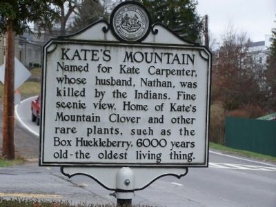
Photographed by Beverly Pfingsten, March 27, 2009
1. Kate's Mountain Marker
Topics and series. This historical marker is listed in these topic lists: Agriculture • Environment • Horticulture & Forestry • Settlements & Settlers • Wars, US Indian • Women. In addition, it is included in the West Virginia Archives and History series list.
Location. 37° 47.091′ N, 80° 18.371′ W. Marker is in White Sulphur Springs, West Virginia, in Greenbrier County. It is at the intersection of U.S. 60 and Kate's Mountain Rd. on U.S. 60. Touch for map. Marker is in this post office area: White Sulphur Springs WV 24986, United States of America. Touch for directions.

Regionally, this marker is in the Southern Coalfields. It is also in the American South, specifically in the Upper South, in Appalachia, and specifically in Southern Appalachia. Globally, it is in North America, the Western Hemisphere, the Western World,
this page online
Other nearby markers. At least 8 other markers are within walking distance of this marker: White Sulphur (about 700 feet away, measured in a direct line); The Greenbrier Clinic and Project Greek Island (about 800 feet away); The Old White (approx. ¼ mile away); Katherine Johnson (approx. 0.3 miles away); President's Cottage (approx. 0.4 miles away); The Springhouse (approx. 0.4 miles away); Tennis and the Outdoor Swimming Pool (approx. 0.4 miles away); a different marker also named The Springhouse (approx. 0.4 miles away). Touch for a list and map of all markers in White Sulphur Springs.
Also see . . . Box Huckleberry. (Submitted on May 25, 2009, by Bill Pfingsten of Bel Air, Maryland.)
Credits. This page was last revised on June 8, 2020. It was originally submitted on May 25, 2009, by Bill Pfingsten of Bel Air, Maryland. This page has been viewed 3,275 times since then and 37 times this year. Photo 1. submitted on May 25, 2009, by Bill Pfingsten of Bel Air, Maryland.
