Gilroy in Santa Clara County, California — The American West (Pacific Coastal)
Uvas Creek
El arroyo de las Uvas
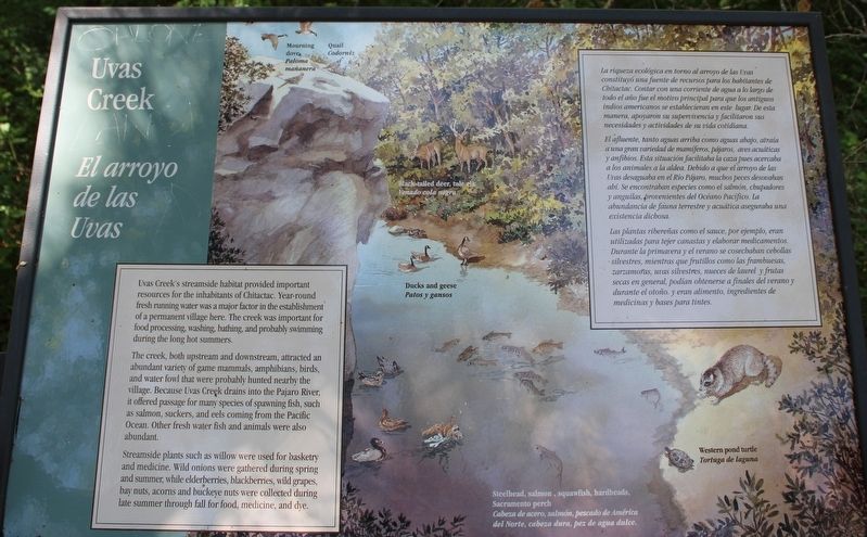
Uvas Creek's streamside habitat provided important resources for the inhabitants of Chitactac. Year-round fresh running water was a major factor in the establishment of a permanent village here. The creek was important for food processing, washing, bathing, and probably swimming during the long hot summers.
The creek, both upstream and downstream, attracted an abundant variety of game mammals, amphibians, birds, and waterfowl that were probably hunted nearby the village. Because Uvas Creek drains into the Pajaro River, it offered passage for many species of spawning fish, such as salmon, suckers, and eels coming from the Pacific Ocean. Other Fresh water fish and animals were also abundant.
Streamside plants such as willow were used for basketry and medicine. Wild onions were gathered during spring and summer, while elderberries, blackberries, wild grapes, bay nuts, acorns and buckeye nuts were collected during late summer through fall for food, medicine, and dye.
El afluente, tanto aguas arriba como aguas abajo, atraía a una gran variedad de mamíferos, pájaros, aves acuáticas y anfibios. Esta situación facilitaba la caza pues acercaba a los animales a la aldea. Debido a que el arroyo de las Uvas desaguaba en el Río Pájaro, muchos peces desovaban ahí. Se encontraban especies como el salmón, chupadores y anguilas, provenientes del Océan Pacífico. La abundancia de fauna terrestre y acuática asegurabauna existencia dichosa.
Las plantas ribereñas como al sauce, por ejemplo, eran utilizadas para tejer canastas y elaborar medicamentos. Durante la primavera y el verano se cosechaban cebollas silvestres, mientras que frutillos como las frambuesas, zarzamoras, uvas silvestres, nueces de laurel y frutas secas en general podían obtenerse a finales del verano y durante el otoño. y eran alimento, ingredientes de medicinas y bases para tintes.
Topics. This historical marker is listed in these topic lists: Animals • Anthropology & Archaeology • Native Americans • Parks & Recreational Areas • Waterways & Vessels.
Location. 37° 1.811′ N, 121° 39.436′ W. Marker is in Gilroy, California, in Santa Clara County. Marker can be reached from the intersection of Watsonville Road (County Road G8) and Burchell Road, on the right when traveling south. The marker is mounted to a metal stand on the trail below the parking lot of the Chitactac-Adams Heritage County Park. Touch for map. Marker is at or near this postal address: 10001 Watsonville Road, Gilroy CA 95020, United States of America. Touch for directions.
Other nearby markers. At least 8 other markers are within walking distance of this marker. Arrival of the Spanish (a few steps from this marker); Food Processing (within shouting distance of this marker); Chitactac-Adams Heritage County Park (within shouting distance of this marker); A journey of a Lifetime (within shouting distance of this marker); School Days (within shouting distance of this marker); Ranchos and Growth (about 300 feet away, measured in a direct line); Ohlone Buildings (about 300 feet away); Rock Art (about 400 feet away). Touch for a list and map of all markers in Gilroy.
Also see . . . Chitactac-Adams Heritage County Park.
"This beautiful and culturally significant 4.5 acre park site is located just minutes from the cities of Gilroy and Morgan Hill."(Submitted on May 23, 2022, by Joseph Alvarado of Livermore, California.)
Credits. This page was last revised on May 24, 2022. It was originally submitted on May 23, 2022, by Joseph Alvarado of Livermore, California. This page has been viewed 149 times since then and 16 times this year. Photo 1. submitted on May 23, 2022, by Joseph Alvarado of Livermore, California. • Devry Becker Jones was the editor who published this page.
