Washington Township near Piqua in Miami County, Ohio — The American Midwest (Great Lakes)
Battle of Pickawillany
1752
| — | Ohio Historical Marker | — |
Photographed by Dale K. Benington, June 5, 2009
1. Battle of Pickawillany Marker
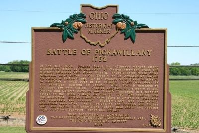
In the mid-1700s, France found its influence waning among midwestern tribes as it contested for Native American trade and military alliances with Great Britain. Shortly after Miami Chief Memeskia (also known as Old Britain or La Demoiselle) moved his village to Pickawillany, British traders were given permission to establish a small post in the village, which was deep in the territory claimed by France. When French demands to evacuate the post failed, Charles Langlade led a party of 250 Ottawa and Ojibwa warriors and French Canadians in a surprise attack on the Miami village on June 21, 1752. The trading post was destroyed, British traders were taken to Detroit as prisoners, and Memeskia was executed. Pickawillany was completely abandoned soon after. As a prelude to the French and Indian War, the Battle of Pickawillany fueled land claim and trading right conflicts between France and Britain.
Erected 2003 by The Marietta Chapter NSDAR Piqua Historical Area and the Ohio Historical Society. (Marker Number 6-55.)
Topics and series. This historical marker is listed in these topic lists: Colonial Era • Indigenous Peoples and Communities
this page online
Location. Marker has been reported missing. It was located near 40° 10.771′ N, 84° 15.745′ W. Marker was near Piqua, Ohio, in Miami County. It was in Washington Township. It was on North Hardin Road 0.1 miles north of Ohio Route 66, on the right when traveling north. This historical marker is located immediately in front of the Piqua Historic Area, which is a property owned and maintained by the Ohio Historical Society. Touch for map. Marker was at or near this postal address: 9845 N Hardin Rd, Piqua OH 45356, United States of America. Touch for directions.

Regionally, this marker was in Ohio’s Dayton Metro, in the Miami Valley, and in the Till Plains. It was also in the American Midwest and in the Corn Belt. Globally, it was in North America, the Western Hemisphere, the Western World, and the Anglosphere. Historically, it found itself in what was once the Haudenosaunee (Iroquois) Confederacy,
Photographed by Dale K. Benington, June 5, 2009
2. Battle of Pickawillany Marker
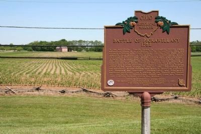
View of historic marker in right foreground and Piqua Historic Area and John Johnston's house in the left-center distant background.
Other nearby markers. At least 8 other markers are within walking distance of this location: Pickawillany (here, next to this marker); In Commemoration of the 94th & 110th Reg’s. O.V.I. (here, next to this marker); Public History Movement (here, next to this marker); Indian Agency House (a few steps from this marker); Johnston Barn (approx. ¼ mile away); Prehistoric Indian Mound (approx. ¼ mile away); The Cider House (approx. ¼ mile away); The Courtyard (approx. ¼ mile away). Touch for a list and map of all markers in Piqua.
Other markers no longer nearby. John Johnston (was here, next to this marker but has been confirmed missing); Fort Pickawillany (was here, next to this marker but has been confirmed missing).
Also see . . . Piqua Historic Area. This web link was both published and made available by, "Touring Ohio." (Submitted on June 12, 2009, by Dale K. Benington of Toledo, Ohio.)

Photographed by Trevor L Whited, July 13, 2025
3. Battle of Pickawillany Marker
The post remains, but marker is missing
Credits. This page was last revised on July 16, 2025. It was originally submitted on June 11, 2009, by Dale K. Benington of Toledo, Ohio. This page has been viewed 4,060 times since then and 129 times this year. Last updated on July 13, 2025, by Trevor L Whited of Kokomo, Indiana. Photos: 1, 2. submitted on June 11, 2009, by Dale K. Benington of Toledo, Ohio. 3. submitted on July 13, 2025, by Trevor L Whited of Kokomo, Indiana. • Devry Becker Jones was the editor who published this page.
