
Halifax in Halifax County, North Carolina — The American South (South Atlantic)
Escape!
The Roanoke River, Halifax, and the Maritime Underground Railroad.
Photographed by Bernard Fisher, October 13, 2022
1. Escape! Marker
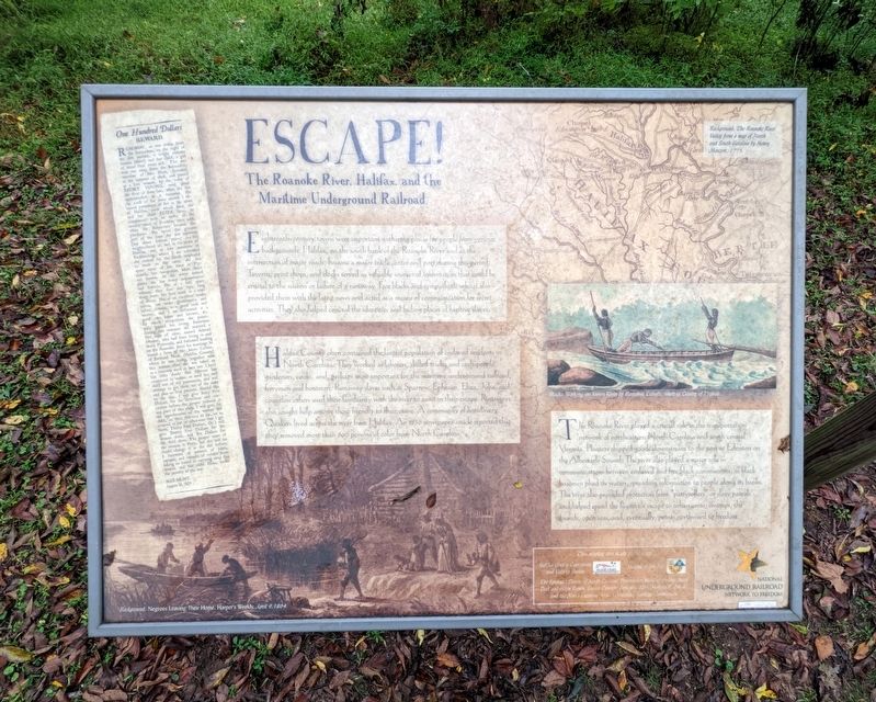
Eighteenth-century towns were important gatherinsg spaces for people from various backgrounds. Halifax, on the south bank of the Roanoke River and at the intersection of major roads, became a major trade center and port during this period. Taverns, print shops, and docks served as valuable sources of information that could be crucial to the success or failure of a runaway. Free blacks and sympathetic whites also provided them with the latest news and acted as a means of communication for secret activities. They also helped conceal the identities and hiding places of fugitive slaves.
Halifax County often contained the largest population of enslaved residents in North Carolina. They worked as laborers, skilled trades, and craftspeople, gardeners, cooks, and, perhaps most important for the maritime underground railroad, ferrymen and boatmen. Runaway slaves such as Sparrow, Ephraim, Eliza, Juba, and countless others used their familiarity with the river to assist in their escape. Runaways also sought help among those friendly to their cause. A community of antislavery Quakers lived aross the river from Halifax. An 1830
this page online
The Roanoke River played a crucial role in the transportation of network of northeastern North Carolina and south central Virginia. Planters shipped goods downstream to the port at Edenton on the Albemarle Sound. The river also played a major role communications between enslaved and free black communities, as black boatmen plied the waters, spreading information to people along its banks. The river also provided protection from "pattyrollers" or slave patrols and helped speed the fugitive's escape to urban areas, swamps, the sounds, open seas, and, eventually, points northward to freedom.
Erected by National Underground Railroad Network to Freedom.
Topics. This historical marker is listed in these topic lists: Abolition & Underground RR • African Americans • Law Enforcement • Waterways & Vessels. A significant historical year for this entry is 1830.
Location. 36° 19.978′ N, 77° 34.991′ W. Marker is in Halifax, North Carolina, in Halifax County. It is on King Street north of Fishing Club Road, on the left when traveling north.
Photographed by Bernard Fisher, October 13, 2022
2. Escape! Marker

Regionally, this marker is in North Carolina’s Coastal Plain. It is also in the American South and specifically in the Upper South. Globally, it is in North America, the Western Hemisphere, the Western World, and the Anglosphere. Historically, it finds itself in what was once the territory of the Mississippian Culture, one of the original Thirteen Colonies, one of the Confederate States of America, and the Antebellum South.
Other nearby markers. At least 8 other markers are within walking distance of this marker: Halifax Runaway Ads (approx. 0.2 miles away); a different marker also named Escape! (approx. 0.2 miles away); The Sally Billy House (approx. ¼ mile away); Montfort Archaeological Museum (approx. ¼ mile away); The Free Church of Halifax (approx. 0.3 miles away); The Market Green (approx. 0.3 miles away); Halifax Courthouse (approx. 0.3 miles away); Site of First Courthouse (approx. 0.3 miles away). Touch for a list and map of all markers in Halifax.
Credits. This page was last revised on October 14, 2022. It was originally submitted on October 14, 2022, by Bernard Fisher of Richmond, Virginia. This page has been viewed 284 times since then and 18 times this year. Photos: 1, 2. submitted on October 14, 2022, by Bernard Fisher of Richmond, Virginia.
