Watertown in Carver County, Minnesota — The American Midwest (Upper Plains)
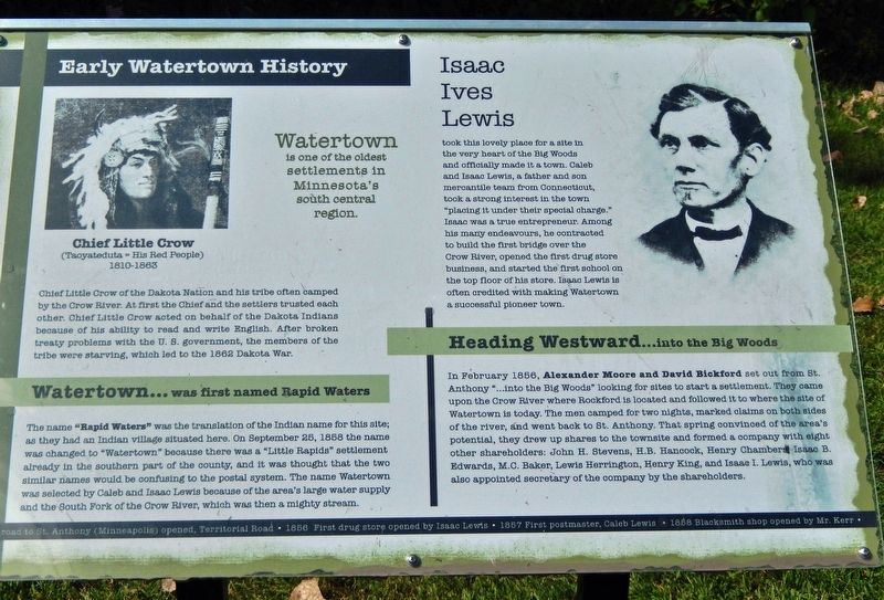
Early Watertown History
Photographed by Cosmos Mariner, September 2, 2022
1. Early Watertown History Marker
Watertown
is one of the oldest settlements in Minnesota’s south central region.
Chief Little Crow
of the Dakota Nation and his tribe often camped by the Crow River. At first the Chief and the settlers trusted each other. Chief Little Crow acted on behalf of the Dakota Indians because of his ability to read and write English. After broken treaty problems with the U. S. government, the members of the tribe were starving, which led to the 1862 Dakota War.
Watertown... was first named Rapid Waters
The name "Rapid Waters" was the translation of the Indian name for this site; as they had an Indian village situated here. On September 25, 1858 the name was changed to "Watertown" because there was a "Little Rapids" settlement already in the southern part of the county, and it was thought that the two similar names would be confusing to the postal system. The name Watertown was selected by Caleb and Isaac Lewis because of the area's large water supply and the South Fork of the Crow River, which was then a mighty stream.
Isaac Ives Lewis
took this lovely place for a site in the very heart of the Big Woods and officially made it a town. Caleb
this page online
Heading Westward… into the Big Woods
In February 1856, Alexander Moore and David Bickford set out from St. Anthony "...into the Big Woods" looking for sites to start a settlement. They came upon the Crow River where Rockford is located and followed it to where the site of Watertown is today. The men camped for two nights, marked claims on both sides of the river, and went back to St. Anthony. That spring convinced of the area's potential, they drew up shares to the townsite and formed a company with eight other shareholders: John H. Stevens, H.B. Hancock, Henry Chambers, Isaac B. Edwards, M.C. Baker, Lewis Herrington, Henry King, and Isaac I. Lewis, who was also appointed secretary of the company by the

Photographed by Cosmos Mariner, September 2, 2022
2. Early Watertown History Marker
[timeline across bottom of marker]
• 1856 Road to St. Anthony (Minneapolis) opened, Territorial Road
• 1856 First drug store opened by Isaac Lewis
• 1857 First postmaster, Caleb Lewis
• 1858 Blacksmith shop opened by Mr. Kerr
Topics. This historical marker is listed in these topic lists: Indigenous Peoples and Communities • Settlements & Settlers • Wars, US Indian • Waterways & Vessels. A significant historical date for this entry is September 2, 1858.
Location. 44° 57.899′ N, 93° 50.681′ W. Marker is in Watertown, Minnesota, in Carver County. It can be reached from Mill Avenue Northeast 0.1 miles north of Carter Street Northeast, on the left when traveling north. Marker is located beside the pergola at the north end of the riverwalk. Touch for map. Marker is in this post office area: Watertown MN 55388, United States of America. Touch for directions.

Regionally, this marker is in the Minnesota River Valley and in the Twin Cities Metropolitan Area. It is also in the American Midwest and in the Corn Belt. Globally, it is in North America, the Western Hemisphere, the Western World, and the Anglosphere.

3. Marker detail: Chief Little Crow
1810-1863
Other nearby markers. At least 8 other markers are within 9 miles of this marker, measured as the crow flies: People & Places in Our History (within shouting distance of this marker); Watertown Pioneer Days (about 300 feet away, measured in a direct line); Lewis Avenue North Historic District (about 500 feet away); Dakota Rail History in Mayer (approx. 5.9 miles away); In Memory of All American Veterans (approx. 6.3 miles away); St. Bonifacius: A Cold War Battlefront (approx. 6.3 miles away); Nike Missiles: Dedicated to Defense (approx. 6.3 miles away); "Golden Buckle of the Dairy Belt" (approx. 8.3 miles away). Touch for a list and map of all markers in Watertown.
Also see . . . Watertown.
The town’s origins stretch back to 1851 with the creation of two treaties: the Treaty of Traverse des Sioux and the Treaty of Mendota. Through these treaties, American Indian bands of the Dakota tribe ceded much of their land in the central and western parts of the Minnesota Territory. Five years(Submitted on December 26, 2022, by Cosmos Mariner of Cape Canaveral, Florida.)later in 1856, two men named Alexander Moore and David Bickford arrived in the area that is known today as Watertown. Moore and Bickford were searching for suitable places to create towns. The two men followed the Crow River up to an area where there were many rapids within the river. Due to the rapids they found, the proto-town was given its first name: Rapid City. 4. Marker detail: Isaac Ives Lewis
Isaac Lewis was a friend and partner of David Bickford, which is how he learned of Rapid City. He decided to take it upon himself to create Watertown, with his own money and more from people he knew. Alexander Moore had created a sawmill in the fall of 1856 and in November of the same year, Lewis had created a small general goods store. At the same time, immigrants from Europe were settling into the area and Watertown truly began as we know it today.
Credits. This page was last revised on December 11, 2024. It was originally submitted on December 26, 2022, by Cosmos Mariner of Cape Canaveral, Florida. This page has been viewed 937 times since then and 133 times this year. Photos: 1, 2, 3, 4. submitted on December 26, 2022, by Cosmos Mariner of Cape Canaveral, Florida.
