Neighborhood Nine in Cambridge in Middlesex County, Massachusetts — The American Northeast (New England)
Cambridge Common
The Pasture
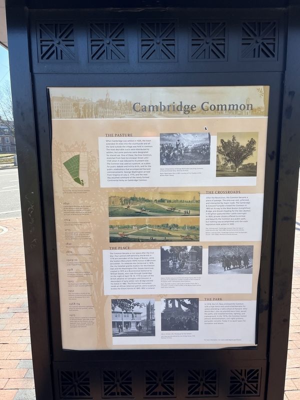
When Cambridge was settled in 1630, the town extended 35 miles into the countryside and all the land outside the village was held in common. The most desirable tracts were distributed to settlers, but some pastures were designated for shared use. One of these, the Cow Common, stretched from here to Linnaean Street until 1724 when it was reduced to its present size. The Common was used as a pasture, as a place for public debate and militia drills, and for public celebrations that accompanied Harvard commencements. George Washington arrived from Virginia on July 2, 1775, and the next day assumed command of the newly-formed Continental Army on Cambridge Common.
The Crossroads
After the Revolution, the Common became a place of passage. The area was vast, unfenced, and intersected by major roads. The Cambridge & Concord Turnpike crossed the Common in 1803 on its way to the West Boston (Longfellow) Bridge, and drovers heading for the new abattoir in Brighton pastured their cattle overnight. In 1824, private citizens offered to enclose and beautify the Common as a public park, but nothing was accomplished until the state legislature took action in 1830.
The Place
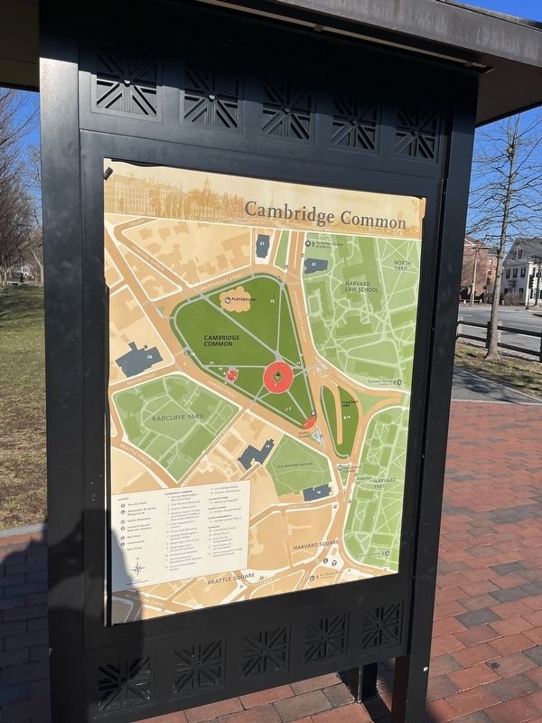
The Common became a civic space after the Civil War. Four cannons left behind by the British in 1776 are reminders of the Siege of Boston, while the Soldiers Monument (1870) honors 4,588 Union servicemen. To celebrate the Centennial in 1876, the city installed granite markers for the Election Oak and the Washington Elm. Dawes Island was created in 1975 as a Bicentennial memorial to William Dawes, who rode through Cambridge on the night of April 18-19, 1775 to warn of the British advance on Lexington and Concord. A descendant of early settler John Bridge erected his statue in 1882. The Prince Hall monument recalls an African American patriot, and a sculpture that evokes the Great Famine of 1845-1852 in Ireland.
The Park
In 1918, the U.S. Navy enclosed the common with a high fence and constructed barracks for sailors attending a radio school at Harvard. After World War I, the city planted more trees, paved the paths, and installed benches, lighting, and a playground. In the 1970s, the Common hosted antiwar demonstrations, civil rights protests, and public concerts. Today it is a quiet space for recreation and leisure.
[Timeline:]
1630
Cambridge is founded as the capital of the Massachusetts Bay Colony. The original boundaries of the town included today's Newton on the south and a part of Billerica on the north.
1724
The Cow Common is reduced to its present-day dimensions.
1775
Minutemen
1830
The Common is enclosed as a park.
1870
The Soldiers Monument is erected.
1909-12
A subway ramp and tunnel are built under Flagstaff Park.
1918
The Naval Radio School barracks are erected and public access to the Common is prohibited.
1923
The Washington Elm falls; police are called to repel souvenir gatherers.
1932
The city trades a corner of the Common to Harvard and receives a site of Broadway for a new fire station.
1968-74
The Common becomes a gathering place for anti-war protests, rallies, and concerts.
1975
Dawes Island is created as a memorial to William Dawes, who rode on the same night as Paul Revere using a separate route through Cambridge to warn of the British advance on Lexington and Concord.
Topics. This historical marker is listed in these topic lists: Colonial Era • Communications • Education • Parks & Recreational Areas • Settlements & Settlers • War, US Revolutionary • War, World I. A significant historical date for this entry is April 18, 1775.
Location. 42° 22.544′ N, 71°
Other nearby markers. At least 8 other markers are within walking distance of this marker. George Washington (a few steps from this marker); Old Cambridge (within shouting distance of this marker); Old Cambridge / Religion and Government in the Early History of Cambridge (within shouting distance of this marker); Route of William Dawes (within shouting distance of this marker); a different marker also named Old Cambridge (within shouting distance of this marker); History of Cambridge (within shouting distance of this marker); An Gorta Mór - The Great Hunger (within shouting distance of this marker); Revolutionary War Memorial (within shouting distance of this marker). Touch for a list and map of all markers in Cambridge.
Credits. This page was last revised on February 1, 2023. It was originally submitted on February 1, 2023, by Devry Becker Jones of Washington, District of Columbia. This page has been viewed 188 times since then and 59 times this year. Photos: 1, 2, 3, 4. submitted on February 1, 2023, by Devry Becker Jones of Washington, District of Columbia.


