Gainesville in Prince William County, Virginia — The American South (Mid-Atlantic)
The Shirley Cemetery
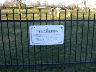
Photographed by Kevin White, February 4, 2007
1. The Shirely Cemetery Marker
Richard Shirley was a farmer and tavern keeper who owned approximately 400 acres of land near Gainesville on the Warrenton Turnpike, modern day Route 29.
Topics. This historical marker is listed in these topic lists: Agriculture • Cemeteries & Burial Sites • Industry & Commerce • Roads & Vehicles.
Location. 38° 47.627′ N, 77° 36.554′ W. Marker is in Gainesville, Virginia, in Prince William County. It is on Linton Hall Road (County Route 619). Touch for map. Marker is in this post office area: Gainesville VA 20155, United States of America. Touch for directions.

Regionally, this marker is in the Washington Metropolitan Area, in Northern Virginia, and in the Piedmont. It is also in the American South, specifically in the Upper South, in the Mid-Atlantic, and on the Eastern Seaboard. Globally, it is in the North Atlantic Region, North America, the Western Hemisphere, the Western World, and the
this page online
Other nearby markers. At least 8 other markers are within 2 miles of this marker, measured as the crow flies: The Macrae School (approx. half a mile away); Home of Thomas B. Gaines (approx. 0.6 miles away); Rock Fight (approx. 1.4 miles away); Bull Run Battlefields (approx. 1.4 miles away); Campaign of Second Manassas (approx. 1.4 miles away); Second Battle of Manassas (approx. 1.4 miles away); Lee, Longstreet and Jackson Meeting (approx. 1.8 miles away); William Edward Ray, Sr. (approx. 1.9 miles away). Touch for a list and map of all markers in Gainesville.
More about this marker. Cemetery and marker are in the Virginia Gateway shopping center.
Credits. This page was last revised on December 26, 2019. It was originally submitted on August 25, 2007, by Kevin W. of Stafford, Virginia. This page has been viewed 4,287 times since then and 142 times this year. Photo 1. submitted on August 25, 2007, by Kevin W. of Stafford, Virginia. • J. J. Prats was the editor who published this page.
