
Edgewater in Anne Arundel County, Maryland — The American Northeast (Mid-Atlantic)
The Ferry at London Town
Photographed by F. Robby, November 7, 2007
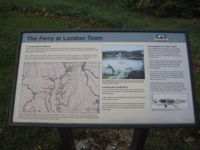
1. The Ferry at London Town Marker
A Transportation Network
Ferries were a critical link in the colonial road system. The ferry crossing at London Town was part of a larger transportation network that extended from Virginia to New York, moving people and goods to market along with the news of the day.
By the 1730s, nearly every road in Anne Arundel County led to a ferry crossing or a boat landing. Travelers often had to wait for the ferry, giving rise to a number of taverns or "ordinaries" at the landings. Due to its location, London Town became a busy port town, which at its height had perhaps 300 residents.
Crossing the South River
The London Town ferry was a small vessel, about 30 feet long and rowed by slaves or indentured servants owned by the ferrykeeper.
A ferry crossing was established at London Town sometime in the 1680s, or before.
Ferryboats crossed the river several times a day. The landing across from London Town was called Ferry Point and the road from there led to Annapolis, only three and half miles away.
Ferrymasters at London Town
David Macklefish, an immigrant from Scotland, was London Town's first ferrykeeper. Running
this page online
Each year the license had to be renewed. A ferrymaster could lose his or her license if they did not run a safe and efficient service. The days and times of ferry service, as well as prices were regulated.
From 1715 to 1740, traffic was so brisk in London Town that it supported two ferryboat crossings. William Wooton took over the Macklefish ferry, or the "old"ferry, in 1727. This was abandoned after Wooton's death in 1740.
Edward Rumney, the tavernkeeper, started the second or "new" ferry in 1715, located at the end of Scott Street. Later operated by Stephen West and William Brown, the ferry continued to operate well into the 1800s, after the town's demise.
[Captions:]
Colonial Transportation System: This detail from The State of Maryland, by Samuel Lewis, 1795, shows the road network that existed in the Chesapeake Bay region during most of the colonial period. London Town was located at an important junction of roads. Anyone traveling from Williamsburg, Virginia, to Philadelphia, Pennsylvania or New York, New York most likely came through London Town and crossed the South River by ferry. Ferry crossings are shown in blue and roads are shown in yellow.
Ferry Landing: Painting of the London Town Ferry, looking across the South River to the London Town peninsula, by Mary Duvall circa 1840. Courtesy of Elizabeth and Peter Edmondo.
Ferry: A colonial ferry boat. Illustration by Edwin Tunis.
Erected by Chesapeake
Photographed by F. Robby, July 23, 2009
2. The Ferry at London Town
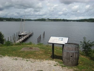
The pier shown is the approximate location of the "old" ferry. The "new" ferry would have been to the right of the picture.
Topics. This historical marker is listed in these topic lists: Colonial Era • Industry & Commerce • Roads & Vehicles • Settlements & Settlers • Waterways & Vessels. A significant historical year for this entry is 1795.
Location. This marker has been replaced by another marker nearby. It was located near 38° 56.492′ N, 76° 32.376′ W. Marker was in Edgewater, Maryland, in Anne Arundel County. It could be reached from Londontown Road 1.3 miles north of Mayo Road (Route 253), on the right when traveling west. Marker is on the grounds of London Town Park, at the end of Londowntown Road, near the brick house. Touch for map. Marker was in this post office area: Edgewater MD 21037, United States of America. Touch for directions.

Regionally, this marker was in Central Maryland. It was also in the American Mid-Atlantic, in the Chesapeake Bay Region, and on the Eastern Seaboard. Globally, it was in the North Atlantic Region, North America, the Western Hemisphere, the Western World, and the Anglosphere. Historically, it found itself in what was once one of the original Thirteen Colonies and also the Antebellum South.
Other nearby markers. At least 8 other markers are within walking distance of this location: The South River (here, next to this marker); Slavery at London Town (here, next to this marker); The Almshouse (within shouting distance of this marker); London Town Ferry (within shouting distance of this marker); a different marker also named William Brown House (within shouting distance of this marker); Scott Street (within shouting distance of this marker); The Carpenter's Shop (within shouting distance of this marker); Tobacco Barn (about 300 feet away). Touch for a list and map of all markers in Edgewater.
Other markers no longer nearby. William Brown House (was within shouting distance of this marker but has been replaced with another marker now near it); Dr. Hill's Medicinal Plants (was within shouting distance of this marker but has been replaced with another marker now near it); Archaeology at London Town (was within shouting distance of this marker but has been replaced with another marker now near it); Establishing a Colonial Town (was within shouting distance of this marker but has been replaced with another marker now near it); The Lord Mayor's Tenement (was within shouting distance of this marker but has been replaced with another marker now near it); Historic London Town and Gardens (was about 300 feet away, measured in a direct line but has been replaced with another marker now near it).
Credits. This page was last revised on August 1, 2026. It was originally submitted on September 3, 2009, by F. Robby of Baltimore, Maryland. This page has been viewed 2,008 times since then and 76 times this year. Photos: 1, 2. submitted on September 3, 2009, by F. Robby of Baltimore, Maryland.
