
South Elmwood in Providence in Providence County, Rhode Island — The American Northeast (New England)
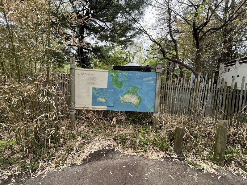
Land Bridges
Australasia 18,000 years ago

At least seven ice ages have chilled the earth over the last 1.6 million years. With each cooling, popular ice caps grow, ocean levels fall, and new habitats are created. When the planet warms, the oceans rise again, relocating and isolating plants and animals. Isolated populations must then adapt to their new homes or they will slowly diseappear.
During the ice age 18,000 years ago Australasia looked like the large map on the right. A lower sea level created land bridges between islands. But the deep ocean trench between Bali and Lombok remained flooded with seawater. This water barrier prevented the mixing of larger Asian and Australian mammals.
Like other animals, humans used land bridges to explore and settle new territory. Early arrivals and later immigrants settled in isolated island villages where thousands of unique cultures developed. New Guinea along has more than 1000 local languages!
In more recent times, human overpopulation and overuse of island resources (through clear-cut logging, mining, and conversion to farmland) threaten the fragile environment of these jewels in the sea.
"Should civilizedman ever reach these…lands…he will so disturb…nature as to cause the disappearance, and finally the extinction, of these [animals]…"
Click or scan to see
this page online
Alfred Russel Wallace
Erected by Roger Williams Park Zoo.
Topics. This historical marker is listed in these topic lists: Anthropology & Archaeology • Immigration • Natural Features • Settlements & Settlers.
Location. 41° 47.242′ N, 71° 25.08′ W. Marker is in Providence, Rhode Island, in Providence County. It is in South Elmwood. It can be reached from FC Greene Memorial Boulevard south of Hawthorne Avenue, on the right when traveling south. The marker stands on the grounds of Roger Williams Park Zoo. Touch for map. Marker is at or near this postal address: 1000 Elmwood Ave, Providence RI 02905, United States of America. Touch for directions.

Regionally, this marker is on Rhode Island’s Narragansett Bay. It is also in the American Northeast and in New England. Globally, it is in the North Atlantic Region, North America, the Western Hemisphere, the Western World, and the Anglosphere. Historically, it finds itself in
Other nearby markers. At least 8 other markers are within walking distance of this marker: Bald Eagle (within shouting distance of this marker); Golden Eagle (within shouting distance of this marker); a different marker also named Golden Eagle (within shouting distance of this marker); a different marker also named Bald Eagle (within shouting distance of this marker); a different marker also named Bald Eagle (within shouting distance of this marker); a different marker also named Golden Eagle (within shouting distance of this marker); A Conservation Success Story (within shouting distance of this marker); Wild Turkey (within shouting distance of this marker). Touch for a list and map of all markers in Providence.
Additional commentary.
1. About language of the marker
The quote on the marker, indicating a bias with the use of the word civilized, has been transcribed verbatim. The views indicated on the marker are not to be interpreted as necessarily the views of the contributor.
— Submitted May 7, 2023, by Devry Becker Jones of Washington, District of Columbia.
Additional keywords. prehistory
Credits. This page was last revised on May 7, 2023. It was originally submitted on May 7, 2023, by Devry Becker Jones of Washington, District of Columbia. This page has been viewed 130 times since then and 12 times this year. Photos: 1, 2. submitted on May 7, 2023, by Devry Becker Jones of Washington, District of Columbia.
