Downtown Providence in Providence County, Rhode Island — The American Northeast (New England)
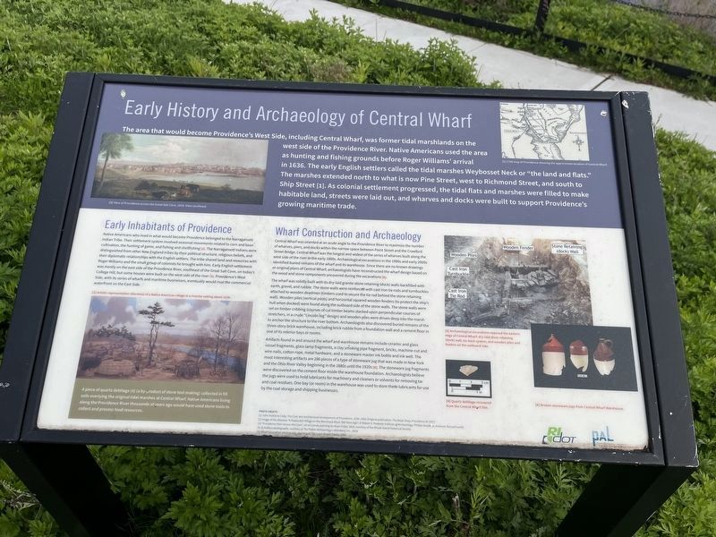
Early History and Archaeology of Central Wharf

Photographed By Devry Becker Jones (CC0), May 4, 2023
1. Early History and Archaeology of Central Wharf Marker
The area that would become Providence's West Side, including Central Wharf, was former tidal marshlands on the west side of the Providence River. Native Americans used the area as hunting and fishing grounds before Roger Williams' arrival in 1636. The early English settlers called the tidal marshes Weybosset Neck or "the land and flats." The marshes extended north to what is now Pine Street, west to Richmond Street, and south to Ship Street [1]. As colonial settlement progressed, the tidal flats and marshes were filled to make habitable land, streets were laid out, and wharves and docks were built to support Providence's growing maritime trade.
Early Inhabitants of Providence
Native Americans who lived in what would become Providence belonged to the Narragansett Indian Tribe. Their settlement system involved seasonal movmeents related to corn and bean cultivation, the hunting of game, and fishing and shellfishing [2]. The Narragansett Indians were distinguished from other New England tribes by their political structure, religious beliefs and their diplomatic relationships with the English settlers. The tribe shared land and resources with Roger Williams and the small group of colonists he brought with him. Early English settlement was mostly on the east side of the Providence River, southeast of the Great Salt Cove, on today's College Hill, but some houses were built on the west side of the river [3]. Providence's West Side, with its series of wharfs and maritime businesses, eventually rival the commercial waterfront on the East Side.
Wharf Construction and Archaeology
Central Wharf was oriented at an acute angle to the Providence River to maximize the number of wharves, piers, and docks within the narrow space between Point Street and the Crawford Street Bridge. Central Wharf was the longest and widest of the series of wharves built along the west side of the river in the early 1800s. Archaeological excavations in the 1990s and early 2000s identified buried remains of the wharf and its warehouse. Since there are no known drawings or original plans of Central Wharf, archaeologists have reconstructed the wharf design based on the wood and stone components uncovered during the excavations [5].
The wharf was solidly built with its dry-laid granite stone retaining (dock) walls backfilled with earth, gravel, and rubble. The stone walls were reinforced with cast iron tie rods and turnbuckles attached to wooden deadmen (timbers used to secure the tie rod behind the stone retaining wall). Wooden piles (vertical posts) and horizontal squared wooden

Photographed By Devry Becker Jones (CC0), May 4, 2023
2. Early History and Archaeology of Central Wharf Marker
Artifacts found in and around the wharf and warehouse remains include ceramic and glass vessel fragments, glass lamp fragments, a clay smoking pipe fragment, bricks, machine-cut and wire nails, cotton rope, metal hardware, and a stoneware master ink bottle and ink well. The most interesting artifacts are 286 pieces of a type of stoneware jug that was made in New York and the Ohio River Valley beginning in the 1880s until the 1920s [6]. The stoneware jug fragments were discovered on the cement floor inside the warehouse foundation. Archaeologists believe the jugs were used to hold lubricants for machinery and cleaners or solvents for removing tar and coal residues. One bay (or room) in the warehouse was used to store these lubricants for use by the coal storage and shipping businesses.
[Captions:]
[1] 1700 map of Providence showing the approximate location of Central Wharf.
[3] View of Providence across the Great Salt Cove, 1819. View southeast.
A piece of quartz debitage [4] (a by-product of stone tool making) collected in fill soils overlaying the original tidal marshes at Central Wharf. Native Americans living along the Providence River thousands of years ago would have used stone tools to collect and process food resources.
[4] Quartz debitage recovered from the Central Wharf Site.
[5] Archaeological excavations exposed the eastern edge of Central Wharf: dry-laid stone retaining (dock) wall, tie-back system, and wooden piles and fenders on the outboard side.
[6] Broken stoneware jugs from Central Wharf Warehouse.
Erected by Rhode Island Deportment of Transportation (RIDOT); Public Archaeology Laboratory.
Topics. This historical marker is listed in these topic lists: Anthropology & Archaeology • Colonial Era • Industry & Commerce • Native Americans • Settlements & Settlers • Waterways & Vessels. A significant historical year for this entry is 1636.
Location. 41° 49.202′ N, 71° 24.376′ W. Marker is in Providence, Rhode Island, in Providence County. It is in Downtown Providence. Marker is at the intersection of Eddy Street and Ship Street, on the right when traveling north on Eddy Street. Touch for map. Marker is at or near this postal address: 120 Peck St, Providence RI 02903, United States of America. Touch for directions.
Other nearby markers. At least 8 other markers are within walking distance of this marker. Central Wharf Shipping, Whaling, and Other Industries (here, next to this marker); Providence (about 700 feet away, measured in a direct line); Rise of the Gangways (1704-1844) / Fall of the Gangways (1844-1983) (about 700 feet away); The Changing Face of the West Bank / The West Bank (approx. 0.2 miles away); Fox Point Veterans Memorial (approx. 0.2 miles away); Revolutions: American and Industrial (approx. 0.2 miles away); Crawford Street Bridge Without Crawford Street (approx. 0.2 miles away); HMS Gaspee (approx. ¼ mile away). Touch for a list and map of all markers in Providence.
Credits. This page was last revised on May 29, 2023. It was originally submitted on May 8, 2023, by Devry Becker Jones of Washington, District of Columbia. This page has been viewed 51 times since then and 13 times this year. Photos: 1, 2. submitted on May 8, 2023, by Devry Becker Jones of Washington, District of Columbia.