Emporia, Virginia — The American South (Mid-Atlantic)
Meherrin River Trail
Emporia, Virginia. Chowan River Basin
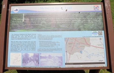
"The railroad bridge was a prime target during the Civil War. The Confederates built three forts on the south side of the bridge and rifle pits and obstructions on the north side. On December 7-12, 1864 the Yankees made their “Hicksford Raid”, [early Emporia], moving south across the Nottaway at Freeman’s Bridge. They succeeded in burning the railway bridge at Fort Nottaway, but were successfully repulsed by the Confederates guarding the bridge here at Hicksford.”
-Dr. William E. Trout, III and Jeff Turner, The Blackwater, Nottaway and Meherrin River Atlas
“The Petersburg (Petersburg and Weldon) Railroad reached Emporia in 1833, crossing the river on a bridge with 200 stone piers…BELFIELD and HICKSFORD were still separate towns, and would not merge to form EMPORIA for half a century.
After the railway came to Emporia, there was great excitement in the 1830’s and 40’s about making the upper river navigable by batteaux, so farmers living in isolated parts of Virginia could boat their products down to the railway depot. For a while, it was seen as a sure thing. But as far as we know no navigation improvements were ever made on the Meherrin above Emporia.” -Dr. William E. Trout, III and Jeff Turner, The Blackwater, Nottaway and Meherrin River Atlas
(sidebar)
Paddle Tips
• Explore the Meherrin River as it meanders through Brunswick & Greensville Counties on its way to the Chowan River and Albemarle Sound. The 37 mile Brunswick County section is designated a Scenic by the VA Department of Conservation and Recreation.
• Check USGS water gages accessible online.
• Always wear a Personal Floatation Device.
• River Sections (approximate distances):
- US1 to Rustic Rd. (Gee’s Bridge off Old Indian Rd.) – 2 miles
- Rustic Rd. to Robinson’s Ferry Rd./Rte. 644 (Midway) – 8.5 miles
- Robinson’s Ferry Rd./Rte. 644 to Rte. 46 – 6.5 miles
- Rte. 46 to Iron Bridge Rd./Rte. 715 (Gholson’s Bridge) – 1.5 miles
- Iron Bridge Rd./Rte. 715 (Gholson’s Bridge to Rte. 670 – 5.5 miles
- Rte. 670 to Emporia Lake access – 14.7 miles
- Emporia Farmer’s Market access to Meherrin Park - .7 miles
• Paddling the Meherrin below Emporia will be greatly enhanced when access for a take out near Ferguson’s Island/Southampton County Line can be obtained. At the present one is limited to returning to Meherrin Park or the Farmer’s Markey Access from point downstream.
Erected by Upper Reach Roanoke River Basin Association.
Topics. This historical marker is listed in these topic lists: Environment • Forts and Castles • Parks & Recreational Areas • Railroads & Streetcars • War, US Civil • Waterways & Vessels. A significant historical date for this entry is December 7, 1864.
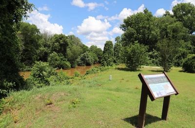
Location. 36° 41.365′ N, 77° 32.464′ W. Marker is in Emporia, Virginia. Marker is on South Main Street (U.S. 301) 0.1 miles north of Battery Avenue, on the right when traveling north. Touch for map. Marker is at or near this postal address: 107 S Main St, Emporia VA 23847, United States of America. Touch for directions.
Other nearby markers. At least 8 other markers are within walking distance of this marker. Tarleton's Movements (within shouting distance of this marker); Shiloh Baptist Church (about 400 feet away, measured in a direct line); Hicksford Raid Monument (about 500 feet away); Hicksford Raid (about 500 feet away); Emporia – Greensville Veteran War Memorial (about 500 feet away); Benjamin D. Tillar, Jr. (about 700 feet away); Robert Hicks (approx. 0.2 miles away); Chaplain Thomas M. Bulla (approx. 0.2 miles away). Touch for a list and map of all markers in Emporia.
More about this marker. "Nottoway" is misspelled as "Nottaway".
Credits. This page was last revised on June 27, 2023. It was originally submitted on June 27, 2023, by Dave W of Co, Colorado. This page has been viewed 136 times since then and 59 times this year. Photos: 1, 2. submitted on June 27, 2023, by Dave W of Co, Colorado. • Bernard Fisher was the editor who published this page.

