Manteo in Dare County, North Carolina — The American South (South Atlantic)
Exploring the Unknown
| — | Fort Raleigh National Historic Site | — |
Photographed by Sean C Bath, July 18, 2023
1. Exploring the Unknown Marker
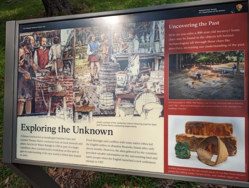
Food shortages and conflicts with some native tribes led the English settlers to abandon Roanoke Island after only eleven months. However, the data gathered by the scientists provided valuable information on the surrounding land and native people when the English launched a new settlement attempt in 1587.
(center caption) Artist's conception of the workshop interior showing Joachim Gans and Thomas Hariot conducting experiments.
Uncovering the Past
How do you solve a 400-year-old mystery? Some clues may be found in the objects left behind. Archeologists sift through these clues like detectives, increasing our understanding of the past.
(center right caption) First excavated in 1959, the historic use of this structure was a mystery until 1991, when archeologists discovered artifacts that revealed the building's
this page online
(lower right caption) Artifacts discovered on this site include pieces of crucibles (heat-resistant pottery for melting metal), furnace bricks, and smelted copper ore.
Erected by National Park Service, U.S. Department of the Interior.
Topics. This historical marker is listed in these topic lists: Anthropology & Archaeology • Colonial Era • Science & Medicine • Settlements & Settlers. A significant historical year for this entry is 1585.
Location. 35° 56.286′ N, 75° 42.542′ W. Marker is in Manteo, North Carolina, in Dare County. It can be reached from Fort Raleigh Road north of National Park Road when traveling north. Touch for map. Marker is at or near this postal address: 1500 Fort Raleigh Rd, Manteo NC 27954, United States of America. Touch for directions.

Regionally, this marker is in North Carolina’s Coastal Plain and on the Outer Banks. It is also in the American South, specifically in the Upper South, in the Tidewater, and on the Eastern Seaboard. Globally, it is in the North Atlantic Region, North America, the Western Hemisphere, the Western World, and the Anglosphere. Historically, it finds itself in what was once the territory of the Mississippian Culture, one of the original Thirteen Colonies, one of the Confederate States of America, and the Antebellum South.
Other nearby markers. At least 8 other markers are within walking distance of this marker: English Explorers' Earthwork (a few steps from this marker); Reconstructed Past (within shouting distance of this marker); Thomas Hariot Trail (within shouting distance of this marker); Science in the New World (within shouting distance of this marker); History Comes Alive (within shouting distance of this marker); Join the Exploration Party (within shouting distance of this marker); The New Fort in Virginia / Virginia Dare (within shouting distance of this marker); Cora Mae Basnight (within shouting distance of this marker). Touch for a list and map of all markers in Manteo.
Also see . . . Fort Raleigh National Historic Site. National Park Service. (Submitted on December 18, 2023.)
Credits. This page was last revised on December 18, 2023. It was originally submitted on December 16, 2023, by Sean C Bath of Silver Spring, Maryland. This page has been viewed 566 times since then and 64 times this year. Photo 1. submitted on December 16, 2023, by Sean C Bath of Silver Spring, Maryland. • Bernard Fisher was the editor who published this page.
