Marker Logo
THE HISTORICAL
MARKER DATABASE
“Bite-Size Bits of Local, National, and Global History”
Jackson Township near Harrod in Allen County, Ohio — The American Midwest (Great Lakes)
 

McKee's Hill
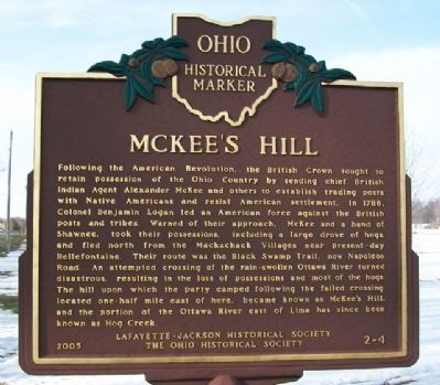
 
 
McKee's Hill Marker image. Click for full size.
Photographed by William Fischer, Jr., March 7, 2010
1. McKee's Hill Marker
Inscription. Following the American Revolution, the British Crown sought to retain possession of the Ohio Country by sending chief British Indian Agent Alexander McKee and others to establish trading posts with Native Americans and resist American settlement. In 1786, Colonel Benjamin Logan led an American force against the British posts and tribes. Warned of their approach, McKee and a band of Shawnee, took their possessions, including a large drove of hogs, and fled north from the Mackachack Villages near present-day Bellefontaine. Their route was the Black Swamp Trail, now Napoleon Road. An attempted crossing of the rain-swollen Ottawa River turned disastrous, resulting in the loss of possessions and most of the hogs. The hill upon which the party camped following the failed crossing, located one-half mile east of here, became known as McKee's Hill, and the portion of the Ottawa River east of Lima has since been known as Hog Creek.
 
Erected 2005 by Lafayette-Jackson Historical Society and The Ohio Historical Society. (Marker Number 2-4.)
 
Topics and series. This historical marker is listed in these topic lists: Indigenous Peoples and Communities
Paid Advertisement
Click or scan to see
this page online
Settlements & SettlersWars, US IndianWaterways & Vessels. In addition, it is included in the Ohio Historical Society / The Ohio History Connection series list. A significant historical year for this entry is 1786.
 
Location. 40° 46.155′ N, 83° 57.85′ W. Marker is near Harrod, Ohio, in Allen County. It is in Jackson Township. It is on Lafayette Road 0.1 miles north of Ada Road (Ohio Route 81), on the right when traveling north. Touch for map. Marker is at or near this postal address: 2115 Lafayette Road, Harrod OH 45850, United States of America. Touch for directions.

Regionally, this marker is in Ohio’s Till Plains. It is also in the American Midwest and in the Corn Belt. Globally, it is in North America, the Western Hemisphere, the Western World, and the Anglosphere. Historically, it finds itself in what was once the Haudenosaunee (Iroquois) Confederacy, the territory of the Mississippian Culture, and the Northwest Territory.

Other nearby markers. At least 8 other markers are within 5 miles of this marker, measured as the crow flies: Veterans Monument / Memorial Garden (approx. one mile away); LaFayette - Jackson Township Civil War Memorial
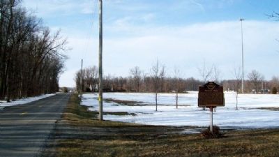
McKee's Hill Marker image. Click for full size.
Photographed by William Fischer, Jr., March 7, 2010
2. McKee's Hill Marker
Looking north along Lafayette Road.
(approx. one mile away); P-39 Airacobra Crash Site (approx. 1.7 miles away); The Hog Creek Settlement (approx. 2.6 miles away); Rhode State College - Tech Ed Lab (approx. 3.8 miles away); The Ohio State University at Lima - Galvin Hall (approx. 3.9 miles away); Beaverdam Village Park (approx. 4.3 miles away); Harrod (approx. 4.4 miles away).
 
 
Credits. This page was last revised on January 11, 2025. It was originally submitted on March 16, 2010, by William Fischer, Jr. of Reynoldsburg, Ohio. This page has been viewed 5,060 times since then and 160 times this year. Last updated on December 29, 2023, by Grant & Mary Ann Fish of Galloway, Ohio. Photos:   1, 2. submitted on March 16, 2010, by William Fischer, Jr. of Reynoldsburg, Ohio. • Devry Becker Jones was the editor who published this page.

m=238374

CeraNet Cloud Computing sponsors the Historical Marker Database.
This website earns income from purchases you make after using our links to Amazon.com. We appreciate your support.
Paid Advertisement
Jul. 20, 2026