Napoleon Township in Jackson County, Michigan — The American Midwest (Great Lakes)
Nottawa Sepee Trail
Indian travel route passed through Napoleon when American settlers arrived
Photographed by J.T. Lambrou, June 4, 2024
1. Nottawa Sepee Trail Marker
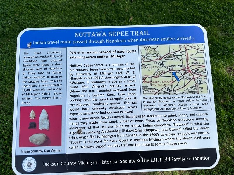
Part of an ancient network of travel routes extending across southern Michigan
Nottawa Sepee Street is a remnant of the old Nottawa Sepee Indian trail documented by University of Michigan Prof. W. B. Hinsdale in his 1931 Archaeological Atlas of Michigan. It continued in use as a travel route after American settlers arrived. Where the trail extended westward from Napoleon it became Stony Lake Road. Looking east, the street abruptly ends at the Napoleon sandstone quarry. The trail would have originally continued across exposed sandstone bedrock and followed what is now Austin Road eastward. Indians used sandstone to grind, shape, and smooth things they made from wood, antler or bone. Pieces of Napoleon sandstone showing indications of that use are found on nearby Indian campsites. "Nottawa" is what the Algonquan speaking Anishinabeg (Potawatomi, Chippewa, and Ottawa) called the Huron tribe, which fled to Michigan from Canada in the 1600's to escape Iroquois war parties. "Sepee" is the word for river. Rivers in southern Michigan where the Huron lived were called "Nottawa Sepee" and this trail was the route to some of
this page online
[Caption:]
The stone arrowhead, spearpoint, musket flint, and sandstone tool pictured below were found a short distance west of Napoleon at Stony Lake on former Indian campsites adjacent to the Nottawa Sepee trail. The spearpoint is approximately 12,000 years old and is one of Michigan's oldest artifacts. The musket flint is British.
The blue arrow points to the Nottawa Sepee Trail, in use for thousands of years before European explorers or American settlers arrived. Map excerpt from Archaeological Atlas of Michigan.
Erected 2024 by Jackson County Michigan Historical Society & The L.H. Field Family Foundation.
Topics. This historical marker is listed in these topic lists: Anthropology & Archaeology • Indigenous Peoples and Communities • Roads & Vehicles. A significant historical year for this entry is 1931.
Location. 42° 9.619′ N, 84° 14.718′ W. Marker is near Napoleon, Michigan, in Jackson County. It is in Napoleon Township. It is on Nottawasepee just west of Chicago Road, on the right when traveling west. Touch for map. Marker is at or near this postal address: 303 Nottawasepee, Napoleon MI 49261,
Photographed by J.T. Lambrou, June 4, 2024
2. Nottawa Sepee Trail Marker

Regionally, this marker is in Mid-Michigan. It is also in the American Midwest. Globally, it is in North America, the Western Hemisphere, the Western World, and the Anglosphere. Historically, it finds itself in what was once the Northwest Territory.
Other nearby markers. At least 8 other markers are within 4 miles of this marker, measured as the crow flies: Napoleon Township World War II Veterans Memorial (within shouting distance of this marker); Veterans Memorial (approx. 0.4 miles away); Corporal Glenn Kleile (approx. 0.4 miles away); Norvell Community Baptist Church (approx. 3.2 miles away); Henry Ford in Brooklyn (approx. 3.3 miles away); Ford Motor Company Brooklyn Plant: (approx. 3½ miles away); a different marker also named Veterans Memorial (approx. 3.6 miles away); Brooklyn Presbyterian Church (approx. 3.6 miles away). Touch for a list and map of all markers in Napoleon.
Credits. This page was last revised on June 9, 2024. It was originally submitted on June 4, 2024, by J.T. Lambrou of New Boston, Michigan. This page has been viewed 368 times since then and 63 times this year. Photos: 1, 2. submitted on June 4, 2024, by J.T. Lambrou of New Boston, Michigan. • Devry Becker Jones was the editor who published this page.
