Near Port Rowan in Norfolk County, Ontario — Central Canada (North America)
Long Point Portage
⎯⎯⎯
Le Portage de Long Point

Photographed by Tim Boyd, July 8, 2024
1. Long Point Portage Marker

Long Point Portage
This portage, which crossed the isthmus joining Long Point to the mainland, was used by travellers in small craft following the north shore of Lake Erie in order to avoid the open waters and the length of the journey around the Point. Although used earlier by the Indians, the portage was first recorded in 1670 by two Sulpician missionaries, Dollier de Casson and René de Bréhant de Galinée. For about 150 years traffic increased over the carrying place, first as a result of the French expansion to the south-west, including the founding of Detroit in 1701, and, after 1783, because of the movement of settlers into this region. The portage was abandoned in 1833 when a storm broke a navigable channel through the isthmus.
Erected by the Archaeological and Historic Sites Board, Ministry of Colleges and Universities
Ce portage traversait l'isthme qui unit Long Point à la terre ferme. Les voyageurs, côtoyant en légère embarcation la rive nord du lac Erié, s'en servaient pour éviter les eaux du large et le long détour de la Pointe. Utilisé autrefois par les Indiens, ce
this page online
Plaque érigée par le Conseil des lieur archéologiques et historiques de l'Ontario, Ministère des Collèges et Universités
Erected by Ontario Archaeological and Historic Sites Board.
Topics and series. This historical marker is listed in these topic lists: Colonial Era • Exploration • Indigenous Peoples and Communities • Waterways & Vessels. In addition, it is included in the Canada, Ontario Heritage Trust series list. A significant historical year for this entry is 1670.
Location. 42° 34.86′ N, 80° 23.742′ W. Marker is near Port Rowan, Ontario, in Norfolk County. It is on Erie Boulevard east of Long Point Road, on the right when traveling east.

Photographed by Tim Boyd, July 8, 2024
2. Long Point Portage / Le Portage de Long Point Marker

Regionally, this marker is in the Southwest Ontario Area and in Southwestern Ontario. It is also in Central Canada. Globally, it is in North America, on the Great Lakes, in the Western Hemisphere, in the Western World, and in the Anglosphere. Historically, it finds itself in what was once a British colony, the Viceroyalty of New France, the Haudenosaunee (Iroquois) Confederacy, and Rupert’s Land.
Other nearby markers. At least 8 other markers are within 6 kilometers of this marker, measured as the crow flies: Bird Studies Canada (approx. 6.4 kilometers away); Long Point Biosphere (approx. 6.4 kilometers away); Long Point (approx. 6.4 kilometers away); Long Point Bay (approx. 6.4 kilometers away); The Heroine of Long Point (approx. 6.4 kilometers away); Port Rowan Cenotaph (approx. 6.4 kilometers away); Port Rowan History (approx. 6.4 kilometers away); Our Oldest Heritage (approx. 6.4 kilometers away). Touch for a list and map of all markers in Port

Photographed by Tim Boyd, July 8, 2024
3. Long Point Portage / Le Portage de Long Point Marker
Also see . . . Long Pont, Ontario. Wikipedia entry (Submitted on January 12, 2025, by Larry Gertner of New York, New York.)

Photographed by Tim Boyd, July 8, 2024
4. Long Point Portage / Le Portage de Long Point Marker
Marker on the far right, at the entrance to long Point provincial Park
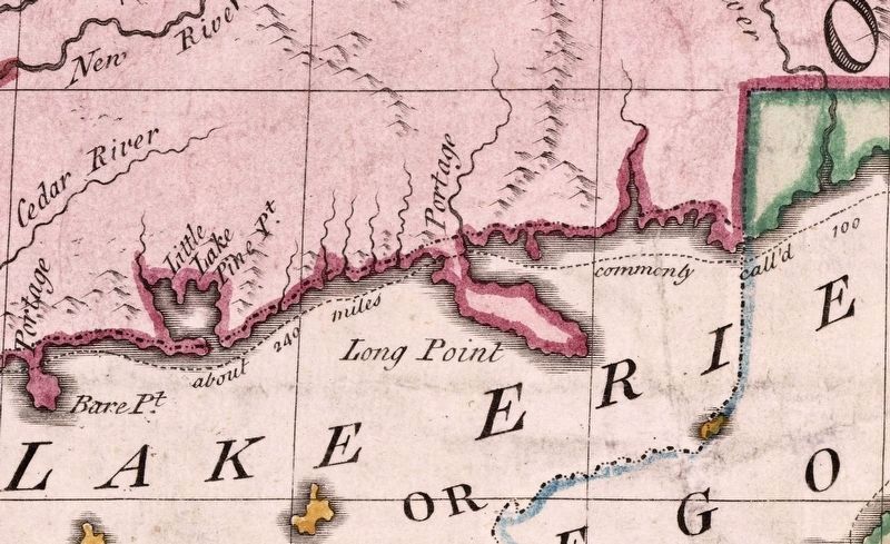
1755
5. Long Point portage, shown on a map of 1755
Mitchell’s map of British and French Dominions in N. America
Credits. This page was last revised on January 12, 2025. It was originally submitted on July 13, 2024, by Tim Boyd of Hamilton, Ontario. This page has been viewed 344 times since then and 41 times this year. Photos: 1, 2, 3, 4, 5. submitted on July 13, 2024, by Tim Boyd of Hamilton, Ontario. • Andrew Ruppenstein was the editor who published this page.
